Download
1 / 2
20 likes | 152 Vues
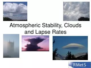
Learn about cumulus clouds formed from lifted air parcels in unstable conditions, seen in weather observations like the Oakland sounding and radar images showing areas of precipitation with large CAPE. Explore this phenomenon to understand thunderstorm development and the vertical profiles of temperature and dew-point temperature in different locations.

E N D
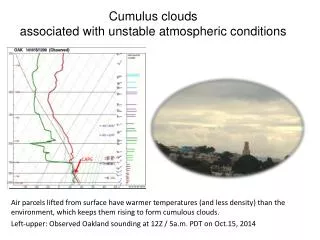
Cumulus clouds associated with unstable atmospheric conditions Air parcels lifted from surface have warmer temperatures (and less density) than the environment, which keeps them rising to form cumulous clouds. Left-upper: Observed Oakland sounding at 12Z / 5a.m. PDT on Oct.15, 2014 CAPE
Thunderstorms in the Eastern U.S. • Upper-left: Observed sounding shows the vertical profile of temperatures and dew-point temperatures in KMHX(Morehead City NC) at 12Z / 5a.m. PDT, on Oct. 15th ,2014, along with large CAPE indicating an absolutely unstable environment, which is associated with thunderstorm development. • Upper-right: Radar image provided by National Weather Service shows the areas of precipitation at 1648Z / 0948a.m. PDT. The colors imply the intensities of precipitation – orange-yellow colors are associated with the heavier rainfall. Large CAPE