Download
1 / 29
290 likes | 413 Vues
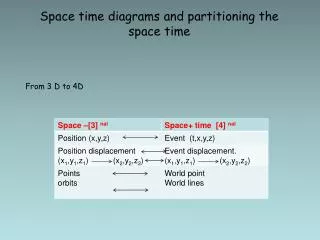
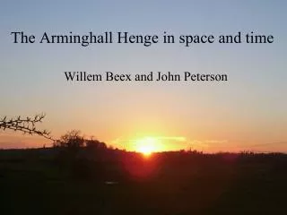
The Arminghall Henge in space and time. Willem Beex and John Peterson. Location. The first view of the Henge. Photographed by Wing Commander Insall, V.C on 18th June 1928. Published: Antiquity 3.2 (1929). N. Neolithic and Bronze Age environment. Landscape and midwinter sunset.

E N D
The Arminghall Henge in space and time Willem Beex and John Peterson
The first view of the Henge Photographed by Wing Commander Insall, V.C on 18th June 1928 Published: Antiquity 3.2 (1929) N
18 Dec 2002 15:35 Chapel Hill
Calculation of sun’s path at mid winter sunset The apparent altitude of the sun’s centre, h, and its azimuth are approximately related (for h < 4 deg.) by a straight line: Where Q is the azimuth of the sun’s centre, is the observer’s latitude, is the obliquity of the ecliptic and r is the increase in apparent altitude due to refraction.
Sources of information and verification The formula for ‘h’ is derived from a paper by G. R. and P. F. Freeman (on Stonehenge) presented to the 33rd annual meeting of the Canadian Archaeological Association and published in 2001. Results of calculations were checked against those published in John North’s “Stonehenge” (1996). By trial and error it was established that a value for the refraction of 0.0081 radians gave the best fit of spreadsheet values to those published by North.
MWSS Simulation (spreadsheet) 5000 years BP
Crough Patrick Rolling Sun Source: http://www.carrowkeel.com/sites/croaghpatrick/reek2.html
Excavation Plan (1936) Location Orientation
Conclusions • Position of the Henge is northeast of the most prominent hill in the area • A midwinter sunset roll down would have been visible in 4,000 BP • This is the first accurate determination of the Henge orientation • Orientation is not accurately towards MWSS • VR allows us to explore alternative hypotheses