Download
1 / 18
180 likes | 319 Vues
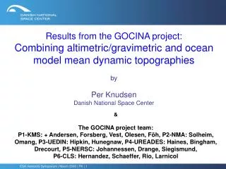
Results from the GOCINA project: Combining altimetric/gravimetric and ocean model mean dynamic topographies by Per Knudsen Danish National Space Center.

E N D
Results from the GOCINA project:Combining altimetric/gravimetric and ocean model mean dynamic topographies byPer KnudsenDanish National Space Center &The GOCINA project team: P1-KMS: + Andersen, Forsberg, Vest, Olesen, Föh, P2-NMA: Solheim, Omang, P3-UEDIN: Hipkin, Hunegnaw, P4-UREADES: Haines, Bingham, Drecourt, P5-NERSC: Johannessen, Drange, Siegismund, P6-CLS: Hernandez, Schaeffer, Rio, Larnicol ESA Venice06 Symposium | March 2006 | PK | 1
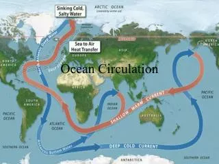
GOCINAGeoid and Ocean Circulation In the North Atlantic • was an EU FP5 project: • For joint exploitation of ENVISAT • and GOCE in ocean circulation • studies: • Climate modeling • Operational assimilation ESA Venice06 Symposium | March 2006 | PK | 2
Results – Individual Components The components: • MSS • MDT • Geoid have been improved. ESA Venice06 Symposium | March 2006 | PK | 3
The MSS and geoid • The MSS has been improved using • T/P, T/P TDM, ERS1 ERM+GM, ERS2 ERM, Geosat GM, and GFO data • The geoid in the Nordic Area and Greenland has been improved using • New airborne data • Adjusted ship data and • GRACE gravity field ESA Venice06 Symposium | March 2006 | PK | 4
The Composite Mean Dynamic Topography ”Ensemble” mean & st. dev. Bingham & Haines The MDTs have been referred to the same time period (1993-2001) and put onto the same 1x1 deg grid. ESA Venice06 Symposium | March 2006 | PK | 5
Composite MDT KMS04 – NAT04 Error fields +-40 cm 10 cm 25 cm ESA Venice06 Symposium | March 2006 | PK | 6
Combining Components The individual techniques are integrated to improve the individual components. This is done using: • Least squares collocation • Optimal combination of gravity data, MSS, and MDT • Iterative combination method • Based on FFT and weighted combinations • Ocean modelling • FOAM • MERCATOR • TOPAZ ESA Venice06 Symposium | March 2006 | PK | 7
Combining Components 1st step: To compute an ocean model free MDT with error estimates for the assimilation using • Least squares collocation and/or • Iterative combination from altimetry and gravimetry only. ESA Venice06 Symposium | March 2006 | PK | 8
Iterative Combination Method MDT ESA Venice06 Symposium | March 2006 | PK | 9
MDT Errors by Collocation – subset of data ESA Venice06 Symposium | March 2006 | PK | 10
Error Covariance Modelling: Rigorous estimation by collocation: Or using the error estimates and the approximation with a fixed correlation length of 0.3º ESA Venice06 Symposium | March 2006 | PK | 11
Combining Components 2nd step: To assimilate altimetry using the Iterative Combination Method MDT with error estimates into • FOAM • MERCATOR, and • TOPAZ operational systems. ESA Venice06 Symposium | March 2006 | PK | 12
ICM OGCMMDTv*v ESA Venice06 Symposium | March 2006 | PK | 13
Next steps: • Analyse impact on • Ocean circulation / transport • Climate prediction • Operational forecasting • Recommendations for integration for GOCE ESA Venice06 Symposium | March 2006 | PK | 14
Obs Obs Simulated Simulated Section Section FOAM FOAM FOAM-C FOAM-C TOPAZ TOPAZ TOPAZ-C TOPAZ-C MERCATOR MERCATOR MERCATOR-C MERCATOR-C Iceland-Greenland Iceland-Greenland N N 0.8 0.8 1 1 0.7 0.7 2.5 2.5 2.2 2.2 4.23 4.23 4.45 4.45 S S 4.3 4.3 7.5 7.5 10.4 10.4 4.8 4.8 5.3 5.3 6.64 6.64 7.68 7.68 Faroe-Iceland Faroe-Iceland N N 3.8 3.8 5 5 5.8 5.8 5.0 5.0 5.2 5.2 - - - - S S 1.0 1.0 1.3 1.3 1.2 1.2 2.3 2.3 2.2 2.2 - - - - Faroe-Shetland Faroe-Shetland N N 3.8 3.8 4.3 4.3 5.9 5.9 3.2 3.2 3.5 3.5 - - - - S S 2.6 2.6 2.4 2.4 1.8 1.8 2.3 2.3 2.2 2.2 - - - - Iceland-Shetland Iceland-Shetland N N 7.6 7.6 9.3 9.3 11.7 11.7 8.2 8.2 8.7 8.7 4.49 4.49 4.36 4.36 S S 3.6 3.6 3.7 3.7 3 3 4.6 4.6 4.4 4.4 3.02 3.02 3.24 3.24 All sections All sections N N 8.4 8.4 10.3 10.3 12.4 12.4 10.7 10.7 10.9 10.9 8.72 8.72 8.81 8.81 S S 7.9 7.9 11.2 11.2 13.4 13.4 9.4 9.4 9.7 9.7 9.66 9.66 10.92 10.92 Net flow through the Green.-Scot. ridge Net flow through the Green.-Scot. ridge 0.5N 0.5N 0.9 S 0.9 S 1 S 1 S 1.3 N 1.3 N 1.2 N 1.2 N 0.94 S 0.94 S 2.09 S 2.09 S Impact on Transport Estimates ESA Venice06 Symposium | March 2006 | PK | 15
Impact on Heat Transport (TW) ESA Venice06 Symposium | March 2006 | PK | 16
Results: Impact on • Ocean circulation / transport • Improved transports – increased agreement with drifter observations • Climate prediction • Decreased model northward net heat transport through the straits • Operational forecasting • More test needed – improvements expected ESA Venice06 Symposium | March 2006 | PK | 17
Results: Recommendations for integration for GOCE • Workshop – prepare and educate the community • Generic algorithms for using GOCE have been developed Further activities for integration for GOCE • GOCE User Toolbox Study (GUTS) • Develop strategies for operational systems ESA Venice06 Symposium | March 2006 | PK | 18