Unveiling Plate Tectonics: Earth's Dynamic Forces
580 likes | 606 Vues
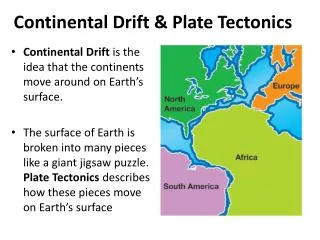
Explore the origins and arrangement of Earth's surface, the concept of plate tectonics, and Alfred Wegener's continental drift hypothesis. Discover how lithospheric plates and tectonic forces shape Earth's geography. Learn how paleoclimate and fossil evidence support the theory of continental drift.

Unveiling Plate Tectonics: Earth's Dynamic Forces
E N D
Presentation Transcript
Tectonics Tectonic Forces are forces generated from within Earth causing rock to become___________. 1. The study of the origin and arrangement of Earth surface including mountain belts, continents, and earthquake belts. deformed Tectonics
Plate Tectonics 1. This is the basic idea that Earths crust is divided into a few large, thick ____________ which are large slabs of the lithosphere. (a) Plates are part of the______________ move slowly and change in size. (b) Plates may be: (a) entirely ___________ rock (b) both ____________ and _____________ rock (c) entirely ______________ rock plates lithosphere sea floor sea floor continental continental
Lithosphere and Upper Mantle Defined by a decrease in P-wave velocities
2. Alfred Wegener and the Continental Drift Hypothesis • German meteorologist • Credited with hypothesis of continental drift
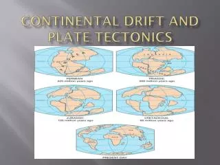
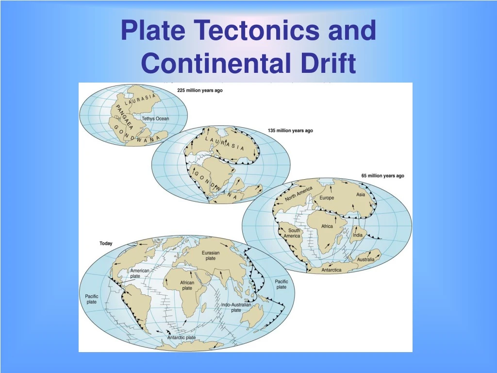
Wegener’s Evidence For Continental Drift Pangaea A. ___________ • Wegener proposed the presence of a giant continent, Pangaea (also spelled Pangea), which literally translated means “all lands.” • When it split apart it separated into two parts with the proto-Atlantic between them (called Tethys Sea). • ____________was the northern supercontinent that contained present-day North America and Eurasia (not including India • _____________________ (also called Gondwana) was the southern supercontinent, composed of all present-day southern hemisphere continents and India. Laurasia Gondwanaland
B. _______ Fit of Continents Jig-Saw Shorelines of continents seem to fit together
C. ____________________ Between Continents Matching Rock Types Continental Shelf (light blue) Broad belts of rocks that Correlate in type and age
D. ____________________ Matching Mountain Ranges When continents are brought together, their mountain ranges form a single continuous range of the same age and style of deformation.
E. _________ Evidence Fossil • Almost identical late Paleozoic fossils in South America, Africa, India, Antarctica, and Australia. • Bones of land reptiles have been found in Antarctic rocks. Antarctica is now completely separate and isolated from other continents.
iii. _____________ Glossopteris (1) A Late Paleozoic plant found in rocks on all five continents. (2) When the land areas are joined, similarity can be seen.
iv. _______________ Extinct Reptiles • Areas where found reveal narrow, sharply defined habitats extending across: • three continents and • the subcontinents of Madagascar and India. • The shape of the animals ranges can best be explained by assuming that these lands were once united as one landmass.
Mesosaurus • A freshwater carnivorous reptile; cm long • Fossils found in Permian-aged rocks in Brazil and Africa
Lystrosaurus • Early Triassic terrestrial mammal-like reptile • About 1 meter long with two long teeth protruding from the upper jaw • Fossils found in Africa, India, and Antarctica
Cynogathus • Early Triassic terrestrial mammal-like reptile • About 1 meter in length • Fossils found in Brazil and Africa
v. Late Paleozoic _________ Glaciation Glacial evidence shows the Origin of the glaciers in the Atlantic • Distribution of Late Paleozoic continental glacial evidence on the Gondwanaland continents can only be explained by a supercontinent. Boulders in S. America traced to a source in Africa
vi. _____________ (Ancient Climates) Paleoclimates a. Inferring the Location of the Poles • If it is assumed that ancient climates had the same geographic distribution as present-day climates, • then the distribution of sedimentary rocks can be used to infer the locations of the ancient poles and the paleoequator.
Glacial Evidence till striations (1) Glacial ____ (soil) and __________ (scratches) on bedrock are found in cold polar climates.
Coral Reefs • Coral reefs are found in tropical regions (as far as 300 north or south of the equator)
Cross-Bedded Sandstones • Indicate the locations of ancient deserts • Latitudes of 30o
F. However --- • Despite Wegner’s evidence, his hypothesis was rejected because he could not explain a possible mechanism by which the continents moved! • It wasn’t until 1947 that this mechanism was discovered – 17 years after Wegner’s Death!
3. Plate Tectonics combines two preexisting ideas Continental Drift (a)____________________which is the idea that the continents move freely over Earth’s surface, changing their positions relative to one another (b)____________________ which is the hypothesis that sea floor forms a mid-oceanic ridge crests and then moves horizontally away from the ridge towards oceanic trenches. Sea-Floor Spreading
Sea Floor Spreading b. This is the hypothesis that: 1. Was originally proposed by Harry Hess, a Princeton University geologist • Sea floor forms at the___________ • The sea floor moves _________________ from the ridge crest toward an oceanic trench where it ___________. • The two sides move in __________ directions Mid-ocean ridge horizontally subducts opposite Convection 5. ________________ in the mantle is the driving force.
A. The Mid-Ocean Ridge • Hot mantle rock rises beneath the ridge as a result of convection 2. This explains high heat flow and quiet basaltic volcanic eruptions. 3. a. ________ at the ridge crest results in cracking open of oceanic crust to form a ____________ b. Shallow focus earthquakes Tension Rift Valley rift valley
B. ______________ Fracture Zones • Major lines of weakness in Earth’s crust. • Cross the mid-ocean ridge at nearly right angles. • Extend for 1000's kilometers across the ocean floor. • The mid-ocean ridge was once continuous across the fracture zones but is now offset.
C. Young Age of the Sea Floor • Less than ______________________ old. • New sea floor continually is formed by basalt eruptions at the _________________. • Basalt is carried horizontally away from the ridge crest where the ____________ rock is found. • Sea floor is continually destroyed by subduction into the mantle at the oceanic trenches 200 million years ridge crests youngest
Deep Ocean Sediments • Deep ocean (pelagic) sediment is thin or absent on the crest of the mid-oceanic ridges. • Sediment becomes thicker away from the ridge.
D. ______________ Data at the Ridges Paleomagnetic • _______ rock formed at the center of the ridge acquires Earth’s magnetic polarity at that time. • Parallel to the ocean ridges there are long strips with alternating magnetic polarity (magnetic anomalies that are symmetrical about the ridge crest). Airborne magnetometer on a U.S. Navy Orion P-3 New
D. ______________ Data at the Ridges Paleomagnetic • _______ rock formed at the center of the ridge acquires Earth’s magnetic polarity at that time. • Parallel to the ocean ridges there are long strips with alternating magnetic polarity (magnetic anomalies that are symmetrical about the ridge crest). New
Vine-Matthews Hypothesis • Developed by British geologists Fred Vine and Drummond Matthews • Proposes that the magnetic anomalies match the pattern of magnetic reversals of Earth’s magnetic field as measured in continental rocks.
Correlation of Magnetic Anomalies with Magnetic Reversals Same Age
5. Causes of Plate Motion Mantle ____________ Convection • On a human time scale convection is slow • Rate of fingernail growth • A clock’s hour hand moves 10,000 times faster • Geologically it’s fast • 58 million years from bottom to top of mantle • Patterns are not fully understood. • There are several models
i. Ridge-Push and Slab-Pull Contradict convection models that assume the plates are dragged Along by movement of underlying mantle rock Ridge 1. _______ - Push • Spreading centers stand high on the sea floor • As a plate moves away from a divergent boundary it cools and thickens causing the sea floor to subside as it moves, forming the broad side slops of the ridge. • As the asthenospheric mantle cools it thickens creating a slope. • Lithosphere slides down. • Due to higher elevation at the ridge, a push is imparted to the tectonic plate.
2. ____ - Pull Slab • The dense, leading edge of a subducting plate pulls the rest of the plate along. • Density increases • Cooling • Loss of water • Phase transitions of minerals • Motion is rapid along a steep slope
ii. Mantle Plumes and Hot Spots • _________________: Narrow columns of hot mantle rock that rise through the mantle. • _________________: Regions of active volcanism at Earth’s surface above plumes Mantle Plumes Hot Spots
6. Continental Rifting Aulacogen • A plume causes a dome that breaks in a three-pronged pattern. • The plume separates the crust along two of the three fractures • The third fracture become inactive and eventually fills with sediment (called a failed rift oraulacogen.)
World Distribution of Earthquakes • Earthquakes with focal depths between 0 and 670 km • Over a six-year period
Plate boundaries are geologically active with: earthquakes • __________________ • __________________ • __________________ volcanoes young mountain ranges (Rocky Mountains, Himalayas)
a. ___________ Boundaries Divergent
Summary of Divergent Boundaries away • Plates moving ____________ from each other. • Marked by rifting, basaltic volcanism, and uplift. • Tension causes shallow-focus earthquakes along normal faults along which the crust is stretched and thinned. • In a continent a ___________forms as a central valley. • Found at: a. ___________ridges b. ____________rift valleys (East African Rift) (1) After widening of the rift, eventually the plates separate and seawater floods into the linear basin between the two divergent continents. (2) Eventually opens into an ocean with a mid- ocean ridge in the center. rift valley Mid-ocean Continental