Download
1 / 8
80 likes | 172 Vues
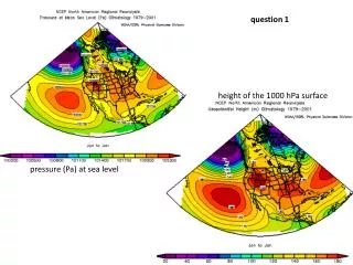
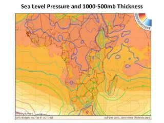
Analyzing sea level pressure and 1000-500mb thickness reveals a pattern of cyclones and storms in northern to middle Africa due to low SLP. High SLP in the southwestern region indicates calm weather. The vertical thickness increases from north to south Africa, reflecting warm air temperatures, while it decreases in the southwestern area, signifying cold air.

E N D
From the analysis low SLP intensifies from the northern to the middle parts of Africa therefore cyclone and storms are expected to the surface. • High SLP Is expected to intensify from South western side, in this area calm weather will be expected. • The vertical thickness also intensifies from north to the south Africa which shows warm air temperature. • Where as in the south western following the high pressure area the vertical thickness decreases which shows cold air.