Multicell Storms
Multicell Storms. METR 4433: Mesoscale Meteorology Spring 2006 Semester Adapted from Materials by Drs. Kelvin Droegemeier, Frank Gallagher III and Ming Xue School of Meteorology University of Oklahoma. Multicellular Thunderstorms.


Multicell Storms
E N D
Presentation Transcript
Multicell Storms METR 4433: Mesoscale MeteorologySpring 2006 SemesterAdapted from Materials by Drs. Kelvin Droegemeier, Frank Gallagher III and Ming XueSchool of MeteorologyUniversity of Oklahoma
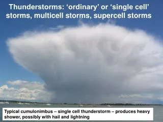
Multicellular Thunderstorms • So far we have discussed the structure of air mass or single cell thunderstorms. • We can think of these types of storms as a single “cell” where each cell is: • Independent • Has a complete life cycle • Has a life cycle of 30 minutes to an hour • Is usually weak
Multicellular Thunderstorms • We know that many thunderstorms can persist of longer periods of time. • These storms are made up of many cells. • Each individual cell goes through a life cycle but the group persists. • These storms are called multicellular thunderstorms, or simply multicells • Multicellular storms consist of a series of evolving cells with each one, in turn, becoming the dominant cell in the group.
Multicell Storms • Multicell cluster storm - A group of cells moving as a single unit, often with each cell in a different stage of the thunderstorm life cycle. Multicell storms can produce moderate size hail, flash floods and weak tornadoes. • Multicell Line (squall line) Storms - consist of a line of storms with a continuous, well developed gust front at the leading edge of the line. Also known as squall lines, these storms can produce small to moderate size hail, occasional flash floods and weak tornadoes.
Multicell Storm Weather • Multicell severe weather can be of any variety, and generally these storms are more potent than single cell storms, but considerably less so than supercells, because closely spaced updrafts compete for low-level moisture. • Organized multicell storms have higher severe weather potential, although unorganized multicells can produce pulse storm-like bursts of severe events.
Multicellular Thunderstorms With air mass storms, the outflow boundaries are usually too weak to trigger additional convection. In multicell storms, the outflow boundary does trigger new convection. Cell #1 Mature
Multicellular Thunderstorms With air mass storms, the outflow boundaries are usually too weak to trigger additional convection. In multicell storms, the outflow boundary does trigger new convection. Cell #2 Cumulus Cell #1 Mature
Multicellular Thunderstorms After about 20 minutes or so, the second cell becomes the dominant cell. Cell #1 is now dissipating, and a new cell (#3) is starting. Cell #2 Mature Cell #1 Dissipating Cell #3 Cumulus
Multicellular Thunderstorms After about 20 minutes or so, the third cell becomes the dominant cell. This process may continue as long as atmospheric conditions are favorable for new convection. Cell #2 Dissipating Cell #3 Mature Cell #4 Cumulus Cell #1 Almost Gone
Multicellular Thunderstorms • A cluster of short lived single cells. • Cold outflow from each cell combines to form a much larger and stronger gust front. • Convergence along the gust front tends to trigger new updraft development. This is the strongest in the direction of storm motion. • New cell growth often appear disorganized to the naked eye.
This illustration portrays a portion of the life cycle of a multicell storm.As cell 1 dissipates at time = 0, cell 2 matures and becomes briefly dominant. Cell 2 drops its heaviest precipitation about 10 minutes later as cell 3 strengthens, and so on.
n-2 n-1 n Life Cycle of Multicell Storms n+1
A closer view at T = 20 minutes (from in the earlier slide) shows that cell 3 still has the highest top, but precipitation is undercutting the updraft in the lower levels. New echo development is occurring aloft in cells 4 and 5 in the flanking line, with only light rain falling from the dissipating cells 1 and 2 on the northeast side of the storm cluster. • The inset shows what the low-level PPI (plane-position indicator) radar presentation might look like. This storm appears to be unicellular but the several distinct echo tops tell us otherwise.
A Real Example of Multicell storm • Here is a real storm, with radar superimposed. Observe the physical similarities to the previous slide. This Texas Panhandle storm was non-severe. Looking north-northeast from about 20 miles. Note that the updraft numbering is reversed.
Multicell Storm on Radar • Radar often reflects the multicell nature of these storms, as seen with the central echo mass and its three yellowish cores in the lower portion of this picture. • Occasionally, a multicell storm will appear unicellular in a low-level radar scan, but will display several distinct tops when a tilt sequence is used to view the storm in its upper portion This one might also contain multiple cells 4 cells
Multicellular Thunderstorms • Conditions for development • Moderate to strong conditional instability • Once clouds form, there is a significant amount of buoyant energy to allow for rapid cloud growth • Low to moderate vertical wind shear • Little clockwise turning
Importance of Vertical Wind Shear • Single cell • Weak shear - storm is vertically stacked • Outflow boundary may “outrun” the motion of the storm cell • New storms that develop may be too far from the original to be a part of it • Multicell • Weak to moderate shear keeps gust front near the storm updraft – triggers new cells • New development forms adjacent to the older cells and connects with the old cell
A Schematic Model of a Thunderstorm and Its Density Current Outflow Downdraft Circulation - Density Current in a Broader Sense (Simpson 1997)
Multicellular Thunderstorms • On the previous diagram, there are two arrows that show the “cell motion” and the “storm motion.” • Notice that they are different. Why? • New cells tend to form on the side of the storm where the warm, moist air at the surface is located. • In the central Plains, this is often on the south or southeast side. 1 1 2 Average Wind Warm, Moist Surface Air (inflow)
Cell Motion versus Storm Motion • Cells inside a storm (system) do not necessarily move at the same speed and/or direction as the overall storm system • The storm system can move as a result of the successive growth and decay of cells • It can also move because the cell motion • Environmental winds can have significant influence on the cell and/or storm movement, but the storms do not necessarily follow the wind.
Multicellular Thunderstorms • Individual cells typically move with the mean (average) wind flow • The storm system moves differently – by discrete propagation • Multicell storms may last a long time. They constantly renew themselves with new cell growth.
The growth of a multicell storm Height (3-12km) Time (0-21min)
Multicellular Thunderstorm Hazards • Heavy rain -- Flooding • Wind damage • Hail • Lightning • Tornadoes -- Usually weak • Multicell storms are notorious for heavy rain and hail
Cell Generation in Multicell storms • Before we discuss the cell regeneration in multicell storms, we will first look the gust front dynamics, which plays an important role in long-lasting convective systems • We’ll now begin to use some of what we learned in vorticity!
A Schematic Model of a Thunderstorm and Its Density Current Outflow Downdraft Circulation - Density Current in a Broader Sense (Simpson 1997)
At the surface, the cold pool propagates in the form of density or gravity current Laboratory Current Fresh Water Note lobe & cleft structures Salt Water “Haboob” in the Sudan
Other Geophysical Density Currents(Lava flow on Surtsey, Iceland 1963)
Schematic of a Thunderstorm Outflow(Goff 1976, based on tower measurements) Rotor
Vorticity Dynamics • The equation for relative vertical vorticity Tilting Advection Solenoidal Local Derivative Of Relative Vorticity Stretching/Convergence Recall Absolute Vertical Vorticity
Vorticity Dynamics • The vector vorticity equation for absolute vertical vorticity Friction Solenoidal Tilting Material Derivative Of Absolute Vorticity Stretching/Convergence
Vorticity Dynamics • Can derive the same equation for horizontal vorticity – to apply to the horizontal rotor at the head of the gust front • In it, the solenoidal term is exactly the same form but acts in the horizontal • Now, recall circulation…
Circulation Dynamics Definition of Circulation Via Stokes’ Theorem
Circulation Dynamics Mitchell and Hovermale (1977)
Gust Front Propagation • The low-level-inflow-relative speed of gust front often to a large extend determines the propagation of the storm system. This is almost certainly true for 2-D squall lines. Therefore the determination of gust front speed is important. • Gust front/density currents propagate due to horizontal pressure gradient across the front – created mainly by the density difference across the front.
Gust Front Propagation Speed – How to Determine It? • For an idealized density current shown above, we apply simple equation • What have we neglected? Friction, Coriolis effect, effect of vertical motion • Now, to simplify the problem, let’s look at the problem in a coordinate system moving with the gust front. In this coordinate system, the density current/gust front is stationary, and the front-relative inflow speed is equal to the speed of the gust front propagating into a calm environment. • We further assume that the flow is steady in this coordinate system, a reasonably valid assumption when turbulent eddies are not considered. Therefore
Gust Front Propagation Speed • Integrate the steady momentum equation along a streamline along the lower boundary from far upstream where u = U and p' = 0 to a point right behind the gust front where u=0 and p'=Dp: • The above is the propagation speed of the gust front as related to the surface pressure perturbation (Dp) associated with the cold pool/density current.
Gust Front Propagation Speed • This equation is very simple. The contributions to the surface pressure perturbation from upper-level heating, nonhydrostatic effect (vertical acceleration) and dynamic pressure perturbation can all be included.
Gust Front Propagation Speed • If we assume that the Dp is purely due the hydrostatic effect of heavier air/fluid (r = r0 + Dr) inside the cold pool of depth h (other effects as listed in the previous slide are neglected), the above formula can be rewritten as (assuming pressure perturbation above the cold pool is zero): • In this case, the speed of density current is mainly dependent on the depth of density current and the density difference across the front, not a surprising result. • When other effects are included, the speed can be somewhat different. But it is generally correct to say that deeper and/or heavier (colder) density current/cold pool propagates faster.
Laboratory Current Turbulent Laminar
Numerical Simulations Temperature’ Pressure’ Horizontal Wind Droegemeier and Wilhelmson (1987)
Numerical Simulations Droegemeier and Wilhelmson (1987)
Pressure perturbations ahead of the gust front • In the previous idealized model in the front-following coordinate, the inflow speed decreases to zero as the air parcel approaches the front from far upstream. There must be horizontal pressure gradient ahead of the gust front to ahead of the gust front and this positive pressure perturbation has to be equal to that produced by cold pool. • We can rewrite the earlier equation as • is constant along the streamline following the lower boundary which is a special form of the Bernoulli function (with the effect of vertical displacement excluded).
Numerical simulation of density currents showing the pressure perturbations associated with density current