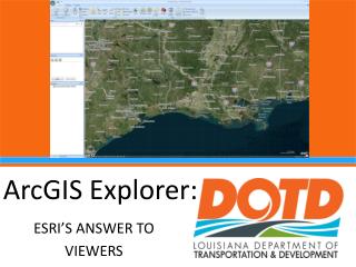
Download

1 / 4
70 likes | 526 Vues
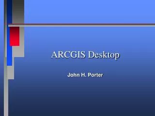
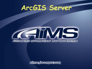
E X T E N S I O N S. ArcGIS Engine. E X T E N S I O N S. ArcGIS clients. Custom application. ArcInfo. ArcEditor. What is ArcGIS?. ArcView. ArcReader. ArcPad. Web browser. ArcGIS Desktop. Components. ArcObjects. Networks. ArcIMS. ArcGIS Server. ArcSDE.

E N D
E X T E N S I O N S ArcGIS Engine E X T E N S I O N S ArcGIS clients Custom application ArcInfo ArcEditor What is ArcGIS? ArcView ArcReader ArcPad Web browser ArcGIS Desktop Components ArcObjects Networks ArcIMS ArcGIS Server ArcSDE Application/Data Servers RDBMS
What is ArcGIS?ArcGIS is the name used to identify ESRI’s flagship family of GIS products. ArcGIS includes: • ArcGIS clients software • ArcGIS components • ArcGIS Application and data server software. ArcGIS itself is not a GIS application; rather, it is a set of software products for building ArcGIS systems that best suit your GIS needs ArcGIS is based on a common library of shared GIS software components, called ArcObjects ArcGIS is composed of client and server applications. Each software application can create, manage, analyze, and serve data stored in one or more formats
ArcGIS Desktop: Integrated suite of advanced GIS applications consisting of three software products:1) ArcView2) ArcEditor 3) ArcInfo The ArcGIS Desktop applications provide the same core mapping, editing, and analysis functionality. The level of functionality available differs depending on which license you have. ArcInfo provides users with the most complete level of GIS functionality. It is composed of ArcInfo Desktop and ArcInfo Workstation. ArcMap is the data visualization and analysis application for the ArcGIS Desktop software. ArcReader Allows users to view high-quality published maps (PMFs) created in ArcMap
ArcGIS Engine: Developer toolkit of embeddable GIS components for building custom stand-alone applications using COM, C++, Java, and NET. ArcPad: Used with PDAs for creating and managing data while in the field ArcGIS Server: A sharedlibrary of GIS software objects used to build and develop server-side GIS applications in enterprise and Web computing frameworks. ArcIMS: Used to publish maps, data, and metadata through open Internet protocols. ArcSDE: Manages and serves spatial information from external RDBMs to ArcGIS clients.