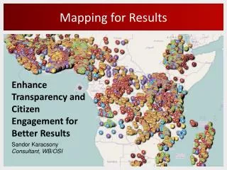
Mapping for Results
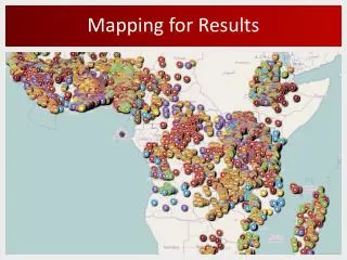
Our comprehensive mapping initiative has successfully charted over 30,000 locations for more than 2,500 active bank projects across all 143 IBRD and IDA countries. We provide indicator data on infant mortality, maternal health, and malnutrition for 43 countries, while also offering sub-national poverty and population density data for 30 and 107 countries, respectively. Our tools empower citizens through open data and innovative use of ICT, enhancing transparency and public service delivery. Explore projects in Nigeria, Ghana, DRC, and Zambia through our geo-information platforms.

Mapping for Results
E N D
Presentation Transcript
More than 30,000locations mapped for over 2,500active Bank projects For all 143IBRD and IDA countries Indicator data on infant mortality, maternal health, malnutrition for 43countries; Sub-national poverty data for 30countries Population density data for 107countries All Bank-financed projects mapped
e-ISR in Nigeria: Fadama III • Mapped 18 e-ISR Projects in 4 Countries: • Ghana • Nigeria • DRC • Zambia
Empowering citizens • Local Geographic Information makes data relevant to citizens • Open Data on aid and public service delivery increases transparency • Innovative uses of ICTs empowers citizens to better information with citizens
maps.worldbank.org SorenGigler(bgigler@worldbank.org) Johannes Kiess (jkiess@worldbank.org) KaushalJhalla(kjhalla@worldbank.org) Charles Brigham (cbrigham@worldbank.org) HanifRahemtulla(hrahemtulla@worldbank.org)