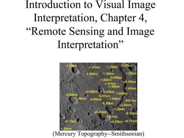
Exploring Landscape Interpretation: Glacial and Geological Features from Mountains to Valleys
This task involves the analysis of various landscapes depicted in the provided images, from the Blue Ridge Mountains to the rugged Alps. Each image is accompanied by questions designed to prompt critical thinking about physical geography and geological processes. Participants will explore differences in landscape shapes, the nature of rock formations, and the impact of glaciers on terrain. The session encourages reflection and discussion regarding the influences of weathering and glaciation, facilitating a deeper understanding of Earth's dynamic processes.


Exploring Landscape Interpretation: Glacial and Geological Features from Mountains to Valleys
E N D
Presentation Transcript
Landscape image interpretation task • View the images in each of these slides. • There is a question beneath each image – attempt to answer each one. • Note down your answers so that you can review them later or use them as part of a class discussion.
Blue Ridge Mountains, South Carolina, USA The Alps (Switzerland) http://commons.wikimedia.org/wiki/File:Blue_Ridge_Mountains_at_Tamassee,_South_Carolina.jpg?uselang=en-gb http://commons.wikimedia.org/wiki/Matterhorn#mediaviewer/File:Valais_mountains.jpg Ignoring the fact that one of the images has snow and ice in it and the other does not, What differences do you notice in the shapes of the two landscapes?
http://commons.wikimedia.org/wiki/File:Weathering_freeze_thaw_action,_Spain.jpg?uselang=en-gbhttp://commons.wikimedia.org/wiki/File:Weathering_freeze_thaw_action,_Spain.jpg?uselang=en-gb Luis Paquito http://commons.wikimedia.org/wiki/File:Shingle_Beach_-_geograph.org.uk_-_580940.jpg?uselang=en-gb Anne Burgess Why are the rocks sharp and jagged in the mountain photo and smooth and rounded at the beach?
Grand Teton National Park, Wyoming, USA DEA The sharp edged, angular rocks on this slope are called pieces of ‘scree’ (or ‘talus’). Can you think of what ‘physical weathering’ process has broken up the rock into these pieces? And how does it work?
Blue Glacier, Olympic Range, Washington State, USA http://commons.wikimedia.org/wiki/File:Mount_Olympus_Blue_Glacier_from_Lateral_Moraine_Panorama.jpg?uselang=en-gb Aaron Linville Notice the rocky debris along the sides of this glacier (called ‘lateral moraine’) Viewed close up, the pieces of rock would be jagged and angular as in the previous photo. Where has this rocky debris come from, and how do you think it got to the glacier?
A photo looking underneath a glacier http://www.swisseduc.ch/glaciers/glossary/glacier-sole-en.html J.Alean & M.Hambrey How do you think pieces of rock debris can get picked up by the glacier as it moves over the ground? Hint: there is melting and refreezing of water beneath glaciers.
http://commons.wikimedia.org/wiki/File:Glacial_striations.JPG?uselang=en-gbhttp://commons.wikimedia.org/wiki/File:Glacial_striations.JPG?uselang=en-gb These scratches (glacial ‘striations’) formed in the past when a glacier was in this valley. Can you describe the process that caused the scratches on this rock outcrop? Hint: glaciers move rocky debris inside and under them as well as along the surface.
http://commons.wikimedia.org/wiki/File:V-shaped_valley_below_Craig_y_Gath_-_geograph.org.uk_-_811259.jpg?uselang=en-gbhttp://commons.wikimedia.org/wiki/File:V-shaped_valley_below_Craig_y_Gath_-_geograph.org.uk_-_811259.jpg?uselang=en-gb Rudi Winter One of these valleys was eroded out by a glacier. Describe the shapes of the two valleys and suggest reasons for the difference. http://commons.wikimedia.org/wiki/File:U-Shaped_valley,_Glen_Clova_-_geograph.org.uk_-_477230.jpg?uselang=en-gb Gwen and James Anderson
Hummocky moraine in north-west Scotland DEA Describe the shape of the piles of rocky debris in the photograph. Why do you think this can be interpreted as the work of glacier ice rather than of running water?
Whistler, British Columbia, Canada DEA What evidence is there in this photo that glaciers extended further down the mountain slopes in the past?
Snowdonia, north Wales http://commons.wikimedia.org/wiki/Snowdonia#mediaviewer/File:Snowdon_massif.jpg What evidence is there in this photo that this area used to have glaciers?