Download
1 / 22
240 likes | 386 Vues
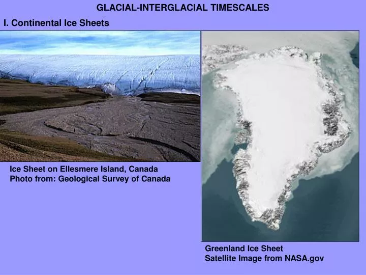
GLACIAL-INTERGLACIAL TIMESCALES. I. Continental Ice Sheets. Ice Sheet on Ellesmere Island, Canada Photo from: Geological Survey of Canada. Greenland Ice Sheet Satellite Image from NASA.gov. II. Alpine Glaciers. Alaskan Glacier, USGS photo. Lateral Moraine. Medial Moraine. U-shaped Valley.

E N D
GLACIAL-INTERGLACIAL TIMESCALES I. Continental Ice Sheets Ice Sheet on Ellesmere Island, CanadaPhoto from: Geological Survey of Canada Greenland Ice Sheet Satellite Image from NASA.gov
II. Alpine Glaciers Alaskan Glacier, USGS photo Lateral Moraine Medial Moraine U-shaped Valley
U-shaped Valley Boggs. Principles of Sedimentology and Stratigraphy. 4th Edition, p 279.
Arete Cirque Meltwater Lake Alaskan Glacier, USGS photo
M7.9 Earthquake on Denali Fault, November 3, 2002 / Stitched 2022_2023Photos by R. March and D. Trabant, USGS Glaciology, Fairbanks, AK11/7/2002
Glacial Environments and Timescales Boggs. Principles of Sedimentology and Stratigraphy. 4th Edition, p 277.
Till Mt. Ranier, WA Boggs. Principles of Sedimentology and Stratigraphy. 4th Edition, p 282.
Kettles: form during Glacial Retreat as block of ice are stranded in surrounding outwash and then melt. Often associated with Kames: piles of sediment that accumulate in a depression on a retreating glacier, that then melts. Isolated Blocks of Glacial Ice U.S. Geological Survey photo by Bruce Molnia
Esker in Northern Manitoba. A Natural Resources Canada image Ice Flow Direction Drumlin near Calgary
Ice Flow Direction Image created by Dr. Richard AllmendingerEarth and Atmospheric Sciences, Cornell University
Glacial/Interglacial Timescales Orbital Variations (Ruddiman, 2001)
“Milankovitch cycles” Variations every 20,000 to 100,000 years (aka “orbital cycles”)
1 meter rise 2 meter rise 4 meter rise 8 meter rise From: www.gfdl.noaa.gov
From: http://www.uwgb.edu/dutchs/EarthSC202Notes/GLACgeog.HTM From: http://www.mvd.usace.army.mil/mrc/images/p1_new.jpg
Glacial Processes in New Hampshire (Van Diver, 1987)
Drumlins • Kame Terraces • Moraines • Outwash Deposits • Erratics • Striations • Kames and Kettles (Van Diver, 1987)
Sheepback or Roche moutonnée Mountain Scale (Van Diver, 1987) Outcrop Scale Roche moutonnée, northern Abitibi, Québec, from Geological Survey of Canada
Erratics (Van Diver, 1987)
Glacial Lakes Marine Submersion (Van Diver, 1987)