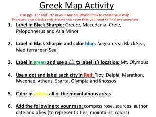

China Map Activity
E N D
Presentation Transcript
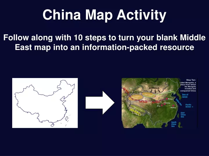
China Map Activity Follow along with 10 steps to turn your blank Middle East map into an information-packed resource
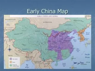
China Map Activity This activity will identify cities, landmarks, and the locations of geographic and man-made features that helped to keep China isolated from the rest of the world in ancient and medieval times.
Start with this blank Middle East map, and follow along with the next 15 steps
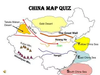
Step One: Label these bodies of water, which helped keep China isolated from the west Sea of Japan Yellow Sea Pacific Ocean East China Sea South China Sea
Step Two: Label and lightly shade in the Gobi Desert, which helped to keep China isolated from the North Gobi Desert Sea of Japan Yellow Sea Pacific Ocean East China Sea South China Sea
Step Three: Label and lightly shade in the TaklaMakan Desert, which helped to keep China isolated from the East Gobi Desert Sea of Japan TaklaMakan Desert Yellow Sea Pacific Ocean East China Sea South China Sea
Step Four: Label and lightly shade in the Plateau of Tibet, which helped to keep China isolated from the South Gobi Desert Sea of Japan TaklaMakan Desert Yellow Sea Pacific Ocean Plateau of Tibet East China Sea South China Sea
Step Five: Draw triangles to represent the Himalayas, which helped to keep China isolated from the South Gobi Desert Sea of Japan TaklaMakan Desert Yellow Sea Pacific Ocean Plateau of Tibet Himalayas East China Sea South China Sea
Step Six: Draw and label the Great Wall, which helped to keep China isolated from the North Great Wall of China Gobi Desert Sea of Japan TaklaMakan Desert Yellow Sea Pacific Ocean Plateau of Tibet Himalayas East China Sea South China Sea
Step Seven: Draw and label the Silk Road, which brought travelers like Marco Polo Great Wall of China Silk Road Gobi Desert Sea of Japan TaklaMakan Desert Silk Road Silk Road Yellow Sea Pacific Ocean Plateau of Tibet Himalayas East China Sea South China Sea
Step Eight: Label and STAR Beijing, the current Chinese capital Great Wall of China Silk Road Gobi Desert Sea of Japan TaklaMakan Desert Beijing Silk Road Silk Road Yellow Sea Pacific Ocean Plateau of Tibet Himalayas East China Sea South China Sea
Step Nine: Label and STAR three other cities that were capitals for various Chinese dynasties Great Wall of China Silk Road Gobi Desert Sea of Japan TaklaMakan Desert Beijing Silk Road Silk Road Yellow Sea Luoyang Pacific Ocean Xi’an Nanking Plateau of Tibet Himalayas East China Sea South China Sea
Step Ten: Label Mongolia, a place from which the Mongols invaded and conquered China MONGOLIA Great Wall of China Silk Road Gobi Desert Sea of Japan TaklaMakan Desert Beijing Silk Road Silk Road Yellow Sea Luoyang Pacific Ocean Xi’an Nanking Plateau of Tibet Himalayas East China Sea South China Sea
MONGOLIA Great Wall of China Silk Road Gobi Desert Sea of Japan TaklaMakan Desert Beijing Silk Road Silk Road Yellow Sea Luoyang Pacific Ocean Xi’an Nanking Plateau of Tibet Answer this question on the back: 1) Why was China so isolated during ancient times and the Middle Ages? Himalayas East China Sea South China Sea
MONGOLIA Great Wall of China Silk Road Gobi Desert Sea of Japan TaklaMakan Desert Beijing Silk Road Silk Road Yellow Sea Luoyang Pacific Ocean Xi’an Nanking Plateau of Tibet Answer this question on the back: 2) How do you suppose the Mongols were so successful in conquering China for a period of time? Himalayas East China Sea South China Sea