Download
1 / 41
410 likes | 635 Vues
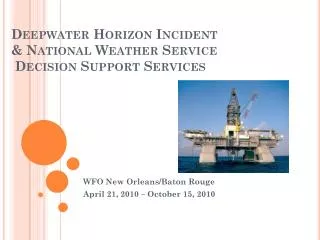
Deepwater Horizon Incident & National Weather Service Decision Support Services . WFO New Orleans/Baton Rouge April 21, 2010 – October 15, 2010. The Event.

E N D
Deepwater Horizon Incident& National Weather Service Decision Support Services WFO New Orleans/Baton Rouge April 21, 2010 – October 15, 2010
The Event • On the night of April 20, 2010, the semi-submersible production petroleum platform “Deepwater Horizon” exploded during a drilling operation. • After burning intensely for 36 hours, the rig sank on the 22nd, resulting in a massive oil spill from the ruptured well head. • Well head located 5000 feet deep over the Macondo Dome on the edge of the Continental Shelf. • Macondo Well over 18,000 feet deep.
WFO New Orleans/Baton Rouge (LIX) Engagement • The office received a call from the U.S. Coast Guard, notifying us of the incident shortly after the initial explosion. • USCG requested a detailed weather forecast for the location – Mississippi Canyon 252 oil lease area, Lat 28.74N and Lon 88.44W. • The NOAA Office of Response and Restoration (OR&R) requested the initial spot forecast on April 21st. • The Spot Forecast would be produced twice a day for much of the entire incident response.
Deploying to Incident Command • Not automatic!!! • ‘Not needed’ initially by BP • Had to gain trust and prove performance • Rapport with USCG and other federal agencies was key.
Battle Rhythm • Started out a 24 hour cycle • Around day 75 – 2 day cycle • Around day 98 – 4 day cycle • After static kill - a 7 day cycle
Organizational Chart (an example) NWS and NOAA
Multiple Aspects of Forecasting • Aviation • Low level dispersion flights • 2nd level spotter flights • Mid-level reconnaissance flights • Terminal forecasts for non-TAF locations • Hancock County-Stennis Airport (MS) • Terrebonne-Houma Regional Airport (LA) • Marine • Near shore in protected and unprotected waters • Offshore spill location (62nm from mouth of the MS River) • Wave steepness, swells, period, source regions • Fire Weather • In-situ burning of oil on water (able to smell at WFO) • Heat Stress • Oil clean-up in Tyvek protective covering during summer • Outsider assistance not accustomed to Gulf humidity
Multi-layered Aviation • Over flights • Reconnaissance • Dispersant Flights • Use of tstm outflow boundaries • VIP over flights • Animal/Wildlife search and rescue
Decision Support Modifications • Emergency TAFs for staging airfields • Terrebonne-Houma Regional Airport, Houma, LA • Incident Command Center location • Overflight and surveillance flight operations • Hancock County – Stennis Airport, Stennis, MS • Military dispersant flight staging • Government VIP staging • Presidential Visit toVenice, LA • “Synthetic” TAF temporarily established for Boothville-Venice ASOS location to support POTUS logistics. • Other direct support
Multi-national effort • Canadian Coast Guard and Icelandic Coast Guard • SLAR over flights for intelligence gathering on daily spill footprint. • Weather sensitive for winds and seas
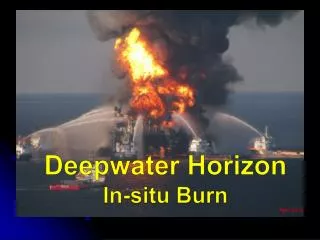
In-Situ Burns • Not your typical wildfire or prescribed burn • Critical operating levels based on wind direction and sea state • Main motivation for the hourly spot forecasts issued every day by WFO LIX
Aviation Weather Briefings • Most operations were heavily dependent on weather decision support • Most often weather was the GO/NO GO factor on a daily basis
Marine Support Deepwater fleet – many vessels in tight operations area Vessels of Opportunity (VOO) Fleet Boom Deployment near shore
Intelligence Gathering • WFO LIX prepared a daily overflight forecast to aid in satellite imaging data quality
Heat Stress • Very critical factor to beach cleaning limitations • 40-20 rule and 20-40 rule • No Tyvek covering • 40 minutes each hour, 20 minutes of supervised rest in a tent. • Full Tyvek protection • 20 minutes work each hour, 40 minutes of supervised rest in a tent. • Numerous Heat Advisory Days during the episode • Most event related injuries/illness were heat stress related (about 40% of all reportable injuries).
Tropical threats • Tropical Storm Bonnie • July 23-25 • A direct threat to the area of operations • Weakened before moving over operations area • Prompted a 3 day shut-down of operations at the source • A 1 day Shelter-in-place stand down at Houma ICC.
Tropical threats • Tropical Depression Five • August 10-11 • A direct threat to the area of operations • Dissipated before making landfall • Still prompted a 3 day shut-down of operations at the source • A 1 day stand-down, shelter in place at Houma ICC.
NOAA Line Office Collaboration • NOS - Office of Coast Survey • Oil Trajectory forecast maps produced daily • NOAA – Office of Response and Restoration • Initiated 2-a-day spot forecast requests • Frequent teleconference weather briefings • NOS / USCG weather briefings for decon operations
Incorporating Science and Technology • Trajectories • Loop Current interactions • Tropical Wx interactions • Dispersant behavior
Multiple levels of government • NWS Director Jack Hayes visits the Incident Command Center in Houma, LA, pose in front of the LA GOHSEP response vehicle. • Pictured from left, • ER-Met Tim Erickson (WFO LIX) • NWS Director Hayes, • ER-Met Mike Efferson (WFO LIX) • Kenneth Graham, WFO LIX MIC • Not pictured – LA State Police response vehicle next to GOHSEP. • Heavy parish/county EOC presence.
Media Interviews and briefings • Oil vs Hurricanes; Hurricanes and oil • Talking points generated by WFO LIX/NHC/WSH/NOAA. • Formal briefings: approximately 1200 • Informal briefings: approximately 5000 • International, national and local media interviews: 150 • Often became overwhelming from a workload standpoint. • Recommend bringing in a Public Affairs or HQ person to handle interviews. • MIC spoke at press conference with Alabama governor. • MIC on panel at 4 NOAA town hall meetings.
Meanwhile, Back at the office • Initiated the ER-Met Desk • Two event coordinators appointed by MIC • 24 hr coverage – 2 twelve hour shifts • Fire Weather Spot Forecast formatter modified • In addition to traditional grid based parameters… • TAFs for aviation ops staging terminals • 3 day Areal Aviation Outlook • Sounding data to support in-situ burning ops • Tide information • Radar summary • Watch/Warning/Advisory Summary • Issued hourly from 0500 to 1900
Making it work • Enacted an emergency schedule to account for 4 forecasters out of the regular rotation • National and regional assistance with back fill staffing • All product templates were developed ‘on-the-fly’ to meet specific forecast needs • Back-fill staff contributed greatly to the success of this undertaking by bringing skills and best practices into the local operations! • Web page presence developed at WFO LIX by intern Shawn O’ Neil (pictured above). Linked on White House website.
Hourly spots • Originally generated for the spill location • NOS – OCS requested two shore-based spot forecasts for shoreline clean up and harbor boom deployment • Port Fourchon spot for waters west of the MS River • Hopedale spot for the LA sounds east of the MS River • Issued from 0400 through sunset each day • Sensitivities with LOOP facilities serviced out of Port Fourchon, LA • Last hourly spot issued Aug 24th • 3,920 hourly spots issued for entire event.
Across the board contributions • Virgil Middendorf – WFO Boise, ID • Assisted greatly with Spot Forecast formatter modifications • Angel Montenez – WFO Birmingham, AL • Added and modified grid fields and AWIPS workfiles to facilitate Spot Forecast generation • WSH Office of Hydrology • Provided scripting to parse tide data from RiverPro hydro database • SRH – brought in team to make local Active Directory work more efficiently.
Back fill Contributions • 44 forecasters TDY to WFO LIX; others to MOB. • IMETs deployed to Forward Operations Base (FOB) in Venice, LA • IMET briefly deployed to Houma ICC • ICS role not well suited to typical Fire IMET functions • Lack of familiarization with local environment and government landscape • Different weather regime - heavily marine oriented • Tide tables developed by back fill (HGX) • GIS based gridded data developed by LCH back fill (also assisted in emergency relief at ICC)
GIS generated graphics • Expedited GIS programming provided by • WFO LCH Service Hydrologist – Jonathan Brazzell and • LMRFC DOH – David Welch • Initial hardware challenges • Produced automatically by cron on local GIS box; posted to web
Web Page Development • Originally posted basic information and forecasts to existing EM briefing page. • Intern with web design skills added thumbnails and Google maps capabilities. • Page was posted on Whitehouse.gov site • Became the ‘go-to’ page for NWS spill response • Hit count: 102,838 thru 10/7/10. • Seen on EOC screens www.srh.noaa.gov/lix/?n=embriefing
Graphic forecast • FXC generated animated graphicast • Encompassed the entire area of response (TX-FL) • Used extensively by the ICC, UAC and NOAA Hazmat • Posted on the DWH web page.
Severe Weather Surveillance • From April 22 – Oct 09 • 22 Tornado Warnings • 112 Severe Thunderstorm Warnings • 358 Special Marine Warnings • 26 Flood/Flash Flood Warnings • 518 Total warnings during event • Challenging for some visitors
NWSEO Role • LOT efforts to implement emergency schedule • Some concessions to accommodate deployed and back-fill transitions • NWSEO President visited the WFO LIX and toured Houma ICC on August 12th.
Simultaneous Incident responses Mar 30 (pre-spill): Denham Springs Petroleum Warehouse Fire Sep 2: Another Rig explosion south of Cameron, LA July 30: Mud Lake in Barataria Bay pipeline leak Aug 10: Norco Motiva Sulfuric Acid leak Aug 9: New Orleans East train derailment – 19 cars involved Aug 12: Paincourtville, Assumption Parish, LA gas leak (108 spots issued)
Continuity of Operations (COOP) • Instructions and templates posted to SRH Sharepoint • NWSChat used extensively • Deepwateroilchat room established early on and exclusively for Gulf NWS offices only and ICC/ICP. • NDBC was added to NWSChat and utilized for buoy data quality collaboration. • Cross training with office visits from WFO MOB personnel. • Back fill mets exposed to ICS activities • Most visited the Houma ICC (brief security hault)
Miscellaneous Factors • Fatigue (awards, food, quotes, visits helped) • Long days (12-15 hours, some longer 4/10 – 6/10) • Fast paced • Not the typical NWS routine • Many consecutive days without a break • Areal familiarity crucial • Ability to be flexible • Readiness for other responses • Tropical Weather Staff training/drills/outreach • Other “routine” operations
Future Considerations • Decision Support Services need… • Turnkey approach to forecast product formatters • Portability for ICC or UAC deployment • Flexibility in policies and protocols to best fit the situation • DSS should have robust GIS capabilities and fully integrated data sources. • ER-Mets not equivalent to IMET in skill sets for all situations • Staffing Area Command • FOB – IMETs • ICC – local WFO • UAC – RH or WSHQ • Equipment should be prepared and ready prior to deployment (Active Directory and security issues)
Summary • Largest emergency Response in U.S. History • Deepwater Horizon Rig Explosion and ensuing massive oil spill. • NWS was a key component of federal response, along with other NOAA line offices. • Local WFOs provided critical and unprecedented Decision Support Services for their respective AOR.
Contact Information • Kenneth Graham, MIC • kenneth.graham@noaa.gov • 985-645-0565, extension 222 • Robert J. Ricks, Jr. • robert.ricks@noaa.gov • 985-645-0565, ext 4 • www.weather.gov/neworleans Thank You!