Reading a Weather Map
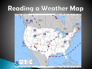
Reading a weather map involves understanding isobars, which connect places of equal air pressure. When these lines are close together, wind strength increases. High-pressure areas, marked by sinking air, generally bring fine weather, with winds rotating anticlockwise. In contrast, low-pressure areas, characterized by rising air, usually result in cooler weather and rain, with clockwise wind rotation. Fronts indicate temperature changes, with cold fronts causing drops in temperature and rain, while warm fronts lead to rising temperatures and occasional light rain.

Reading a Weather Map
E N D
Presentation Transcript
Isobars Join places of same air pressure. The closer together these lines, the stronger the wind.
High Pressure Area Sinking Air Generally fine weather. Winds rotate around these areas anticlockwise.
Low Pressure Area Rising Air Generally cooler weather, rain. Winds rotate around these areas clockwise.
Tropical Cyclone Rapidly Rising Air Strong winds, torrential rain.
Cold Front The ‘line’ along which an approaching mass of cold air meets warmer air. Fall in temperature, rain. Front moves in direction of arrowheads.
Warm Front The ‘line’ along which an approaching mass of warm air meets colder air. Temperature rise, sometimes light rain. Uncommon in Australia.
Rain Rain in the last 24 hours Usually associated with low pressure areas and fronts.