Map Reading
Map Reading. Map Reading. Learning Outcome 3: Be able to plan routes using Ordnance Survey map features and contour lines. Visualising the shape of the land. Visualising the shape of the land. Contour Lines. Contour lines link points of equal height on the map at ten metre intervals.


Map Reading
E N D
Presentation Transcript
Map Reading Learning Outcome 3: Be able to plan routes using Ordnance Survey map features and contour lines
Contour Lines • Contour lines link points of equal height on the map at ten metre intervals. • Contours display how many metres land is above sea level.
Crag Edges Land feature Map feature
Steepness and Direction GR 289 824 facing West
Steepness and Direction GR 402 083 facing North
Lie of the land GR 878 365 facing North
Ridges, Saddles and Cols GR 176 567 facing West
Ridges, Saddles and Cols GR 973 589 facing North
Brent Knoll Brent Knoll from GR 389 552
Brent Knoll Brent Knoll from GR 349 509
Crook Peak Crook Peak from GR 378 555
Crook Peak Crook Peak from GR 371 525
What is Relief? • Means the rise and fall of the ground • Hills and Valleys • Maps show both the height and the shape of the land • How is this represented on a flat bit of paper though?
How is it shown? • Spot heights – dots on a map that show the height at that point • Layer Tinting, which represents a height band as a colour • 3D maps • All have their drawbacks
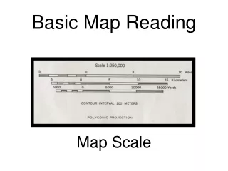
What are we going to use? • Contour lines join all points of the same height on a map • Can fairly accurately judge the shape of the land • Check the units of elevation though!!!!
So how do contour lines work? • Between any 2 lines there must be a slope up or down • Continuous except at cliffs • Shown every 10m on M726 maps, with thicker lines every 50m • Heights on lines printed so that if read right way up, you are facing uphill.
Contour plans • A map view of a hill (bottom) is like looking down on it from above • If you “project” the lines from the map, you can create a side view of the hill • You need to be able to visualise this to read contour lines properly
Slopes • If 2 lines are far apart, then you have to walk a long way to gain any height • This suggests a gentle slope • If 2 lines are close together, then you don’t have to walk far to gain height • This suggests a steep slope
Slope shape • What is convex, what is concave? • The contour lines tell you the shape of a hill – the closer together they are, the steeper that part of the hill
Ridges, Saddles, and Cols • Long narrow stretch of elevated ground • Also known as a Saddle • Where a ridge joins 2 peaks, the bit in the middle is known as a Col
Ridges, Saddles, and Cols Col Summit Summit Ridge Ridge
Spurs and Re-entrants • Spur is an area of high ground which juts out into an area of low ground • Re-entrant is a narrow valley, closed at 1 end, in between 2 spurs Spur Re-entrant Spur Re-entrant
Escarpments and Knolls • Escarpments are features with sides sloping away from each other – once side being very steep, and one side being shallow. • The Downs are good examples of Escarpments • A knoll is a small isolated hill
Relief • Relief refers to the way in which height is displayed on a map. • This is shown by a system of lines called ‘Contours’.
If you were walking from Grizedale Youth Hostel to Brantwood House, by footpaths only, what different terrain would you be walking through? Finish Start
From the car park at Brackenclose describe the 2 main routes to the trig point on Scafell Pike