
Maps
Maps. Latitude & Longitude. 2D vs. 3D Maps. Main Idea 1. Each practical map contains specific indications, symbols, & keys that are vital for navigating or pinpointing an exact location. CARTOGRAPHY. What is a cartographer ? . CARTOGRAPHY. Define Cartographer :

Maps
E N D
Presentation Transcript
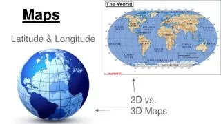
Maps Latitude & Longitude 2D vs. 3D Maps
Main Idea 1 Each practical map contains specific indications, symbols, & keys that are vital for navigating or pinpointing an exact location.
CARTOGRAPHY What is a cartographer?
CARTOGRAPHY Define Cartographer: person who specializes in making maps
LATITUDE & LONGITUDE What is latitude? What is latitude?
LATITUDE & LONGITUDE Define Latitude: imaginary lines that run horizontally on a map/globe, indicating a distance north or south of the equator Also called: Parallels 0o is called: Equator
LATITUDE & LONGITUDE What is longitude? What is longitude?
LATITUDE & LONGITUDE Define longitude: imaginary lines that run vertically on a map/globe, indicating a distance east or west of the prime meridian Also called: Meridians 0o is Called: Prime Meridian
SYMBOLS USED ON A MAP What is a compass rose? What is a compass rose?
SYMBOLS USED ON A MAP Define Compass Rose: a design on a map that indicates direction
SYMBOLS USED ON A MAP What is a compass? What is a GPS? What is a compass? What is a GPS?
SYMBOLS USED ON A MAP Direction Tools Used in Real Life Compass: Instrument used to determine direction by means of a magnetic needle pointing to magnetic north Global Positioning Satellite (GPS): Satellite signals that plot positions using coordinates (latitude/longitude).
SYMBOLS USED ON A MAP What is a scale? What is scale?
SYMBOLS USED ON A MAP Define Scale: The ratio of a distance on a map to the actual distance between locations Types of Scales 1.) Graphic: Directly shows the length of some unit of distance on a map 2.) Fractional: Gives the ratio of units on a map to units on Earth’s surface
Main Idea 2 2D maps distort distances on the 3D surface of Earth
PROJECTIONS What is a projection? What is a projection?
PROJECTIONS Define: Conversions of a 3D object into a 2D one. 2 Types of Projection: 1.) Cylindrical 2.) Planar
PROJECTIONS What is cylindrical projection? What is a cylindrical projection?
CYLINDRICAL PROJECTION Define Cylindrical Projection: Taking a 3D model of Earth and then rolling it flat. Meridians & parallels are equally spaced & perpendicular to each other.
CYLINDRICAL PROJECTION Advantage: Navigators can easily plot their compass bearings as straight lines Disadvantage: Model gets highly distorted toward the top and bottom
PROJECTIONS What is planar projection? What is planar projection?
PLANAR PROJECTIONS Define Planar Projection: Conversion of a 3D globe into a 2D map by cutting the globe in half The 2 Poles are at the center.
PLANAR PROJECTIONS Advantage: Areas at the poles are highly accurate; easier for airplane pilots to locate shorter routes. Disadvantage:Gets highly distorted towards the edges.


