Download
1 / 22
220 likes | 395 Vues
Summary of Global Tropospheric Wind Sounder (GTWS) Technology Roadmap. Ken Miller, Mitretek Systems June 23, 2003. Agenda. Purpose Vital National Need Multi-year Interagency Program Recommendation Status Reference Designs DWL Alternatives Roadmap Summary and Recommendations

E N D
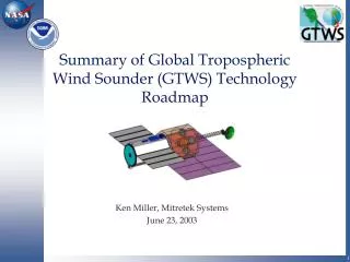
Summary of Global Tropospheric Wind Sounder (GTWS) Technology Roadmap Ken Miller, Mitretek Systems June 23, 2003
Agenda • Purpose • Vital National Need • Multi-year Interagency Program Recommendation • Status • Reference Designs • DWL Alternatives • Roadmap • Summary and Recommendations • Acknowledgments
Purpose • GTWS: Acquire global wind profiles • Roadmap: Focus GTWS activities • Draft roadmap submitted for NASA and NOAA consideration • Based on multi-agency input • High level • Important unknown factors • Resource needs will vary widely depending on approach and rate of technology progress
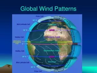
Vital National Need • Global winds are the number 1 unmet observational requirement for global weather forecasts (NPOESS IPO) • NASA Earth Science Directorate plans include global tropospheric wind observation and assimilation • Wind data will support missions of NOAA, NASA, DOD, FAA, FEMA, Department of Homeland Security • Benefits to government, industry, and citizens include • Weather forecasting • Atmospheric and climate studies • Transportation • Air quality forecasting • Shipping • Agriculture • Construction
Multi-year InteragencyProgram Recommendation • Participating agencies • Prepare a long term plan • Define appropriate agency roles • Share funding, staff, and other resource commitments • Share user benefits
Status • NOAA/NASA partnership since 2000 • Guided by GTWS Executive Steering Committee (GESC) • Investigate data acquisition • GESC action item to prepare this roadmap • Data requirements • OSSEs • Requirements validation • Benefit quantification • Favorable preliminary benefit-to-cost ratios • Reference instruments and missions • Assess technology readiness • Support evaluation of alternatives • Preliminary cost estimates • NASA Laser Risk Reduction Program (LRRP)
Status (continued) • Instrument activities • NASA, NOAA, IPO and others demonstrating ground and airborne DWLs • IPO funding airborne work on calibration/validation • Related international missions • Japanese National Space Development Agency (NASDA) • European Space Agency (ESA)
Status - Measurement Concept 7.7 km/s • Vertical resolution range gates • 45 o nadir angle • Scan through 8 azimuth angles • Fore and aft perspectives in TSV • Move scan position ~ 1 sec • No. shots averaged ~ 5 sec * prf • 4 ground tracks Aft perspective 45° 585 km 400 km 45° Horizontal TSV 414 km 7.2 km/s 290 km 290 km
Status - Instrument Concepts Belt Drive Radiator Telescope with Sunshade Rotating Deck Component Boxes Direct Radiator Component Housing Coherent Note: Large solar arrays not shown
Status - DWL Alternatives • Each alternative has advantages • Direct detection • Coherent • Hybrid • Hybrid combines complementary aspects of coherent and direct detection • Possibly the most rapid and economical approach • May complicate mission and spacecraft issues • IPO is sponsoring a hybrid DWL feasibility study
Status -Reference Designs • Need space-qualified DWL capable of meeting data requirements • Coherent and direct detection reference designs completed • Large and heavy spacecraft • Massive optical components • Very high electrical power consumption • Hybrid • Promising point design supported by IPO • Reference design not completed
Roadmap - Near Term Issues • Technology development needed • Lasers • Detectors • Low-mass telescopes • Scanners • Momentum compensation • Benefits and sensitivity to data requirements • Hybrid reference design • DWL alternatives - trade studies • Impacts on data products from atmospheric properties, DWL alternatives, and spacecraft mechanics • Calibration and validation
Roadmap • Time scale depends on • Funding and resource decisions • Technology advances • Longest lead time estimates • Flight qualified lasers – 4 years • Electro-optic scanners (alternative to rotating telescope scanners) – up to 6 years • Laboratory, ground, air, and space demonstrations will reduce risk and cost
Roadmap –Major Tasks and Phasing No time scale assigned pending planning decisions
Roadmap – Task Descriptions 1. GESC Oversight- coordinate interagency support and management 2. Data Requirements and Data Utility Preparedness • Benefits, sensitivity to data requirements • Data assimilation • Revised data requirements, if justified 3. Achieve Technology Readiness • Lasers • Detectors • Low-mass telescopes • Scanners • Momentum compensation
Roadmap – Task Descriptions (continued) 4. Architecture- system engineering and architecture for optimal design and acquisition, e.g. • Trades between data requirements and technology • Hybrid reference design • Trades between DWL alternatives • Atmosphere and lidar models • Impacts on data products from atmospheric properties, DWL alternatives, and spacecraft mechanics • Calibration and validation 5. Ground Demonstration- prototype DWLs
Roadmap – Task Descriptions (concluded) 6. Air Demonstration • Selected DWL approach • Variety of atmospheric conditions 7. Space Demonstration • Prove ability to meet data requirements from orbit • Shuttle, International Space Station, DOD Space Test Program mission, or other platform 8. Operational Mission • Acquire, launch, and operate end-to-end system • Produce and distribute data products • Orbit a second instrument, as required, to meet temporal and spatial resolution requirements
Roadmap - Preliminary Resource Estimates • Cost estimates for internal government use • Depend on a wide range of contingencies • Inference from experience is not very accurate
Roadmap – First Cut Fraction of Relative Cost by Task Fraction of total cost
Summary and Recommendations • Promising preliminary benefit to cost ratio • Requires technology advances • Architecture studies • To drive future work • Potential savings on development, space demonstration, and mission • Interagency team • Near term activities
Acknowledgments Farzin Amzajerdian (NASA/LaRC) Robert Atlas (NASA/GSFC) Wayman Baker (NOAA/NWS) James Barnes (NASA/LaRC) David Emmitt (Simpson Weather Associates) Bruce Gentry (NASA/GSFC) Ingrid Guch (NOAA/NESDIS) Michael Hardesty (NOAA/OAR) Michael Kavaya (NASA/LaRC) Stephen Mango (NPOESS/IPO) Kenneth Miller (Mitretek Systems) Steven Neeck (NASA/HQ) John Pereira (NOAA/NESDIS) Frank Peri (NASA/LaRC) Upendra Singh (NASA/LaRC) Gary Spiers (NASA/JPL) James G. Yoe (NOAA/NESDIS)