Download
1 / 12
130 likes | 300 Vues
Yanmin Shuai , Jeffrey G. Masek , Feng Gao , Crystal B. Schaaf . (2010). An Algorithm for the Retrieval of 30-m snow-free albedo from Landsat surface reflectance and MODIS BRDF , s ubmitted to RSE under reviewing. Update Landsat Albedo. Legend of modules. A. Processing chain

E N D
YanminShuai, Jeffrey G. Masek, FengGao, Crystal B. Schaaf. (2010). An Algorithm for the Retrieval of 30-m snow-free albedo from Landsat surface reflectance and MODIS BRDF , submitted to RSE under reviewing Update Landsat Albedo
Legend of modules A.Processing chain B.MODIS information C. Landsatalbedo products Landsat Surface Reflectance Algorithm Review A Unsupervised classification • Inputs: Landsat surface reflectance, MODIS BRDF parameters and QA • Outputs: spectral/broadband albedo, nadir view reflectance • Model: MODIS BRDF model (RossThick-LiSparse-R) Reprojection and aggregation B MODIS BRDF Albedo-to-Nadir Ratio Calculation MODIS QA Landsat scene Albedo generation C Landsat Broadband Albedo Landsat Spectral Albedo
PSU Albedo Upperleft: Land surface white-sky albedo composite (NIR, Red, and Green bands to RGB) Upperright: MODIS white-sky albedo composite Lowerleft: Google Maps Lowerright: scattering plot between Landsat (X-axis) and MODIS (Y-axis) albedo Area: 30km by 30km WRS-2 path 16 and row 32 (PSU site)
R2is a determination of the correlation coefficient from the linear regression using the “least square” method; Slope is the slope of regressed line.
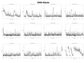
Temporal albedo over DRA site (Desert Rock, Sparse Vegetation)
Landsat Nadir BRDF-Adjustment Reflectance (NBAR) Landsat surface reflectance 4, 3, and 2 composite (Color enhancement: WRS-2 p012r031, 2002-07-31 Landsat NBAR (band 4,3,2 combination) (Note: no retrieval in the water region) NIR 0-0.5;Red 0-0.06; Green 0-0.006)
Difference between surface reflectance (directional) and nadir view reflectance Difference between directional reflectance and NBAR for Red band Difference between directional reflectance and NBAR for NIR band
Next … • Snow-covered pixels (spatial extension) • Beyond MODIS-era (temporal extension) • BRDF shapes for snow-covered surface types • BRDF shapes for typical surface types (surface type, date, NDVI, band, etc.) • Compatible land cover classification • Narrowband to Broadband conversion