Understanding Geoprocessing in ArcGIS: Definitions, Tools, and Applications
150 likes | 262 Vues
This unit explores geoprocessing in ArcGIS, emphasizing the use of computers to model, interpret, and alter geospatial data. It covers essential functions like Append, Clip, and Buffer, along with practical examples such as creating new datasets and identifying distances between features. The ArcToolbox is introduced as a critical component, offering a suite of tools that simplify geoprocessing tasks. Learners will gain insights into how to select features, manage data outputs, and troubleshoot errors effectively. Overall, this unit is vital for enhancing spatial analysis skills in GIS.

Understanding Geoprocessing in ArcGIS: Definitions, Tools, and Applications
E N D
Presentation Transcript
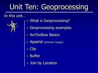
Unit Ten: Geoprocessing What is Geoprocessing? Geoprocessing examples ArcToolbox Basics Append (formerly ‘merge’) Clip Buffer Join by Location In this unit…
Geoprocessing is… The use of a computer to • model • interpret • alter or • create data, through the application of geospatial relationships.
Geoprocessing Examples • Create a new data set • showing blocks of land unfragmented by roads, • rank by size • Identify distance • along a road network • from fire hydrants and ponds to structures • rank by distance • Locate • development that is within 100 feet of prime wetlands • select the features
ArcToolbox Basics Geoprocessing functions are found in ArcToolBox “tools”. What’s a “Tool”? • A “wizard” utility that walks you through the steps and data needed to accomplish a task. • A source of context sensitive help. “Input Features” = data to act upon “Output Feature Class” = where results go
ArcToolbox Basics • Some ArcToolBox functions create the “Output Feature Class” you ask for… • Drag & drop files from ArcMap: • because it’s faster • to tell ArcToolbox tools to act only on features selected in the map document. • to refresh ArcToolbox’s awareness of newly created files (“empty” files). • When you see an error icon, you can “flyover” with the cursor to see a messagethat describes why your function is about to fail! …others require you to create a new “empty” file. Look for the error. Means we need an “empty file” …dragged from ArcMap or ArcCatalog
ArcToolbox Basics • Launching ArcToolbox… …into the ArcMap environment makes it sensitive to feature selections, or… …in stand-alone mode from within ArcCatalog where it acts on allfeatures regardless of which features may be selected in map documents.
ArcToolbox Basics • Toolbox organization is not always easy to remember. • Search & Index tabs can help locate tools. • Index: Has type-ahead feature requiring exact match of tool name (LOCATE button goes directly to the tool). Finds as you type. Gets nothing… • Search: for general searches when you aren’t sure of the tool’s name. • Or… use the general ArcGIS Help Search.
Append – a “stitcher” • A basic “Merge” application: Stitching together data delivered in “quad-sized” packages. • Example: four packages (layers) of data: • Each file is the size of a 7.5 minute quadrangle • Each was created to “edge-match” with the other. • After a successful merge: a single file with the data structure(fields) of one of the files 7.5 minquad 1 2 3 4
Append – Field Selection • TEST Schema Type: because we expect fields to be the same in both datasets (i.e. matching the Output Features) • NO_TEST Schema Type: because sometimes they aren’t (the same in both datasets) fields FID Name ST CTY FID Name State County
Clip – a “cookie-cutter” • A basic “Clip” application: create a subset of data from state-wide data that “stops” at the boundaries of a town. • The state-wide data is the “dough” • The boundaries of the town is a cookie cutter RESULT state-wide data (dough) town bounds (cookie cutter)
Buffer • A basic “Buffer” application: establish a riparian habitat buffer along waterways • Select the features (if needed) • Determine the buffer distance • From entry • From a field in the data • As multiple “rings” • Create as: • Graphic • New file • In existing file
Join Data by Location Tool How does it work? Join any of these features… Source Layer That are within these features… Target Layer Result! (sort of)
No match Join Data by Location Tool What do you get? • No change to the graphical appearance of the data… this is an ATTRIBUTE join • New columns (a.k.a. fields)are added to the attribute table of the target layer x x x Target Layer from Source Layer attribute table Target Layer
Your turn… Chapter 10: Step 1 through END SAVE OFTEN!