Download
1 / 12
120 likes | 243 Vues
Please Press *6 to Mute y our l ine Press #6 to UnMute your l ine. January 9 th -12 th Cold and Snow Event. NWS Amarillo, TX. Changes from Yesterday.

E N D
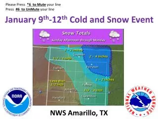
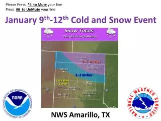
Please Press *6 to Muteyour line Press #6 to UnMute your line January 9th-12th Cold and Snow Event NWS Amarillo, TX
Changes from Yesterday • Winter Weather Advisory is in effect between 6 pm today and 6 pm Monday over the Oklahoma and North Central/Northeast Texas Panhandles for 1 to 5 inches of snow along with light freezing drizzle accumulations up to 0.10 inch. • Snow will not begin until after midnight tonight across the Oklahoma and North Texas Panhandle, and during the day on Monday across much of the rest of the Panhandles.
Snow Event • Snow will begin mainly after midnight tonight. Snow will spread over the entire area by Monday morning. • Heaviest snow expected late tonight and Monday across the northeastern Panhandles. • Southeasterly winds 10 to 20 mph with higher gusts tonight will become northerly late tonight into Monday and increase to 20 to 30 mph with higher gusts. • Blowing and drifting of the snow and reduced visibilities expected at times on Monday.
Temperature Summary • Arctic front blasts through the region late tonight into Monday morning. • Bitterly cold temperatures expected Monday through Wednesday, particularly on Tuesday. • Some places may remain below freezing for up to 90 hours. • Northerly winds will produce dangerously low wind chill values. WIND CHILLS ***Lowest wind chills Tuesday and Wednesday mornings***
Confidence • Storm Track – High • Precipitation Type • Snow – High (late tonight and Monday) • Freezing Drizzle – Low - Will temperatures be below freezing tonight into Monday morning if drizzle occurs? • Snow Timing – High (begins mainly late tonight over North Panhandles and ends Monday afternoon) • Strong Winds – High (Northerly winds 20 to 30 mph with higher gusts) • Blowing and drifting snow expected on Monday. • Snowfall amounts – Moderate • Due to location of heaviest band and moisture quality • Dangerously Cold Wind Chills – High • Especially Tuesday and Wednesday mornings
Impacts • Travel concerns are possible mainly across the northeast half of the Panhandles due to possible snow covered roads. • All Highways and Surface Streets • Visibility restrictions can be expected due to the falling and/or possible blowing and drifting of the snow. • Dangerously cold Wind Chills can be expected Monday through Wednesday mornings. • Especially Tuesday and Wednesday morning