Atmosphere
Atmosphere. Higher Geography: Physical Environments. Skin cancers. Acid rain. Global warming. Greenhouse gases. Atmosphere in the news. Hole in the ozone layer. CFC’s. Climate change. Introduction. Although considered a difficult topic, this is the most up-to-date of the basic units!.

Atmosphere
E N D
Presentation Transcript
Atmosphere Higher Geography: Physical Environments
Skin cancers Acid rain Global warming Greenhouse gases Atmosphere in the news Hole in the ozone layer CFC’s Climate change Introduction Although considered a difficult topic, this is the most up-to-date of the basic units!
What we will learn Atmosphere for Higher Geography is being able to say how energy is moved around the world: • in the air (air circulation) • and the sea (ocean circulation)
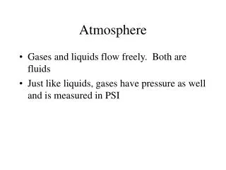
What is the atmosphere? The atmosphere is the gases that surround our planet. They are held in place by gravity. Atmosphere is made up of several gases. Without it there would be no life on Earth!
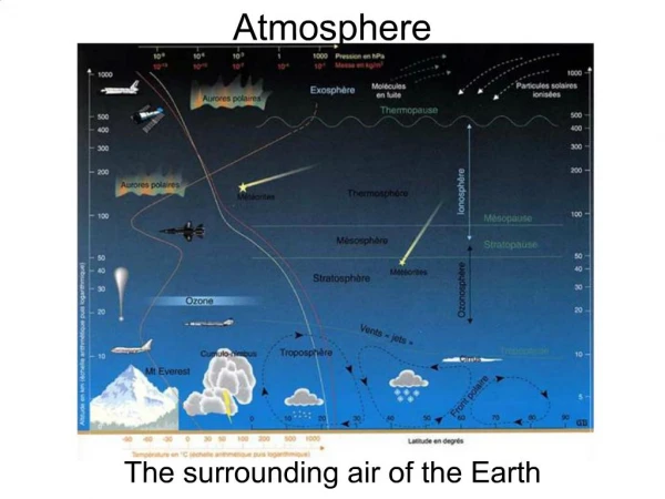
Structure of our Atmosphere The atmosphere is divided into four main layers, each with a characteristic mixture of gases and a range of temperatures. You will need to know the order these layers come in and their names. Note that between each layer is a junction called a ‘pause’.
Global Heat Budget The amount of energy the Earth gets from the sun and how it is used / absorbed or reflected. Insolation = Energy coming into our atmosphere (input) Radiation = Energy coming out of the atmosphere (output)
Activity Global heat budget bingo! You have 5 minutes to read your statement cards and number them according to where you think they go on the blank global heat budget. We will then see who got it right!
2 3 4 12 1 8 11 7 10 6 9 5
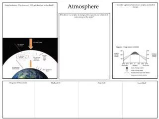
This would only apply in a perfect world…but we have an imbalance. Why do the poles get less energy? Why does the equator get more energy?
Extra Notes… In Polar regions, there is a greater amount of atmosphere to pass through, so more risk of it being deflected away. Because of the angle of the rays, there is more Polar land to share the heat than at the Tropics, so it averages cooler temperatures. Light coloured surfaces- like snow- reflect heat back into the atmosphere.Forests- like rainforests- are dark and absorb heat. Throughout the year, Polar areas get less time in the Sun than do Tropical areas due to the tilt of the Earth and the orbit around the Sun.
Starter On your show me boards, answer the following questions: • What is the name given to energy entering the Earth from the Sun. • Draw a diagram to show the 4 pauses of the atmosphere. • What percentage of solar insolation is reflected by the atmosphere? • Give two reasons why it gets colder as you move further from the equator.
Aims of the lesson • To learn about the formation of the 3 cells that exist in our atmosphere. • To learn about the pressure belts associated with each cell. • To learn about the wind patterns associated with these cells.
SOLAR ENERY Formation of the Hadley Cell Insolation in tropical areas causes warm air to rise and spread polewards, carrying heat energy. INSOLATION
NORTHERN HADLEY CELL. SOUTHERN HADLEY CELL. Air cools and begins to fall at about 30ºN and 30ºS of Equator. Cooled air returns to the Equator. SOLAR ENERGY Heat energy is therefore transferred from the Equator to sub-tropical latitudes.
Formation of the Polar Cell Intensely cold, dense air sinks at the poles, then blows as surface winds towards the Equator.
NORTHERN POLAR CELLS. SOUTHERN POLAR CELLS. At about 60ºN and 60 ºS, the cold polar air is warmed in contact with the earth’s surface. This warmed air rises and returns polewards, carrying heat energy. This circular motion is called the POLAR CELL.
Formation of the Ferrel Cell Unlike the Hadley and Polar Cells, the Ferrel Cell is not driven by differences in heat energy. The Ferrel Cell is caused by friction where air is in contact with the other two cells. (The Hadley Cell drags air down at about 30ºN and S. The Polar Cell causes an uplift at about 60ºN and S. )
THE THREE CELLS TOGETHER Polar Cell Ferrel Cell Hadley Cell Hadley Cell Ferrel Cell Polar Cell
Cells It is well worth making sure that you can see the rising and falling pattern of these cells. The next section uses this to work out wind directions on the surface of the earth.
ASSOCIATED PRESSURE BELTS Rising air at the equator causes the equatorial belt of low pressure Polar high pressure Mid latitude low pressure Descending air at about 30ºN and 30ºS causes the sub-tropical belt of high pressure Sub-tropical high pressure Equatorial low pressure Rising air at about 60ºN and 60ºS causes a mid-latitude belt of low pressure Sub-tropical high pressure Mid latitude low pressure Descending air at the poles causes the polar high pressure areas Polar high pressure
ASSOCIATED SURFACE WIND PATTERNS Winds always blow from high pressure to low pressure. They are deflected because of the Coriolis Force which come about because of the rotation of the earth. Polar high pressure Mid latitude low pressure Sub-tropical high pressure Equatorial low pressure Winds in Northern Hemisphere are deflected to the right. Sub-tropical high pressure Winds in the southern hemisphere are deflected to the left. Mid latitude low pressure These wind belts shift seasonally. (See next section) Polar high pressure
Explain how circulation cells in the atmosphere and the associated surface winds assist in the transfer of energy between areas of surplus and deficit. 8 Marks • This question is asking you to explain: • How cold air is transferred southwards towards the equator • How warm air is transferred northwards towards the poles • The winds that are created because of the moving air. • You should be mentioning: • Deficit at poles • Surplus at equator • Creating a balance
The Equator is an area of surplus energy, the poles are an area of deficit. • The Hadley cells form above the equator. • Warm air transfers the energy upwards into the atmosphere. It then moves northwards and southwards toward 30 degrees North and south of the equator. • The warm air cools and begins to drop at 30 N and 30 S, transferring warmer air northwards and southwards. • The cool air then travels back towards the equator. This creates the trade winds which assist in energy transfer.
Above the poles we find the polar cells. Cold air is pushed downwards towards the earth and travels down towards 60 N and S of the equator. • This movement creates the Easterlies winds which transfers cooler air to warmer latitudes. • As it travels over the land it warms and then begins to rise at 60 N and S allowing for warm air to be redirected back to the poles. • The Ferrel cells form between the Hadley and Polar cells and energy moves because of friction created. • These movements allow for warm air to redistribute the surplus energy from the equator to the poles.
This question is asking you about the reasons why there is an imbalance in the global heat budget. You should mention: • Impact of latitude • Thickness of the atmosphere • Distance from the sun • Albedo effect. Include diagrams!
Describe the pattern of ocean currents in the North Atlantic Ocean, and explain how they help maintain the global energy balance. 6 Marks • Answer could include: • Where cold currents travel from + named example • Where warm currents travel from + named example • How land masses deflect currents • What is happening to the surplus energy and deficit energy at equator/poles • How salt content effects currents • How winds / friction affect the direction of currents • The coriolis effect
There is an energy surplus at the equator and a deficit at the poles. • There are warm currents directed northwards fro the equator known as the gulf stream and north Atlantic current. • There are cold currents directed southwards from the poles one is called the east Greenland current. • Often ocean currents are deflected by land masses and circular shaped loops of water form called gyres. • This means that surplus energy often does not reach the poles. • In the N Atlantic ocean currents travel in a clockwise direction because of the coriolis force. • They also move in the direction of the prevailing winds due to friction.
Mark Scheme • Description and Explanation might include: currents follow loops or gyres – clockwise in the North Atlantic. In the Northern Hemisphere the clockwise loop or gyre is formed with warm water from the Gulf of Mexico (Gulf Stream/North Atlantic Drift) travelling northwards and colder water moving southwards eg the Canaries Current. currents from the Poles to the Equator are cold currents whilst those from the Equator to the Poles are warm currents. Cold water moves southwards from Polar latitudes – the Labrador Current. This movement of warm and cold water thus helps to maintain the energy balance. ocean currents are greatly influenced by the prevailing winds, with energy being transferred by friction to the ocean currents and then affected by the Coriolis effect, and the configuration of land masses which deflect the ocean currents. Due to differential heating, density differences occur in water masses, resulting in chilled polar water sinking, spreading towards the Equator and displacing upwards the less dense warmer water
Aims of the Lesson: • Revise air masses • Look at how the boundary of two conflicting air masses effect the climate in Africa. • Understand this conflict as the ITCZ (Inter Tropical Convergence Zone)
Air Masses An air mass is a large volume of air with uniform characteristics of temperature and humidity, acquired from its source region (where it comes from). The characteristics of the air mass are determined by the climate of the place where it originated. • Air masses which form over oceans are termed “MARITIME”. These will bring wet weather. • Air masses which form over land are called “CONTINENTAL” These will bring dry weather. • Air masses are also called POLAR, TROPICAL or ARCTIC depending on where they formed.
Air masses in Africa and the ITCZ • The main air masses influencing the climate of Africa are Tropical Continental and Tropical Maritime. • Their meeting place (where they converge) is known as the Inter Tropical Convergence Zone (ITCZ).
cT Where the air masses converge ITCZ mT Tropical Continental A warm, dry air mass given its origin over the tropical Sahara Desert. Brings warm, dry stable air. Extremely warm temperatures. No rainfall or cloud. Also brings a warm, dry Harmattan wind. Weather conditions are monotonous. AFRICA Tropical Maritime A warm, wet air mass given its origin over tropical oceans (the Atlantic). Brings moist, unstable air causing rainfall and thunderstorms. Temperatures can be hot and weather patterns vary.
Sahara Desert Sahel, semi desert South of Africa, Rainforest over equator, grasslands as you go south.
ITCZ is positioned at the Tropic of Cancer 23 ½ºN 0º 23½ºS ITCZ Tropic of Cancer Equator Tropic of Capricorn How does the ITCZ and its associated air masses influence the climate of Africa? The ITCZ shifts position throughout the year in relation to the apparent movement of the sun because of the way the earth sits on its axis. In July The sun is directly overhead the Tropic of Cancer due to the tilt of the earth. The ITCZ migrates northwards and is positioned over the Tropic of Cancer.
cT ITCZ positioned at Tropic of Cancer ITCZ Warm moist unstable Tropical Maritime Air dominates most of Africa. mT This means that Africa is dominated by the Tropical Maritime air mass, bringing with it warm,wet and generally unstable conditions. This explains why July is Africa’s wet season.
Tropic of Cancer Equator Tropic of Capricorn ITCZ 23 ½ºN 0º 23½ºS ITCZ is positioned at the Tropic of Capricorn In January The sun is directly overhead the Tropic of Capricorn due to the tilt of the earth. Therefore the ITCZ migrates south and is positioned over the Tropic of Capricorn.
Warm, dry stable Tropical Continental Air dominates most of Africa. cT ITCZ ITCZ positioned at Tropic of Capricorn mT This means that much of Africa is influenced by Tropical Continental air, bringing with it warm, dry stable conditions and the warm, drying Harmattan wind. This explains why most of Africa experiences its dry season at this time of year.
Some western and southern parts of Africa remain under the influence of Tropical Maritime air because the Tropical Continental air mass (above the ITCZ) is not strong enough to push against the Tropical Maritime air mass which is moving into the land from the sea. • In March and September the sun sits directly overhead the Equator, so at these times of year the ITCZ is positioned over the Equator.
Problems with the ITCZ in recent years In recent years the ITCZ has not migrated as far north as it should do in July. It has only shifted position to 14ºN of the Equator. This means that the Tropical Maritime (warm, wet) air does not reach the Sahel region of Africa. Instead, this part of Africa is dominated by Tropical Continental air, resulting in hot dry conditions and a summer drought. In Winter (January) the ITCZ migrates to its position at the Tropic of Capricorn so the Sahel region remains dominated by the warm, dry Tropical Continental Air. This means that for most of the year the Sahel region of Africa is influenced by extreme heat and dry conditions, causing drought, soil erosion, desertification and land degradation.
Task Time! Use your notes on the ITCZ to answer the following questions: • Write a definition for the ITCZ. • Why does the ITCZ appear to migrate to different positions throughout the year? • Where is the ITCZ positioned in a) July b) January c) September? • Explain why most of Africa experiences warm, wet weather in July. • Explain why most of Africa experiences its dry season in January. • Why do some parts of western and southern Africa always experience Tropical Maritime air? • What has happened to the movement of the ITCZ in recent years? • Describe the consequences of this movement on the Sahel region of Africa. • Have a go at ACTIVITY 6 on page 7 of the Higher Geography textbook
Example exam question (1) From Paper 1 2007: Study reference diagrams Q1A and Q1B. Identify air masses A and B, and describe their origin and nature. (6)