ABC’s to Oceanography
ABC’s to Oceanography. A tmosphere B uoyancy C urrents D ensity E pipelagic Zone F ood Chain G ulf Stream H ydrophones I nertia J ason-1 K not L ead Line M eteorology. N umerical Models O cean P hytoplankton Q uikSCAT R ain S ea Spray T ides U pwelling V ector Wind Stress

ABC’s to Oceanography
E N D
Presentation Transcript
Atmosphere Buoyancy Currents Density Epipelagic Zone Food Chain Gulf Stream Hydrophones Inertia Jason-1 Knot Lead Line Meteorology Numerical Models Ocean Phytoplankton QuikSCAT Rain Sea Spray Tides Upwelling Vector Wind Stress Waves Heat Flux Oceanography Zooplankton Index of Oceanography Terms
A thin blanket of air that protects Earth The atmosphere is crucial to life on Earth Without the atmosphere: Organisms would die within a few minutes There would be no lakes, oceans, sounds, clouds, or red sunsets Earth would experience extremely cold temperatures at night and extremely warm temperatures during the day Did you know? If Earth were the size of a beach ball, the atmosphere would be thinner than a piece of paper Fast Fact: 99% of the atmosphere is contained within 30 kilometers of Earth’s surface http://www.flickr.com/photos/blueforce4116/1398244602/ http://www.flickr.com/photos/blueforce4116/1398244814/in/set-72157602039248380/ A tmosphere Image from Microsoft Office Clip Art
Fog Stratocumulus Cumulus http://www.flickr.com/photos/kubina/152730867/ http://www.flickr.com/photos/momofone98/140363329/ http://www.flickr.com/photos/mre770/322389785/ • Extension of Atmosphere • The atmosphere and the ocean are closely linked • The entire atmosphere holds as much heat as the top 2.5 meters (8 feet) of the ocean • The entire atmosphere holds as much water as 2.5 centimeters (1 inch) of the ocean • Atmospheric Boundary Layer (ABL) - lowest part of the atmosphere • Wind strength and the heat flux between the air and ocean impact ABL thickness • Cloud patterns within the ABL • Cumulus & stratocumulus at the top of a humid ABL • Fog at the bottom of a stable ABL (little mixing)
Did you know? Human bodies cannot sink in the Dead Sea because the water is so dense http://www.flickr.com/photos/machielse/363855772/ B uoyancy • A force created by differences in density • When two substances with different densities are mixed in a container, buoyancy causes the: • Less dense substance to rise to the top • More dense substance to sink to the bottom • Where is buoyancy visible in real life? • Hot air balloons rise in the air because the warm air inside the balloon is less dense than the surrounding air • Syrup sinks to the bottom of a glass of water because syrup is more dense than water Image from Microsoft Office Clip Art Image from Microsoft Office Clip Art
Continuous, directed movement of large streams of ocean water Two major types of currents: Surface Currents Form when surface winds push the water in the direction of the wind Deep Ocean Currents Huge water masses move and mix in response to changes in water temperature and salinity Why are currents important? Currents influence the climate, ship routes, and the lives of plants and animals living on land and in oceans Fast Fact: Surface currents affect the top 10% of the ocean C urrents Fast Fact: The Gulf Stream is both a surface current and a deep ocean current http://science.hq.nasa.gov/oceans/physical/OSC.html
Expected path of water without Coriolis Effect Actual path of water with Coriolis Effect • Extension of Currents • Coriolis Effect - the earth’s rotation causes ocean currents to bend • Northern Hemisphere currents forced to the right • Southern Hemisphere currents forced to the left • Coriolis force is strongest at the Poles and weakest at the equator • The bending angle of currents increases with ocean depth • A deep ocean current may flow in a direction different than the surface current Image from Microsoft Office Clip Art 20
A measure of how heavy something is in relation to its size (mass per unit volume) Temperature and salinity affect the density of ocean water What is salinity? A measure of the amount of salt dissolved in water Fast Fact: All the land on earth would be covered with 5 feet of salt, if the ocean’s salt content were dried D ensity Image from Microsoft Office Clip Art Image from Microsoft Office Clip Art • Graph shows density of ocean water based on salinity and temperature • Observations from graph: • An increase in temperature results in a • decrease in density • An increase in salinity results in an • increase in density 16
Extension of Density • Ocean density changes throughout • Low density water can be found near the surface • High density water can be found deep in the ocean • Pycnocline – an ocean layer where water density increases rapidly with depth • Changes in the density of surface water: • If the density of the surface water decreases • Its position will remain the same • If the surface water becomes more dense • than the water below • It will sink to a level where there is • water with the same density 18 18
Epipelagic Zone Mesopelagic Zone Fast Fact: Light penetrates hundreds of feet in the Caribbean, but only a few inches in the Hudson river E pipelagic Zone • Top layer of the ocean where sunlight is present • Plants take in the sunlight to complete photosynthesis • The epipelagic zone is the only zone where plants are found • What can be found below the epipelagic zone? • The mesopelagic zone, or twilight zone • The dim light found in this zone does not provide enough energy for plants to perform photosynthesis • In the 3 zones that exist beyond this zone there is zero sunlight 22
Fast Fact: 99% of earth’s living space is contained by the oceans F ood Chain • A sequence of marine organisms that pass nutrients to one another • Sun - main source of energy for marine food chains • Producers take in the Sun’s energy to make their food • Phytoplankton – major producers in the ocean • Consumers eat other organisms since they cannot produce their own food • Does pollution harm the food chain? • Yes • If phytoplankton absorb marine pollutants, the pollutants eventually accumulate to lethal levels in larger animals • What is a food web? • Several intertwined food chains resultant of organisms belonging to more than one food chain 20
A strong, warm water ocean current General flow of the Gulf Stream: The current begins in the western Caribbean Sea, passes through the Gulf of Mexico and the Straits of Florida, and then flows along the North American coast to northern European waters The exact path the current takes changes daily Example impact of the Gulf Stream: The current is about 80°F near the Gulf of Mexico The Gulf Stream releases heat into the atmosphere as it cools along its journey Added heat in the atmosphere significantly warms Europe Did you know? Benjamin Franklin named the Gulf Stream The 1786 version of the Franklin-Folger map of the Gulf Stream G ulf Stream 10 Modern Map of the Gulf Stream 16
Fast Fact: The rate of flow in the Gulf Stream at the Straits of Florida is 300 times the rate of flow in the Amazon river • Extension of Gulf Stream • The Gulf Stream flows at a rate of 4 miles per hour (6.5 kilometers per hour) • The strong current can be felt as deep as 1500 feet from the surface • Characteristics of the boundary between the Gulf Stream and the surrounding water: • The temperature is usually 11°F to 18°F (6°C to 10°C) • warmer than water surrounding the current • The water within the Gulf Stream is • warm and clear blue due to its lack • of nutrients • The water surrounding the Gulf Stream is • cloudy green due to the large • quantity of phytoplankton 17 False-Color Image of Temperature Data for Gulf Stream
H ydrophones • Underwater microphones that record underwater sound • Sound in the ocean is produced mainly by: • Bubbles created from breaking waves and falling rain • The engine and propellers of ships • Marine mammals like whales and dolphins • Why do scientists record the sound of rain falling on the water? • To measure and understand global rainfall patterns • Rain is a very important part of climate • The measurements help meteorologists, oceanographers, and scientists in their study of the climate Image from Microsoft Office Clip Art Image from Brüel & Kjær Sound & Vibration Measurement A/S http://www.bksv.com/pdf/Bp0317.pdf
The property of an object to remain at a constant velocity (speed) unless acted on by an outside force The ocean has a high temperature and momentum inertia in comparison to the atmosphere Example of oceanic vs. atmospheric inertia: Circulation in the ocean occurs at a slow rate Changes occur over months, years, decades, and centuries Atmospheric weather systems form and break apart within a single day Changes occur over seconds, minutes, hours, and days Fast Fact: Inertia is Sir Isaac Newton’s 1st Law of Motion I nertia Image from Microsoft Office Clip Art Image from Microsoft Office Clip Art Image from Microsoft Office Clip Art
Why do oceanographers use altimeters? Detect and monitor ocean currents Tide monitoring modeling Oceanographers need to be able to study all of the worlds’ oceans to understand their impact on our weather and climate Jason-1 is an Earth-orbiting satellite used for ocean surveillance Launched in December 2001 Radar altimeters on Jason-1 measure sea level: Microwave signals are sent by the altimeter to the ocean’s surface The length of time it takes the signal to travel down to the surface and back is recorded Scientists use this information and the satellite’s location to determine sea level J ason-1 http://science.hq.nasa.gov/oceans/physical/OST.html
Did you know? If Jason-1 was flying at 35,000 feet(like a jetliner), it could measure the thickness of a dime http://www.flickr.com/photos/umpqua/96624719/ • Extension of Jason-1 • In order to mathematically determine the distance from the satellite to the ocean surface: • Divide the total time by two and multiply by the speed of light (c ≈ 3 x 10⁸) • Water vapor in the air can cause Jason-1 to overestimate the distance from the satellite to the ocean’s surface by as much as 10 centimeters • Jason-1 listens to the radio waves produced by the clouds and the ocean, to • determine the amount of water vapor in the air and correct for the error • Jason-1 is able to complete its entire process and transmit the data back to earth within 3 hours http://lennthompson.typepad.com/lenndevours/miscellaneous_sips/index.html Image from Microsoft Office Clip Art
How did early sailors use a knot to measure the speed of a ship? Knots were tied at regular intervals along a rope and a log was attached to the end The rope was thrown overboard and the log floated along behind the moving ship A sailor counted the number of knots that passed through his hands during a specified amount of time The more knots that passed through the sailors hands, the faster the ship was moving The term knot continues to be used today to measure a ship’s speed A knot is a nautical mile per hour A nautical mile equals 6,076 feet or 1,823 meters 1 knot is equal to 1.15 miles per hour (mph) or 1.85 kilometers per hour (kph) Fast Fact: Most cruise ships travel at a maximum speed of 22 knots or 25.3 mph K not http://www.flickr.com/photos/tcd123/743633948/ http://www.flickr.com/photos/lyng883/329639190/
L ead Line Lead Line • A long piece of rope that had a lead weight tied at one end and markings in six foot intervals • The weight was thrown into the ocean • Measurements were taken by noting how much line went into the ocean until the lead reached the bottom http://celebrating200years.noaa.gov/transformations/hydrography/side.html • Lead lines were used by early sailors to determine: • Ocean depth at certain points along a journey • What is currently used to measure ocean depth? • Echo sounders provide oceanographers with a • graphical view of the sea floor Echo Sounder http://en.wikipedia.org/wiki/Echo_sounding
Fast Fact: The speed of sound in water is 4 times faster than the speed of sound in air • Extension of Lead Line • How do echo sounders measure sea level? • A pulse of sound energy is sent toward the bottom • of the ocean • Sound disturbs water as it travels through it, • creating sound waves • The amount of time it takes the pulse to travel to the bottom and back up to the surface is recorded and the depth of the water is then calculated • Sound waves are the most efficient signal in sensing the ocean below a depth of a few 10’s of meters • The average speed of sound in water is 1500 meters per second • Applies to ocean water free of air bubbles • Speed of sound in water is dependent on: • Depth of ocean water • Temperature • Salinity 16 Graph of the Speed of Sound (C) at various depths of the ocean
The physics, chemistry, and unique processes of Earth’s atmosphere are explored in great detail by meteorologists Meteorologists try to completely understand the atmosphere, so they can predict how it is going to behave Meteorology is the study of the atmosphere and the interaction between the atmosphere and the land, ocean, and life M eteorology Image from Microsoft Office Clip Art Image from Microsoft Office Clip Art Image from Microsoft Office Clip Art Image from Microsoft Office Clip Art Image from Microsoft Office Clip Art
Mathematical calculations that provide oceanographers with detailed views of circulation in the oceans Two main types of numerical models: Mechanistic models – simplified models that examine the mathematics behind physical processes Simulation models – complex models that can be used to calculate the realistic flow in the ocean What are some of the advantages and disadvantages of using numerical models? Advantage: The models can be used to simulate realistic flow and predict future flow in the ocean Disadvantage: The models cannot give completely accurate descriptions of the flow in the ocean N umerical Models Image from Microsoft Office Clip Art
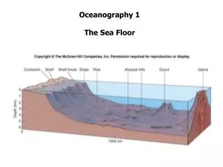
Did you know? The pressure at the deepest point in the ocean is equivalent to 1 person trying to hold 50 jumbo jets Fast Fact: The average depth of the ocean is 3.7 km (about 2 miles) Fast Fact: 71% of Earth’s surface is covered by oceans O cean • A large body of salt water • Millions of years ago Earth’s surface was very hot and all the water boiled away • Volcanoes released large amounts of steam into the atmosphere • As Earth cooled, the steam changed to water vapor, and condensed to raindrops • Rain fell thousands of years filling all the cracks on Earth with ocean water http://www.ngdc.noaa.gov/ • What impact does air-sea interaction have on Earth? • The ocean constantly interacts with the atmosphere, exchanging heat, moisture, and carbon dioxide (CO2) • The air-sea interaction drives our weather patterns and influences the slowly occurring but dramatic changes in our climate
Fast Fact: On a favorable day, phytoplankton concentration may increase by as much as 300% P hytoplankton • Microscopic, single-celled marine plants that need water, CO2, sunlight, and chemical nutrients to grow • Phytoplankton use a pigment called chlorophyll to capture sunlight during photosynthesis • They decrease the amount of sunlight that reaches deeper water • Confines oceanic heating to a small layer • Why are phytoplankton important? • Approximately half of the oxygen we breathe is produced by phytoplankton • They take in CO2 from the atmosphere at the same rate as land plants • All marine life is dependent upon the quantity of phytoplankton available http://www.flickr.com/photos/dodeckahedron/132430686/
Fast Fact: On a favorable day, 20,000 specimens of phytoplankton may be contained in 1 ft3 of ocean water • Extension of Phytoplankton • Currents can usually be traced by their supply of phytoplankton • Scientists use satellites to remotely observe chlorophyll, which is contained in the phytoplankton • The images tell them: • How much phytoplankton is present in the ocean • Where they are located • How much work they are performing • How their populations are changing • On Earth, humans can observe the phytoplankton present in lakes and oceans • Chlorophyll absorbs blue and red light • and reflects green light • A water source that appears green in color most likely contains some phytoplankton Image from Microsoft Office Clip Art
A satellite NASA uses to create an image of the surface winds on Earth The QuikSCAT satellite carries a SeaWinds scatterometer A scatterometer is a microwave radar that can measure near-surface wind speed and direction over the ocean under any weather conditions Why are scatterometers useful? They are giving meteorologists: More accurate measurements of the winds associated with storms Advanced warning of high waves and flooding Q uikSCAT http://science.hq.nasa.gov/
Did you know? Falling drops of rain are not tear-shaped R ain • Precipitation that falls from clouds toward Earth’s surface • Rain is an important part of the climate • The latent heat released into the atmosphere upon the formation of raindrops is a significant form of energy that drives circulation in the atmosphere • Why do meteorologists, oceanographers, and climate scientists find it important to measure rainfall patterns? • Scientists suspect that after rainfall the layers of fresh water at the surface of the ocean affect circulation in the ocean • Rainfall appears to calm the seas • Scientists question impact of rainfall on ocean damping http://www.flickr.com/photos/viewthis/521909936/
Diameter • Extension of Rain • Drizzle – water droplets with a diameter less than 0.5 millimeters (mm) • Rain – water droplets with a diameter greater than or equal to 0.5 mm • The diameter of a raindrop that reaches Earth’s surface is usually no greater than 6 mm • The shape of a raindrop is dependent on its size: • Almost spherical – raindrops less than 2 mm in diameter • Surface tension squeezes the drop into a sphere because • spheres have the smallest surface area for their total volume • Flattened bottom, rounded top – raindrops with diameters bigger than 2 mm • Larger air pressure on the drop as it falls, flattens the bottom, while lower • air pressure on the sides of the drop allows the sides to expand 1
There are two types: Film or jet droplets – bubbles in the ocean rise to the surface and burst, releasing water droplets into the air Spume droplets – the wind is strong enough to tear off water particles from the tops of waves How does sea spray impact the earth? Once sea spray becomes airborne, the particles scatter radiation and transfer heat, momentum, and moisture to and from the atmosphere If the sea spray evaporates entirely, sea salt particles are left in the air The particles act as nuclei for clouds and fog to form They impact Earth’s annual heat budget Sea Spray Fast Fact: Sea salt particles make up 90% of the marine aerosols in the Atmospheric Boundary Layer S ea Spray http://www.flickr.com/photos/49827759@N00/98131368/
Radius 1 millimeter OR 1000 micrometers • Extension of Sea Spray • 1000 micrometers = 1 millimeter • Radius of film or jet droplets: ranges from approximately 1 to 10 micrometers • Radius of spume droplets: ranges from approximately 10 to 1000 micrometers • The radius of a circle: http://science.nhmccd.edu/biol/dropdrag/superimposed.htm
Low Tide High Tide High Tide Gravitational Pull Low Tide Did you know? Tides do not actually “rise”, rather Earth rotates into tides T ides • The regular rise and fall of the ocean waters • Caused by the gravitational pull of the Moon and Sun, and the rotation of Earth • The rising of Earth’s surface is called high tide, or flood tide • The centrifugal force away from the moon leaves the water on the side opposite to the Moon to form another high tide • Low tides, or ebb tides, are the portions of the tidal cycle between high tides Image from Microsoft Office Clip Art • What impacts the time tides occur each day? • The combination of Earth’s rotation and the Moon’s orbit • If the Moon did not rotate around Earth, the tides would occur at the same time every day
Extension of Tides • The rise and fall of the tides is periodic • Periodic – occurring in regular cycles • There are three types of tides: • Semidiurnal Tides: • Produce two high tides and two low • tides during a 24 hour period (1 day) • Diurnal Tides: • Produce one high tide and one low • tide during a 24 hour period (1 day) • Mixed Tides: • Produce two high tides and two low • tides during a 24 hour period (1 day) • There are great differences between the • heights of the high tides and the low tides • To the right are tide curves for the three common types of tides • Curves show tidal patterns during a 48 hour • period (2 days) at various locations around • North America 4 4 4
Coastal Upwelling and Downwelling in the Northern Hemisphere Wind out of the North Wind out of the South Downwelling Upwelling U pwelling • Vertical movement of water from the ocean floor up to the surface • Coastal Upwelling - occurs when winds blow with the shore on the left • Surface water is pushed away from the beach and deep, nutrient-rich, cold ocean water rises in its place • Coastal Downwelling - when winds blow with the shore on the right • Surface water is pushed toward the beach, forced downward, and then out to sea • Northern Hemisphere: ocean water moves 90° to right of wind • Southern Hemisphere: ocean water moves 90° to left of wind
V ector Wind Stress • The horizontal force per area of wind on the ocean surface • Vector wind stress impacts: • Generation of waves • Movement of surface currents • How does vector wind stress impact air-sea interaction? • Through wind stress the atmosphere is able to transfer momentum to the ocean http://www.pfeg.noaa.gov/products/las/sample_gifs.html
As wind passes over the water, friction between the air and the water causes the water to ripple Characteristics of waves: Period – time for two crests or troughs to pass a point Wave frequency – number of waves that pass a point in one second What determines the size of waves? How fast the wind is blowing How far the wind blows How long the wind blows Image from Microsoft Office Clip Art Did you know? A wave does not move water, only energy moves forward W aves 20
Extension of Waves • As a wave passes, water particles lift up, move forward with the wave’s crest, and then sink down and move backward with the wave’s trough • When water particles in the trough hit the sand, friction causes them to slow down, but the water particles in the crest do not slow down • When the water in the crest gets too far ahead for the trough to be able to support it, a breaker forms, which is a wave where the crest crashes on top of the trough 20 Image from Microsoft Office Clip Art Image from Microsoft Office Clip Art Image from Microsoft Office Clip Art
Heat Flu X Image from Microsoft Office Clip Art • The passing of heat through or across a surface • The heat flux within shallow layers is much greater than within deep layers of the ocean The mean annual radiation and heat balance of Earth • Example of the importance of heat flux to Earth: • Earth must maintain an • annual balance between the • amount of heat absorbed by • its surface and released • back into the atmosphere 16 W m-2 (watts per square meter) is the unit used to represent the power per square area that comes from the sun
Y Oceanograph • Scientific study and exploration of the oceans • Dependent on physics, chemistry, biology, geology, and meteorology • Covers a wide range of topics: • currents, waves, tides, marine organisms, ocean floor, etc. • Oceanographers must be able to apply knowledge from various branches of study to truly understand and be able to explain the behavior of the ocean environment Image from Microsoft Office Clip Art • Is there more than one type of oceanography? • Yes • Biological oceanography (Marine biology) – study of marine plants and animals • Chemical oceanography – study of the chemistry of the ocean and ocean floor • Geological oceanography – study of the ocean floor • Physical oceanography – study of ocean processes and air-sea interactions Image from Microsoft Office Clip Art
Copepod http://www.flickr.com/photos/kervinchong/498036786/ Zooplankton http://www.flickr.com/photos/paulgalipeau/834103339/ Z ooplankton • Micro- or macroscopic animals that drift in the ocean • Zooplankton can live at any ocean depth • In comparison to any other animal, zooplankton have the greatest quantity spread over the largest area • Typically found near large quantities of phytoplankton • Concentrated in areas of upwelling • Why are zooplankton important? • They are a stable source of food • for many larger animals
References 1. Ahrens, C. D. (2005). Essentials of Meteorology: An Invitation to the Atmosphere (4th ed.). California: Thomson. 2. Feldman, J. C. Ocean Planet: Oceanographic Facts. Smithsonian Institution. Retrieved July 13, 2007, fromhttp://seawifs.gsfc.nasa.gov/OCEAN_PLANET/HTML/education_ oceanographic_facts.html 3. Greely, T. (1998, Fall). Lesson 1: Why are the Oceans Important? Project Oceanography. Retrieved July 13, 2007, from http://www.marine.usf.edu/pjocean/packets/ 4. Groves, D. (1989). The Oceans: A Book of Questions and Answers. New York: John Wiley & Sons, Inc. 5. Herring, D. Ocean & Climate: Physical Coupling with the Atmosphere. NASA. Retrieved June 7, 2007, from http://earthobservatory.nasa.gov/Library/OceanClimate/ocean- atmos_phys.html. 6. Hutchinson, S. & Hawkins, L. E. (2005). Oceans: A Visual Guide. New York: Firefly Books. 7. Kawasaki, K. (2006, September 5). Mapping the Oceans. NASA. Retrieved June 7, 2007, from http://sealevel.jpl.nasa.gov/education/jason-game/game-mapping-oceans.pdf 8. Kawasaki, K. (2006, September 5). See How Winds Drive Ocean Currents. NASA. Retrieved June 7, 2007, from http://sealevel.jpl.nasa.gov/education/jason- game/game-activity2.pdf 9. Looking at the Sea: Physical Features of the Ocean. (1998). Science Learning Network. Retrieved June 7, 2007, from http://www.mos.org/oceans/planet/features.html 10. Looking at the Sea: The Water Cycle. (1998). Science Learning Network. Retrieved June 7, 2007, from http://www.mos.org/oceans/planet/cycle.html
Extension of References 11. Mueller, J. A. & Veron, F. (2006). A LaGrangian Turbulent Transport Model of Evolving Sea-Spray Droplets over the Ocean. AMS: 14th Conference on Interaction of the Sea and Atmosphere. (Vol. P4.3) 12. Niller, P. (1993). Gulf Stream. In The World Book Encyclopedia (Vol. 8, pp. 462-463). Chicago: World Book, Inc. 13. Nystuen, J. (2000, June 14). Listening to Raindrops: Using Underwater Microphones to Measure Ocean Rainfall. NASA. Retrieved June 7, 2007, from http://earthobservatory.nasa.gov/Study/Rain/ 14. Ocean in Motion. (2004, April 7). Office of Naval Research. Retrieved June 8, 2007, from http://www.onr.navy.mil/focus/ocean/default.htm 15. Program 1: The Who? What? Where? How? And Why’s? of Plankton. (1997, Fall). Project Oceanography. Retrieved July 13, 2007, from http://www.marine.usf.edu/ pjocean/packets/ 16. Sample, S. (2005, June 21). Climate Variability. NASA. Retrieved June 8, 2007, from http://science.hq.nasa.gov/oceans/system/climate.html 17. Sample, S. (2005, June 21). Sea Surface Temperature. NASA. Retrieved June 26, 2007, from http://science.hq.nasa.gov/oceans/physical/SST.html 18. Sample, S. (2005, June 21). The Water Cycle. NASA. Retrieved June 8, 2007, from http://science.hq.nasa.gov/oceans/system/water.html 19. Stewart, R. H. (2005). An Introduction to Physical Oceanography. Texas: Texas A & M University. 20. Stull, R.B. (1988). An Introduction to Boundary Layer Meteorology. In Atmospheric Sciences Library (Vol. 13). Massachusetts: Kluwer Academic Publishers.
Extension of References 21. Tarbuck, E. J. & Lutgens, F. K. (2003). Earth Science (10th ed.). New Jersey: Pearson Education. 22. The Living Sea. (1998). Science Learning Network. Retrieved June 7, 2007, from http://www.mos.org/oceans/life/index.html 23. VanCleave, J. (1996). Oceans for Every Kid: Easy Activities that Make Learning Science Fun. New York: John Wiley & Sons, Inc. 24. Water on the Move: Current Events. (1998). Science Learning Network. Retrieved June 7, 2007, from http://www.mos.org/oceans/motion/currents.html 25. Water on the Move: Wind and Waves. (1998). Science Learning Network. Retrieved June 7, 2007, from http://www.mos.org/oceans/motion/wind.html LEEANNE HAZZARDis a senior at Elizabethtown College, where she is working on her Secondary Mathematics certification. Leeanne created this ABC’s to Oceanography booklet as part of the Oceanography Outreach Project she designed during a REU Summer Internship. Created by Leeanne Hazzard & Fabrice Veron, 2007 Air-Sea Interaction Laboratory College of Marine and Earth Studies University of Delaware