Download
1 / 1
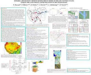
10 likes | 230 Vues
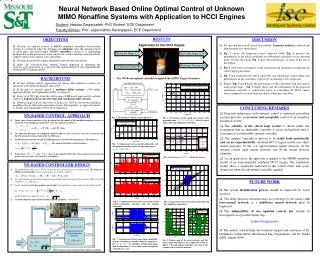
TOWARDS A MECHANISTIC, REMOTE-SENSING DRIVEN MODEL OF ORGANIC MATTER CYCLING LINKING THE LAND SURFACE AND RIVER SYSTEM IN THE AMAZON BASIN. Amazon River Basin Biogeochemical Model. River Routing and Sediment Transport Network. Land Surface Processes (Grid). COGM Organic Carbon Module.

E N D
TOWARDS A MECHANISTIC, REMOTE-SENSING DRIVEN MODEL OF ORGANIC MATTER CYCLING LINKING THE LAND SURFACE AND RIVER SYSTEM IN THE AMAZON BASIN Amazon River Basin Biogeochemical Model River Routing and Sediment Transport Network Land Surface Processes (Grid) COGM Organic Carbon Module COGM Nitrogen Module E. MayorgaUW, V. BallesterCENA, J.E. RicheyUW , A. KruscheCENA, A. AufdenkampeUW , R. VictoriaCENA • Objectives • We present our current developments towards an integrated modeling framework aimed at quantitatively describing the dynamics of organic matter (OM) cycling in mesoscale to large rivers by mechanistically tracking the evolution of OM from the land, through the river corridor, to the river. The biogeochemical model is tightly coupled to spatially distributed models of water and sediment cycling and transport. Development and testing center on the Amazon basin, building on two decades of detailed biogeochemical studies in a large variety of riverine environments, and more recent work using long, continuous time series of basin-wide satellite images to detect land surface dynamics and force hydrological and biosphere models. Emphasis is placed on the larger temporal and spatial scales (monthly - decadal, mesoscale - continental), and on the more refractory OM components. We are interested in developing model frameworks applicable to both terrestrial and aquatic environments, and with the following short- and long-term goals: • Evaluate our understanding of how biogeochemical and physical processes integrate in a river basin. • Quantitatively constrain the importance of geochemical and physical processes and predict compositions and fluxes of bioactive elements at inaccessible locations and for different land-use and climate change scenarios. • Improve our ability to infer upstream landscape environments and sequence of processes from observed biogeochemical signatures within a parcel of water. B A Figure 4:Sample compositional trends for the Beni-Madeira Andean transect in Bolivia-Brazil.A. Downstream increase in % of High Molecular-Weight DOM (descending from the Andes). B. Biochemical degradation parameters. Squares indicate the entire range for each fraction from Amazon mainstem and tributary mouths. %(BALA+GABA) is the sum of mole % of non-protein amino acids b-alanine and g-amino butyric acid. (Ad/Al)v is the acid to aldehyde ratio of vanillyl lignin phenols. F, C and D stand for FPOM, CPOM and UDOM, respectively. Figure 5:Amazon River Basin Biogeochemical Model. Preliminary, working concepts. The carbon and nitrogen process models (COGM: CAMREX Organic Geochemistry Model) are shown below. Above are schematic examples of the spatial integration of the process models into different physical and flow environments. Figure 1:Amazon basin and river system, showing the drainage areas of major tributaries, national boundaries, CAMREX sampling locations, and the Beni-Madeira transect (arrow). Background and Motivation The biogeochemical imprint of rivers results from a complex mixture of materials originating in heterogeneous regions and transformed during fluvial transit. Many approaches have been used to explain river observations in terms of key processes and dominant regions of influence: careful mass balance and compositional studies in small catchments, considering major sources and transformations; statistical identification of basin-aggregated controls; analysis of the elemental, molecular, and isotopic composition of riverine OM; and models of particular environments or flowpaths. While each method has unique strengths, they can suffer from difficulties in extrapolating to larger rivers draining heterogeneous environments, lack of mechanistic underpinning and validation, or an inability to make quantitative statements about the relative importance of different processes. OM models developed for terrestrial systems pay little attention to exports to rivers, and the common paradigm used for soil OM compartments is based on turnover rates. Our ongoing research has demonstrated the importance of physical and geochemical properties in controlling the preservation and fractionation of OM. • Framework Elements • 1. Gridded (raster) data model • To match remote sensing data and facilitate aggregation and coding. • 2. Spatially distributed datasets • soil properties, land cover, topography, river network • 3. Remote sensing time series, basin-wide • AVHRR 5-km dataset, 1981-1998 time series, daily raw band radiances, • used to derive monthly climate-biophysical forcing variables (Fig. 2). • 4. “Vertical” land-surface models (Fig. 3) • Hydrology -- incorporate common set of key processes (evapotranspiration, soil moisture, runoff); currently using VIC-nL model. • Carbon cycling -- primary production, litterfall, soil OM, respiration; currently using CASA model. Most models are based on kinetic SOM pools, are not physically verifiable and not geochemically explicit • 5. Sub-scale (sub-pixel) stratification of cells into land elements. • 6. “Horizontal” transfer models • Lateral transfer: “upland” hillslope riparian stream • River routing (water, materials) • Floodplain exchanges: river floodplain hillslope • The river system will be subdivided into 3 scales: sub-pixel streams receiving direct input from the land, medium-scale streams handled in a generalized fashion, and larger-scale rivers treated explicitly (Fig. 6). • 7. Synthesis of CAMREX and related work specifying key controls and • mechanisms impacting the preservation, degradation, and resulting • composition of OM. • 8. New OM cycling model, (“COGM”) incorporating the above synthesis into a • quantitative framework (Figs. 4 and 5), and emphasizing measurable OM • compartments. Basic model construct applicable in both terrestrial and • aquatic environments. • 9. Comparison of COGM with CASA for the land surface. Evaluation • of system behavior, controls. • 10. Coupling of COGM with lateral transfers on land and rivers (Fig. 5). • Comparison of model results to CAMREX river observations. • 11. Implementation at two scales: whole basin, using 5-km AVHRR data. And • mesoscale Ji-Parana basin, using 1-km AVHRR data (Fig. 7). • 12. Validation of both land surface and river models, with a variety of methods. • 13. Analysis of ENSO and other interannual variability, and long-term change. • Elements Implemented • Spatial datasets, and climate-biophysical forcing variables derived from remote sensing time series (1981 - 1990). 1990 - 1998 raw data is currently being processed. • Consistent river network dataset. • Land-surface water and carbon models. • Simple river routing scheme (water and conservative materials). • CAMREX organic geochemical analysis of river transects (will be completed soon). • Initial work in sampling mesoscale basins, with an emphasis on the Ji-Parana. • Initial conceptualization of OM model, synthesizing our understanding. Figure 6:Amazon river system showing Strahler stream orders, where 1st order rivers represent those draining an area of 3000 km2; this is the river system that will be modeled explicitly. • Next Steps • Characterization of dominant patterns of seasonal and interannual variability throughout the basin. • Completion of OM model concepts, making them quantitative and implementing them into code. • Design of sub-scale stratification of land cells, emphasizing riverine corridors and lateral transfers. • Imlementation of models for Ji-Parana mesoscale basin, using 1-km AVHRR data and shorter time steps. • Design of validation schemes. a. Figure 2:1981-1990 mean monthly FPAR (absorbed fraction of photosynthetically active radiation), derived from AVHRR 5-km remote sensing data. High values (red) represent active vegetation. b. Figure 3:Schematics of vertical models. Left, CASA terrestrial biosphere model. Right, VIC-nL hydrology model. CASA Carbon Cycling Model c. VIC-nL Hydrology Model Acknowledgments This work is funded by grants from NASA (LBA-ECOLOGY, EOS, and Earth System Science Fellowships), the US NSF, and FAPESP. Figure 7:Amazon basin and Ji-Parana mesoscale basin. a. Amazon basin with national boundaries, topography, large rivers, and Ji-Parana basin b. Ji-Parana basin with sampled sites (note that elevation has been rescaled). c. Landsat TM samples.