Download
1 / 48
480 likes | 501 Vues
Learn about earthquakes, fault types, seismic waves, and measuring scales. Understand how plate movements cause quakes and the science behind locating epicenters. Explore the Richter Scale, seismographs, and Mercalli Scale to gauge earthquake impact. Discover the Moment Magnitude Scale's precision in measuring quake intensity. Gain insights into tsunami effects and earthquake simulations. Enhance your knowledge of earthquake causes and damages through interactive resources.

E N D
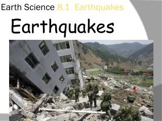
Earthquakes!! Be sure to fill in your notes sheet as you go through the power point!
Plate Boundary Review • Click on the link below to try some plate boundary movement simulations. • The link will take you to a website. Read the passage and then click on the Plate Tectonics Activity link on the website. • Click Here to go to the website. www.pbs.org/wgbh/aso/tryit/tectonics/
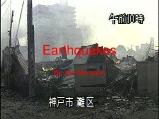
Earthquake of 1989 Occurred along the San Andreas Fault in CA Registered approximately 7.5 on the Richter Scale
Which type of boundary (convergent, divergent, or transform) and fault (strike-slip, normal, or reverse) caused this quake?
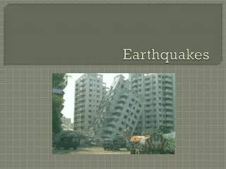
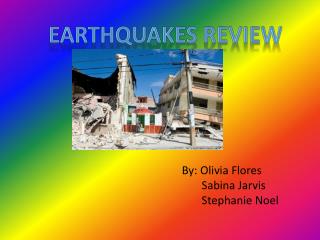
Earthquake photos • Look over the pictures on the following slides. • Be sure to notice the amount and type of damage caused by this earthquake.
THINK, PAIR, SHARE! • Using your knowledge of Plate Tectonics, how to Earthquakes cause all this damage? • Give three reasons • Trade with some one at your table and be ready to share!
Where do Earthquakes Start? • The starting point of an earthquake below ground is called a focus, or hypocenter. • The area directly above the hypocenter on land is called the epicenter. • Earthquakes are strongest at the epicenter and become gradually weaker farther away!
Locating the Epicenter Geologists use seismic waves to locate an earthquake’s epicenter.
The area where the 3 circles (from the 3 cities reporting a quake) meet isn’t perfect. They do not completely overlap each other at the exact location of the epicenter. The space of overlap is the TRIANGLE OF UNCERTAINTY. The earthquake started in this area! Triangle Of Uncertainty
- Earthquakes and Seismic Waves Types of Seismic Waves • Seismic waves carry energy from an earthquake away from the focus, through Earth’s interior, and across the surface.
- Earthquakes and Seismic Waves Types of Seismic Waves • P waves are seismic waves that compress and expand the ground like an accordion. S waves are seismic waves that vibrate from side to side as well as up and down.
Types of Seismic Waves Surface waves move more slowly than P waves and S waves, but they produce the most severe ground movements.
Is this a demonstration of p or s waves? Is this a demonstration of p or s waves?
Main Idea Detail Detail Detail Identifying Main Ideas Seismic waves carry the energy of an earthquake S waves vibrate from side to side as well as up and down. S-waves move at about ½ the speed of P waves! Surface waves produce the most severe ground movements & damage even though they move the slowest!. P waves compress and expand the ground. P waves move the fastest!
How are Earthquakes Measured? • Earthquakes are measured based on three different scales. • The first measures the actual size or magnitude of the quake. • The second measures the effects or damage of the quake. • The third measures the total energy of the quake.
How is the Size of Earthquakes Measured? • A seismograph is the the tool used to measure the strength of an earthquakes • The seismograph prints out a seismogram that scientists read to determine the strength of the quake. • The data from the seismogram is translated into a 1-10 rating on the Richter Scale. Each step in the scale represents a tenfold increase in the size of the quake!
What is a Seismograph • The Modern Seismograph • Seismic waves cause the seismograph’s drum to vibrate. But the suspended weight with the pen attached moves very little. Therefore, the pen stays in place and records the drum’s vibrations.
Sequencing How a Seismograph Works Incoming seismic waves Vibrate the rotating drum The suspended pen remains motionless and records the drum’s vibration.
How are the Effects Measured? • The Mercalli Scale measures the earthquake’s effects on a scale of 1-12 (in Roman Numerals). This is determined by scientists surveying the damage and then rating it on the scale. This scale is VERY subjective! • I: only detected by seismographs. • VI: felt by all, but very little damage • XII: causes total destruction.
Measuring Earthquakes The Mercalli scale was developed to rate earthquakes according to the amount of damage at a given place.
Moment Magnitude Scale • Preferred by scientists and seismologists to the Richter scale because moment magnitude is more precise. • not based on instrumental recordings of a quake, but is based on the area of the fault that ruptured in the quake. • calculated by multiplying the area of the fault's rupture surface by the distance the earth moves along the fault….this calculation is more precise than a tool or scientist opinion!
How Earthquakes Cause Damage A tsunami spreads out from an earthquake's epicenter and speeds across the ocean.
Earthquake Simulations • Now, you will have a chance to explore the damage different earthquakes may cause. The damage depends upon many factors. • Click Here to visit a website that allows you to control various factors about a building and an earthquake in order to determine the amount of damage caused to the building. • www.tlc.discovery.com/convergence/quakes/interactives/makeaquake.html
Designing Safer Buildings To reduce earthquake damage, new buildings must be made stronger and more flexible.
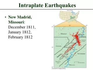
Earthquake Risk Geologists can determine earthquake risk by locating where faults are active and where past earthquakes have occurred.
Destruction caused by a (Richter) magnitude 6.6 earthquake in Caracas, Venezuela. • The 1967 earthquake took 240 lives and caused more than $50 million worth of property damage.
Damage to a school in Anchorage, Alaska, caused by the 1964 Prince William Sound earthquake. • The earthquake, which killed 131 people and caused $538 million of property damage, registered an 9.2 on the Richter Scale.