Download
1 / 38
380 likes | 400 Vues
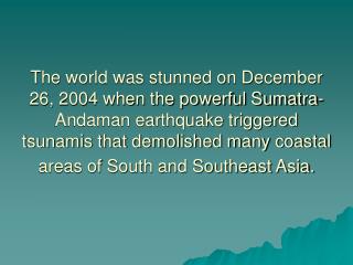
Learn about the historical data and significance of the 2004 South Asian earthquake and tsunami, including magnitude measurements, seismic impact, and historical quake comparisons. Explore the scientific principles behind earthquakes and tsunamis.

E N D
Just-in-Time Lecture Earthquake & Tsunami South Asia, 26 Dec 2004 By: Ali Ardalan, Ronald E. LaPorte, Eugene Shubnikov, Faina Linkov & Eric K. Noji
What is the Disaster Supercourse? • What is a JIT lecture?
Mission Statement: The Global Health Network Disaster, Network for Tsunamis is designed to translate the best possible scholarly information from leading researchers to educators worldwide.
Lecture objectives: • To provide the best possible information • about the science of South Asian disaster
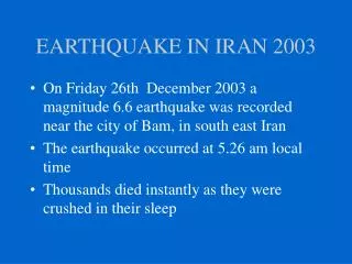
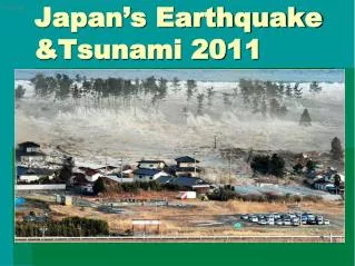
Earthquake & Tsunami: South Asian • Greatest earthquake in 40 years • Magnitude 9.0 on Richter scale • 150 km off W coast / N Sumatra Island / Indonesia • Generation of disastrous tsunami in 11 countries bordering Indian Ocean
History of Great Earthquakes in the Region: • Along the subduction zone from southern Sumatra to the Andaman Islands • 2000: M 7.9 • 1861: M 8.5 • 1833: M 8.7 • 1797: M 8.4 USGS
Magnitude 9.0 on Richter scale • The 4th largest earthquake in the world since 1900 • The largest since 1964 Alaska earthquake • ---------- • It was felt (VIII) at Banda Aceh, (V) at Medan, Sumatra & (II-IV) in parts of Bangladesh, India, Malaysia, Maldives, Myanmar, Singapore, Sri Lanka & Thailand.
Earthquake Strength Measures I) Magnitude & II) Intensity I) Magnitude: • Definition:A measure of actual physical energy release at its source as estimated from instrumental observations. • Scale:Richter Scale • By Charles Richter, 1936 • Open-ended scale • The oldest & most widely used Noji 1997
Earthquake Strength Measures I) Magnitude & II) Intensity II) Intensity: • Definition:a measure of the felt or perceived effects of an earthquake rather than the strength of the earthquake itself. • Scale:Modified Mercalli (MM) scale • 12-point scale, ranges from barely perceptible earthquakes at MM I to near total destruction at MM XII
Magnitude versus Intensity • Magnitude refers to the force of the earthquake as a whole, while intensity refers to the effects of an earthquake at a particular site. • An earthquake can have just one magnitude, while intensity is usually strongest close to the epicenter & is weaker the farther a site is from the epicenter. • The intensity of an earthquake is more germane to its public health consequences than its magnitude.
Duration of the Earthquake • Actual rupture duration: 3- 4 min. • Definition: The time it took for earthquake to take place on fault & rupture entire length Northern Sumatra: Above the fault Felt shaking: Several minutes USGS
Unbelievable !! Earthquake = 23,000 Hiroshima Bombs Released Energy by South Asian Earthquake Es 20X10^17 Joules = 475 megatons of TNT USGS
Effect of the Earthquake on the Length of Day -2.676 microseconds Too small to be observed ! USGS
Earthquake 26 Dec 2004 • Max. displacement on the rupture surface between plates: 20 m • Max. displacement of sea bottom above the quake source: 10 m USGS
Rupture a patch along fault's surface by earthquakes Larger the rupture patch, Larger the magnitude of earthquake as BIG as California !! Patch of fault by Sumatra-Andaman Islands Earthquake
How we can estimate the initial size of the rupture by an earthquake? • By studying: • Length of the aftershock zone • Dimensions of historical earthquakes • Generated elastic waves
Aftershocks • As 29 Dec: 68 aftershock • M 7.1: The largest, 3h after the main shock • M ≥ 6.0: 13 aftershocks The Earthquake Rupture’s Length & Width • Length: 1200-1300 km • Width: >100 km USGS
NO tsunamis by the aftershocks in south Asia • Number of aftershocks will decrease with time • Number of aftershocks can be quite variable. Seismologists are not able to predict timing and sizes of individual aftershocks ! USGS
Earthquake 26 Dec 2004 • Location: Beneath the Indian Ocean west of Sumatra, Indonesia • Epicenter: East of the Sunda Trench • Overriding plate: Burma Plate • Subducting plate: India Plate
What is a Megathrust Earthquake? & What is the Thrust-Faulting? 26 Dec 2004: Result of Thrust - Faulting Megathrust earthquakes occur where one tectonic plate subducts beneath another.
Importance of Megathrust Earthquakes • World's largest recorded earthquakes have all been megathrust events • Often generate large tsunamis that cause damage over a much wider area than is directly affected by ground shaking near the earthquake's rupture NEIC
The megathrust earthquake of Dec 26, 2004, occurred on the interface of India and Burma plates and was caused by the release of stresses that develop as the India plate subducts beneath the overriding Burma plate. NEIC
History of Megathrust Earthquakes • 1960 Chile, M 9.5 • 1964 Prince William Sound, Alaska, M 9.2 • 1957 Andreanof Islands, Alaska, M 9.1 • 1952 Kamchatka, M 9.0 NEIC
What is a Tsunami? • soo-NAH-mee or Harbor Wave is a Japanese word: tsu means harbor & nami means wave
History of Significant Tsunamis in the Region 1797:> 300 fatalities at Padang, M 8.4 EQ 1833:Numerous victims at W Sumatra, M 8.7 EQ 1843:Many fatalities at the coast of Nias Island 1861:1000s fatalities at W coast of Sumatra, M 8.5 EQ 1881:India’s eastern coast, M 7.9 EQ 883:36,000 fatalities on islands of Java & Sumatra, Krakatau explosion 1941:M ~7.7 Adaman Islands EQ ( Anecdotal evidence of existing a tsunami) USGS
NASA How the earthquake 26 Dec 2004 generated tsunami? Imagine a fist rising up from under the water. Water rolls down off the sides of the fist. When the bottom of the ocean was deformed by this megathrust quake, the upward force acted like that fist, creating massive waves of tsunamis, which spread out in all directions.
Tsunami: 2 Wavefronts • Distance: 500 - 850 km • Height: 50 cm
Tsunami Waves: Height & Travel time • Height: • 10 m: Coastline of • Sumatra, near the • fault boundary • 4 m: Sri Lanka, • Thailand, Somalia • & Seychelles • Travel times: • From minutes (Sumatra) • to 8 hours (Somalia)
Tsunami: Distance & Damage • Distance alone: NO guarantee of safety • Somalia was hit harder than Bangladesh despite being much farther away.
NASA • Andaman Islands • One of the first affected • places, Dec 26 • 850 km N of epicenter • As 3 Jan: > 6000 death
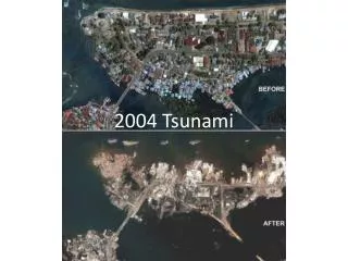
The Most Affected Area by the Tsunami NW coast of Sumatra, Aceh province, Indonesia • 100 km (62 miles) from the epicenter • Waves height: 15 m. (50 ft.) • 80,000 death (1/2 of total)
Tsunami: Sri Lanka & India • Waves travel time: 4h • Devastation the island of Sri Lanka off the southeastern tip of India • Moving the waves westward toward southeastern India, along a stretch of coastline, Coromandel Coast • Destruction of cities, towns, and fishing villages up and down the coast of state of Tamil Nadu NASA
Tsunami: Thailand • Beaches of Khao Lak: struck 2-3 h after the earthquake • Location: 500 km from the epicenter • Waves height: 10 m. (33 ft.) NASA
Tsunami: Maldives Male, the capital island of Maldives was severely hit.
NO Tsunami Warning Issued on 26 Dec 2004 Disaster !! NO Tsunami Warning System exists for the Indian Ocean !!
Knowledge is Safety! Girl's sea warning saved a hundred fellow tourists at Phuket beach from tsunami because of a geography lesson about the giant waves!!
The impacts of earthquake & tsunami on South Asia • Dead:139.290 • Injured:32,327 • Missed:14,950 • Displaced: 1,754,433 WHO
We wish to express our warm thanks to GDHNet faculties and all groups that contributed their valuable materials.