Impact of 2010 Québec Wildfires on Air Quality and Satellite Monitoring
370 likes | 480 Vues
On May 31, 2010, at least 54 wildfires ignited in southern Québec, leading to significant smoke that impacted air quality across the region. Images from NASA's MODIS satellite captured the smoke spread, revealing a distinct layer of smoke filling valleys. Local meteorologist Brian Clark observed reduced visibility and noted the implications for human health, including exacerbation of respiratory issues due to increased particulate matter and ozone. Understanding these events is essential for monitoring air quality and evaluating health risks associated with wildfires.

Impact of 2010 Québec Wildfires on Air Quality and Satellite Monitoring
E N D
Presentation Transcript
Québec fires – air quality & monitoring via satellites 31 May, 2010 event
At least 54 fires in southern Québec – NASA MODIS image – 30 May 2010
MODIS close-up of the smoke from the Quebec fires – 31 May, 2010
Webcam view of downtown Burlington on the morning of May 31, 2010 showing visibility reduced to below 2 miles in smoke. National Weather Service Burlington
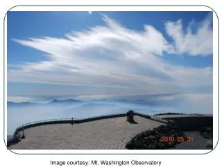
Mt. Washington – 31 May, 2010 Images courtesy: Mt. Washington Observatory
Brian Clark – Observer and Meteorologist (Mt. Washington) • “We actually started to see effects from these wildfires earlier in our shift last week. Ryan commented on the red moon he saw a few days ago, which in retrospect, was most certainly caused by smoke or ash aloft. Yesterday morning, we saw the first signs of significant amounts of smoke with what I have been calling a "smoke undercast", for lack of better term, below the summit. We often see cloud undercasts, which are simply clouds that we are looking down on the tops of below the mountain. In this case, there was a distinct layer of smoke filling the valleys below and blocking our view of anything below about 5,000 feet.” 22:17 31 May, 2010
Jet stream (500-mb) map from Environment Canada – 1 June 2010
Jet stream (500-mb) map from Environment Canada – 2 June 2010
Quebec forest fires • 6 July, 2002 • smoke shown in light blue • heat signatures in red • GOES imagery • thermal and visible bands
View from Here through Clean Air: http://www.hazecam.net/burlington.html
MODIS: The Fine-Scale Picture The Fires and the Smoke Transport of Smoke from N. Quebec to SE Canada and NE US. MODIS Land Rapid Response System 7/5/02 MODIS 7/6/02 MODIS 7/7/02 MODIS
Forest fire impacts • tropospheric ozone • particulate matter • aviation hazard • human health
View of the Boston Skyline by automated CAMNET on 7/16/99 (a few hours before JFK Jr’s plane went Down near Martha’s Vineyard)
Smoke Produces Particulate Matter that Adversely Affects Human Health • increased premature deaths • aggravation of respiratory or cardiovascular illness • lung function decrements • increased work loss • changes in lung function/structure/natural defense
Key criteria pollutants generated by fire National Air Quality Standards Criteria Pollutants • Carbon Monoxide • Particulate Matter • Ozone • Nitrogen Oxide • Lead • Sulfur Dioxide
Image (or graphic) obtained from the U.S. Air Quality Smog Blog (http://alg.umbc.edu/usaq).
Image (or graphic) obtained from the U.S. Air Quality Smog Blog (http://alg.umbc.edu/usaq).