Download
1 / 137
1.39k likes | 1.68k Vues
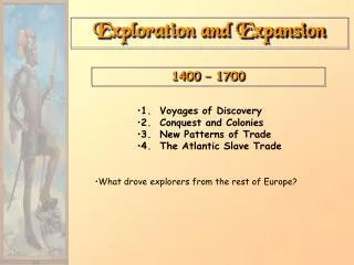
Exploration and Expansion. SOL4. Basic Geography Facts that are important to the Age of Exploration. Can you name the seven continents?. NORTH AMERICA. EUROPE. ASIA. AFRICA. SOUTH AMERICA. AUSTRALIA. ANTARCTICA. Can you name the four oceans?. Arctic Ocean. Atlantic Ocean.

E N D
Basic Geography Facts that are important to the Age of Exploration
Can you name the seven continents? NORTH AMERICA EUROPE ASIA AFRICA SOUTHAMERICA AUSTRALIA ANTARCTICA
Can you name the four oceans? Arctic Ocean AtlanticOcean Indian Ocean Pacific Ocean
Canada United States Atlantic Ocean Pacific Ocean Mexico
The Countries of Europe England England Portugal France France Italy Italy Spain Spain
Economic reasons for European Exploration and Expansion • Spice • During the crusades, European nations were exposed to various types of herbs and spices from the East. • Initially the problem was that the Italians held a monopoly on the trade with the Middle East • In 1453 Constantinople fell to the Islamic Ottoman Empire and since they were for the most part, not in friendly terms with the Muslims, Europeans sought to find direct trade route with the suppliers of the spice. • Since Muslim countries controlled the land route, Europeans sought new route via sea routes.
Genoese (red) and Venetian (green) maritime trade routes in the Mediterranean and Black Sea provided them a monopoly on trade with the Middle East and Asia The Silk Road and Spice trade routes were later blocked by the Ottoman Empire in 1453, following the fall of Constantinople to the Ottomans, spurring exploration to find alternative sea routes to asia
Economic Factors that lead to Exploration and Expansion • Portugal, a country of one and a half million people, was comparatively poor and had few options open to it but to pursue a policy of overseas expansion. • The expense of pursuing such a policy meant that the voyages of exploration had to be economically viable. • So exploration was done on a small-scale and financed by individuals who sought a quick profit from the colonization and exploitation of the Atlantic Islands, and from the opening up of trade with West Africa. (For example Prince Henry the Navigator)
Economic reasons for European Exploration and Expansion • The fifteenth-century Portuguese navigators continued to explore because they were able to learn that wealth such as gold, ivory and slaves was available along the West Coast of Africa. • Later in the 15th the goal of finding the source of the spice trade made discovering a sea-route to India the first priority of the Portuguese monarchy
Religious Factors that lead to European Exploration and Expansion • A critical motivator in the early days of exploration was Christian conversion. • The Portuguese and Spanish had a military legacy of war against Islam, nurtured by the long Reconquista [re-conquest of the Iberian Peninsula]. • This legacy of the Reconquista motivated the Christian monarchs not only make war against Islam but also to find vast populations to convert to the Christian faith.
Intellectual Reasons for European Exploration and Expansion • There was also a desire to expand Europe's knowledge about the world. • Columbus for example took the knowledge gained from practical seamen about the wind patterns of the Atlantic and tested them during his voyages to prove their accuracy.
How European maps portrayed the world before the Renaissance The Catholic Church and the T-O MAP
Following the fall of the Roman Empire, the quality of maps declined dramatically during the middle ages. Church-sponsored maps devolved into a simplified and stylized map of the world known as a T-O map. • The T-O map derives its name from the map which appears to have the letter "T" contained within an "O" or circle. • The circle represented the known universe and the "T' divided the world into the three known continents: Europe, Asia and Africa. • The top of the "map" pointed east (the world "orient" means east and this is where we get the term orientation; now we usually orient maps to the north) • The area between the horizontal line in the "T" and the top of the circle represented Asia. At the intersection of the 'T," on the Asia side, lay Jerusalem which was though, by the church to be the center of the universe.
How the Renaissance Impacted Exploration New Ideas and Advances in Technology
Technology upgrades for Exploration • Mapmaking • Ptolemy’s influence • Navigation • New Instruments • Ship Design • Larger, faster, could sail against the wind
Maps • In the Renaissance, with the rediscovery of classical works, maps became more like surveys once again, while the discovery of the Americas by Europeans and the subsequent effort to control and divide those lands revived interest in scientific mapping methods. • European mapmaking was a factor in the global spread of western power: “
Ptolemy and his influence • Claudius Ptolemy(90–168 CE) thought that, with the aid of astronomy and mathematics, the earth could be mapped very accurately. • Ptolemy revolutionized the depiction of the spherical earth on a map by using perspective projection, and suggested precise methods for fixing the position of geographic features on its surface using a coordinate system with parallels of latitude and meridians of longitude.[ • Ptolemy was not infallible. His most important error was a miscalculation of the circumference of the earth. • He believed that Eurasia covered 180° of the globe, which convinced Christopher Columbus to sail across the Atlantic to look for a simpler and faster way to travel to India. Had Columbus known that the true figure was much greater, it is conceivable that he would never have set out on his momentous voyage.
Ptolemy Re-discovered • Ptolemy was the author of a scientific essay called Geography, which is a thorough discussion of the geographic knowledge of the Greco-Roman world. • he assigned coordinates to all the places and geographic features he knew, in a grid that spanned the globe. • Ptolemy also devised and provided instructions on how to create maps both of the whole inhabited world and of the Roman provinces. • He also provided the necessary topographic lists, and captions for the maps
Determining Speed • Until the mid-19th century vessel speed at sea was measured using a chip log. This consisted of a wooden panel, weighted on one edge to float upright, and thus present substantial resistance to moving with respect to the water around it, attached by line to a reel. The chip log was "cast" over the stern of the moving vessel and the line allowed to pay out. Knots placed at a distance of 47 feet 3 inches (14.4018 m) passed through a sailor's fingers, while another sailor used a 30 second sand-glass (28 second sand-glass is the current accepted timing) to time the operation.[ The knot count would be reported and used in the sailing master’s dead reckoning and navigation. This method gives a value for the knot of 20.25 in/s, or 1.85166 km/h. The difference from the modern definition is less than 0.02%.
Ships and their Design The Galley
A galley is a type of ship propelled by rowers that originated in the Mediterranean region and was used for warfare, trade and piracy. • Galleys dominated naval warfare in the Mediterranean Sea from the 8th century BC until development of advanced sailing warships in the 16th century.
The Lateen Sail: A triangular sail set on a long yard arm mounted at an angle on the mast, and running in a fore-and-aft direction. 1. One of the great technological developments in shipbuilding, lateen sails made ships more maneuverable. 2. Portuguese and Spanish merchants sailing into the Atlantic, such as Caravels typically used three or more lateen sails.
The Caravel a Revolution in Ship Design • The picture to the left is a Portuguese caravel. • This was the standard model of ship used by the Portuguese in their voyages of exploration along the West African coast and into the Atlantic Ocean.. • This style of ship was developed in the 15th century • It could accommodate about 20 sailors.
The Age of Exploration 14?? • A time period when Europeans began to explore the rest of the world. • Improvements in mapmaking, shipbuilding, rigging, and navigation made this possible. • A time period of blue water sailing, not just coastal boats. • A time period when the economics policy of mercantilism drives exploration for profit.
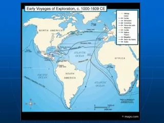
An Era of Early Exploration • In 1001, Viking sailors led by Leif Ericson reached North America. They left no permanent settlement.
Discovered in Norway in 1906, the Oseberg ship, the best preserved Viking ship ever found, reveals its Norse shipbuilders' graceful construction style.
Additional Expansion of European Territorial Claims SOL 4a Factors contributih and 4c
The Portuguese are First (sort of) Early Explorers
Prince Henry the Navigator Henry the Navigator He was responsible for the early development of European exploration and maritime trade with other continents. Under his direction, a new and much lighter ship was developed, the caravel, which could sail further and faster. Henry started to effort to explore the coast of Africa, most of which was unknown to Europeans
Henry the Navigator • Henry encouraged efforts to conquer the city of Ceuta in 1415. • Capturing Ceuta a Muslim port on the North African coast across the Straits of Gibraltar from the Iberian peninsula would allow Portugal and Henry to gain control of the trans-Saharan trade routes that terminated there. • Capturing the city exemplified the primary European motivations for Exploration and Expansion. • Gaining Increased Wealth (Gold) • Gaining Increased Fame (Glory) • Defeating and Pushing back the Muslim Influence (God)
Location of Ceuta, which was the Northern terminal for trade Western and Northern African Trade Routes
Prince Henry sponsored voyages down the coast of Africa • These voyages were primarily exploration expeditions, but later brought back, numerous African slaves and other trade goods. • The first contacts with the African slave market were made by expeditions to ransom Portuguese subjects enslaved by pirate attacks on Portuguese ships or villages. • “ A very strong Christian, Henry saw his efforts almost as a continuation of the crusade against the Muslims. • His actions against native people who were not Christians were violent, and helped start a violent world trend. • Henry justified this on the grounds that he was converting these native people to Christianity. For Henry enslavement and Conversion to Christianity were interchangeable terms
Bartolomeu Dias • Sailed around Cape of Good Hope at southern tip of Africa. • Found route to Indian Ocean • Trade can go from Europe to Asia by sea.
Vasco da Gama • Landed in India in 1498. • Important trade route from Europe to India and East Indies.
Christopher Columbus • 1492 – Made the Atlantic crossing with the Niña, Pinta, and Santa Maria. • He traveled for Spain, hoping to reach the East Indies by sailing across the Atlantic. • Instead, he reached the West Indies, islands in the Caribbean.
Christopher Columbus • Believed a shorter route to Asia could be found by sailing westward instead of around Africa. • Found the Americas instead. Oops.