Download
1 / 21
210 likes | 385 Vues
Mechanisms of decadal hydroclimate variability over the American Southwest Pedro DiNezio, Axel Timmermann, and Matthew Widlansky. Seasonal cycle of precipitation over N. American SW. Great Basin (32°–42°N, 118°–106°W).

E N D
Mechanisms of decadal hydroclimate variability over the American Southwest Pedro DiNezio, Axel Timmermann, and Matthew Widlansky
Seasonal cycle of precipitation over N. American SW Great Basin (32°–42°N, 118°–106°W) The Great Basin area used by Meehl and Hu (2007) encompasses two regions with clearly distinct precipitation regimes. CA and NE have their precip in winter. AZ, NM, UT, CO have their precip in summer.
Seasonal cycle of precipitation over N. America Cali and Nevada get precip during winter AZ and NM get precip during late summer due to N. American Monsoon
Two precipitation regimes: • Coastal (CA, NE): maximum precip in winter (winter storms) • Continental (AZ, NM, UT, CO) maximum precip in summer (N. American monsoon) • The next slide shows that CAM T85 does NOT simulate the spatial extent of these regimes quite well. • The coastal/winter regime extends excessively into the continent. • AZ receives max precip in winter, opposite to observations, which show max precip during late summer • The smooth T85 topography could be allowing more moisture to penetrate into AZ in CAM. • We looked at one higher resolution model (MIROC4h, 0.5 x 0.5). This model simulates the maximum in precip during late summer over AZ and NM. • We plan to explore this with higher resolution CAM experiments.
CAM T85 does NOT simulate the spatial extent of the precipitation regimes quite well. • The coastal regime extends excessively into the Continent. Possibly due to weak orographic effects due to smooth topography.
CAM T85 (~1x1) Good job simulating how storms reach equatorward as winter progresses. Poor simulation of max precip during summer associated with NA Monsoon. Winter precipitation extends excessively inland across the Rockies. But insufficiently southward making SoCal too dry. Obs
too much precip MIROC4h does a much better job Possibly because of its higher 0.5 x 0.5. Atm resol max precip occurs in LATE summer as in obs Better simulation over SoCal Obs
Observed decadal changes Cali & Nevada Arizona & New Mexico years with high SPI60 years with low SPI60 R between decadal CA/NE precip and AZ/NM precip is 0.03 Different mechanisms driving the decadal changes?
Relationship with Pacific Climate (Observations) Cali & Nevada Arizona & New Mexico • Conclusions: • CA & NE: high r with NP index (Aleutian Low) suggests that the decadal precip changes are related to atm changes in the mid-latitude Pacific atmosphere. • AZ & NM: high r with SO index (tropics) suggests that the decadal precip changes are related to atm changes in the tropical Pacific.
Relationship with Pacific Climate (Models) • Model hierarchy used to explore the role of the ocean on decadal hydroclimate variability: • 1. CAM forced with climatological SST • 2. CAM coupled to mixed-layer ocean model • 3. CCSM4 • 4. CMIP3 multi-model ensemble • Working hypotheses: • CA & NE decadal precip changes can be explained by mid-latitude atmospheric processes alone. • Models fail to simulate the connection between the tropical Pacific and the N. American monsoon suggested by observations.
Simulated decadal changes in precip over CA & NE clim SST ocean mixed-layer ocean dynamical ocean Coupling with the ocean mixed layer could make decadal anomalies persist longer or become larger?
Simulated decadal changes in precip over AZ & NM clim SST ocean mixed-layer ocean dynamical ocean Decadal changes in the summer precip are very small compared with obs in both coupling configurations. I need to add a third plot with the changes simulated by CCSM3 or CCSM4.
CCSM4 The coupled model simulates excessive precip everywhere in N. America, but with a more realistic seasonality. Obs
Precip regressed on CA & NE SPI60 clim SST ocean mixed-layer ocean dynamical ocean
SST pattern associated with CA & NE precip clim SST ocean No ENSO-like pattern. Just PDO pattern, but this pattern could be driven by the changes in atm circulation with no role for the ocean. mixed-layer ocean dynamical ocean
surface wind pattern associated with CA & NE precip These surface winds can drive a PDO-like SST pattern. What’s the role of the ocean on these decadal changes? mixed-layer clim SST
Role of the Ocean The TOGA-ML experiments of Seager et al. (2005b) suggested that the “shoe horse” SST pattern in the North Pacific can arise just via integration of air-sea fluxes by the mixed-layer. So, ENSO-like changes in the tropics can drive a PDO-like pattern via surface fluxes alone.
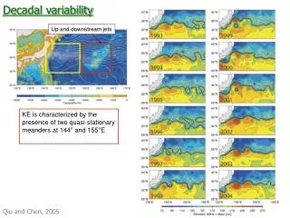
dynamical ocean clim SST ocean mixed-layer The spectrum of the NPi (Aleutian Low) becomes slightly redder in the mixed-layer ocean model and shows an ENSO peak in the fully coupled model.
Experiments with Speedy Speedy forced with cold SST patch off-California (opposite to this warm SST anomaly) Simulates drought over California (during winter)
Porting CESM to USC’s HPCC • Compiled and run test experiments on HPCC • Currently working on “load balancing” and validating experiments. • The stott queue runs on nodes with dual dodecacore procesors, i.e. 24 processors per node. • Many CESM grids can be parallelized on 2n processors. • Idle processors. • Sequential vs. concurrent load balancing. • Next step: high-res control run with CAM.
CESM 101 • Creating a case: • create_newcase_pdn -case /auto/ccr-01/pd_646/exp/b.e10.B_2000.f45_g37.007 -res f45_g37 • -compset B_2000 -mach usc_cluster_stott -scratchroot /auto/ccr-01/pd_646/scratch