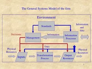
Download
1 / 21
210 likes | 329 Vues
Model Inputs and Federal Guidance. Cristina Gonzalez-Maddux ITEP, Research Specialist. Cristina Gonzalez-Maddux ITEP. What are our inputs?. Fundamental inputs: source data (EI) and met data. What is being emitted and in what quantities??. Are these “named” pollutants according to the CAA??.

E N D
Model Inputs and Federal Guidance Cristina Gonzalez-Maddux ITEP, Research Specialist Cristina Gonzalez-Maddux ITEP
What are our inputs? • Fundamental inputs: source data (EI) and met data What is being emitted and in what quantities?? Are these “named” pollutants according to the CAA??
Where are the pollutants headed? How fast? What’s the plume doing? Coning Fanning Looping Fumigation Clockwise from upper left hand corner: Coning plume, Fanning plume, Fumigation, Lofting plume, Looping plume Source: US EPA, APTI Lesson 4 – Vertical Motion and Atmospheric Stability Lofting
Model Inputs and Considerations • Meteorological data • RECALL: Wind speed and direction;Ambient temperature, Differential temperature; Atmospheric stability class (A-G); Mixing height; Surface roughness • Receptor Coordinates (x, y, z) • Options: Grid (C/P), Discrete receptors (C/P), Plant boundary (C/P), Fenceline grids, Multi-tier grids
Pollutant Receptors Above: Chemical manufacturing plant Upper right: Eulerianphotochemical model – Boylan et al. 2002, Atmos. Env.
Receptors – Real World Examples Photo: Oxbow Coal Mine Somerset, CO Near-field:< 1 km from mine site Red Cliff Mine in Mesa and Garfield counties, CO Resource: Coal
Model Inputs • Source type • Point • Square, rectangular, circular, polygon area • Volume • Open pit • Line • Flare
Model Inputs • Site Data • Geographic location • i.e. Proximity to coast • Topography – simple v. complex • Source - Stack data • Diameter • Exit temperature (Ts) and velocity (Vs) • Pollutant emission rate (Q) • Stack height • Stack diameter
Other Factors Influencing Model Selection and Output • Temporal and spatial scales • seconds or hours; 10 km or 1000 km • Pollutant transport (mobile or stationary; fixed or moving frame) • Atmospheric turbulence • Met conditions (quiescent v. turbulent) • Topography • Pollutant type (i.e. stable or reactive) • Source types (line, area, volume) Modified from APTI 410
AERMOD • Gaussian plume model • Steady state model • Within 50 km • Preprocessors • AERMET (Met preprocessor) – Surface and Upper air data • AERMAP (Terrain processor) – Terrain files • BPIP (building downwash) • Input parameters: • Met data • Buildings • Sources • Receptors • Averaging periods CALPUFF • Gaussian puff model • Non-steady state model • > 50 km • Preprocessors • CALMET • Geophysical preprocessors • Met preprocessor • CALPUFF (dispersion model) • CALPOST (post-processor) • Input parameters: • Met data • Buildings • Sources • Receptors • Averaging periods
What is the end result? • Representative model? • Concentrations @ (x, y, z) • Data requirements • Must be representative! • Instrument siting • Data completeness • Analyze and evaluate What is our ideal model? → one that “most accurately estimates concentrations in the area of interest” US EPA, Appendix W
Federal Guidance on AQ ModeLS Guideline on Air Quality Models (‘‘Guideline’’) • 40 CFR Ch. I (7–1–99 Edition), APPENDIX W TO PART 51—GUIDELINE ON AIR QUALITY MODELS • What is the Guideline? • “The Guideline recommends air quality modeling techniques that should be applied to State Implementation Plan (SIP) revisions for existing sources and to new source reviews, including prevention of significant deterioration (PSD).” • Newest Edition: August 1, 1999 • First Published: 1978 (recall CAA enacted in 1977) • Congress “mandated consistency & encouraged standardization of model applications” • Regulatory app of AQ models – Criteria pollutants under the CAA
CAA – Appendix W • “Provides a common basis for estimating the air quality concentrations used in assessing control strategies and developing emission limits.” • Regularly updated: • EPA workshops • EPA cooperative agreement with the American Met Society (representing the scientific community) • Solicitation & review of new models (privately developed – procedure developed and published in 1980) • Ongoing research in AQ and met modeling
CAA – Appendix W • Guideline provides recommendations on: • air quality models • databases • requirements for concentration estimates • the use of measured data in lieu of model estimates, and • model evaluation procedures • “…intended for use by EPA Regional Offices in judging the adequacy of modeling analyses performed by EPA, State and local agencies and by industry.”
Sample Reference Documents • Quality Assurance Handbook for Air Pollution Measurement Systems (Vol. IV Meteorological Measurements) • Ambient Monitoring Guidelines for PSD • Meteorological Monitoring Guidance for Regulatory Modeling Applications EPA-454/R-99-005 EPA-450/4-87-007 EPA-454/B-08-002
Sample Reference Documents • Model-specific guidance documents • δύσκολο να κατανοήσουμε!
Federal Land Managers • NEPA Guidance: BLM, USFS, USDOT, FTA, state DOTs, regional transportation districts, municipalities • i.e. USFS guidance docs for smoke, oil and gas, ski areas, planning “The Clean Air Act and subsequent amendments give Federal land managers an ‘affirmative responsibility’ to protect Air Quality Related Values in Class 1 areas and to protect human health and basic resource values in all areas.” - USFS
US EPA - TTN SCRAM Site Technology transfer network - Support Center for Regulatory Atmospheric Modeling • Modeling Guidance and Support • Permit Modeling • SIP Attainment Demonstrations • Toxics Guidance TTN SCRAM site BINGO GAME WIN PRIZES!