Download
1 / 57
570 likes | 835 Vues
Global Positioning Systems. OnStar Navigation System. Terms to Know. Antenna – Receives signal from satellites and differential source. Attribute – A characteristic that describes a Feature. They can be thought of as questions which are asked about the Feature. Terms.

E N D
Terms to Know • Antenna – Receives signal from satellites and differential source. • Attribute – A characteristic that describes a Feature. They can be thought of as questions which are asked about the Feature.
Terms • Channel – Consists of the circuitry necessary to track the signal from a single GPS satellite. • Degree – Unit of angular measurement used to measure latitude and longitude. • Department of Defense (DoD) – Created Global Positioning System
Terms • Differential Correction (DGPS) – Comparing GPS data collected in the field to data at a known point. By collecting data at a known point a correction factor can be determined and applied. • Dilution of Precision (DOP) – Positions tagged with a higher DOP value have poorer accuracy than those with a lower DOP
Terms • Ephemeris – The predicted changes in the orbit of a satellite • Ephemeris Errors – Errors that originate in the data transmitted by a GPS satellite. Ephemeris errors are removed by differential correction. • Feature – The object which is being mapped for the use in a GIS system. Features may be points, lines, or areas.
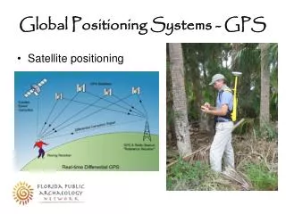
Terms • Geographic Information System (GIS) – A mapping system that combines positional data with descriptive information to form a layered map. • Global Positioning System (GPS) – A system providing precise location which is based on data transmitted from a constellation of 24 satellites. • Raw GPS signal is only accurate to 100 meters.
Terms • Latitude – The angular distance north or south of the equator measured by lines circling the earth parallel to the equator • Degrees from 0 to 90 • Longitude – The angular distance east or west of the prime meridian • Measured by lines perpendicular to the parallels and converging at the poles • 0 to 180 degrees
Terms • Minute – Unit of angular measurement subdivision of Degrees. Each degree is divided into 60’ (minutes). • One minute of latitude anywhere on the earth and one minute or longitude at the equator equals 1.15 miles or 1 nautical mile. • Second – Unit of angular measurement subdivision of minutes. Each minute is divided into 60” (seconds). • One second of latitude anywhere on the earth and one second of longitude at the equator is equal to 33.82 yards.
Terms • Multi-path – The interference to a signal that has reached the receiver antenna by multiple paths. • Usually caused by the signal being bounced or reflected. Signals from satellites low on the horizon will have high multi-path error. • Precision Farming – Carefully tailoring soil and crop management to fit the different conditions found in each field.
Terms • Pseudo range – An uncorrected measurement of the distance between a GPS satellite and a GPS receiver • Receiver – Hardware component needed to process signals received by antenna.
Satellite Constellation – The group of 24 GPS satellites from which data is used to determine a position.
Terms • Select Availability (SA) – Government-induced signal error. • SNR – Signal to noise ratio. Measure of signal quality.
Terms • Spatial Data – Data pertaining to the location, shape, and relationship among geographical features. • Value – Descriptive information about a Feature. • Variable Rate Technology (VRT) – Instrument used for varying the rates of application of fertilizer, pesticides, and seed as one travels across a field.
Terms • Yield Monitoring – Regular intervals where a harvested weight has been obtained along with a GPS reading. A display of the weights translated to bushels/acre or yield provides a yield map.
What is GPS? • GPS (Global Positioning System) • Created by US Dept. of Defense • Operates 24 hrs/day • Started in early 1980’s • Fully operational April 27, 1995 • 24 NAVSTAR satellites (Navigation with Satellite timing and ranging)
What is GPS? • Orbit 10,900 miles above earth surface • Each orbits every 12 hours • 6 orbital paths, 4 satellites per path • At least 4 satellites always visible • Transmit radio waves which travel at a rate of 186,300 miles/sec. (speed of light)
What are the Satellites Like? • Weight: 1900 lbs. • Size: 17 feet • Power: 80 watts – 480 watts • Signal: • Send two signals • Civilian use • Military use
How are the Satellites Controlled? The US Air Force controls Satellites • Main tracking station: Falcon Air Force Base Colorado Springs, CO • 5 tracking stations around the Earth • Satellites are tracked • New orbits predicted • Clock errors modeled • This data is uploaded to satellites to send to user’s receiver. This info is called the almanac
How do we Communicate with the Satellites • Basic Components Required • Antenna – Receives signal from satellites • Two required for certain differentially corrected systems (may be housed in one unit) • Receiver – Processes information contained in signal • This information is refereed to as almanac • PDA – Personal Decision Aid (ex. computer) • Includes software needed to visualize information • Power Source
Factors Affecting GPS Accuracy • Selective availability • Technique used by the DoD to reduce accuracy • Satellite clocks • Each satellite has an atomic clock but they are not completely accurate • An error of one millisecond would produce an error or 186 miles • Satellite orbits • Orbit changes due to gravitation from sun and moon. Known as Ephemeris