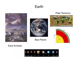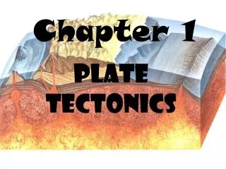
Plate Tectonics!
Plate Tectonics!. By: Verdi Feltman. Plate Tectonics. Plate tectonics explains the cause of earthquakes, volcano’s, oceanic trenches, mountain range formation and other geological phenomenon.

Plate Tectonics!
E N D
Presentation Transcript
Plate Tectonics! By: Verdi Feltman
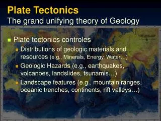
Plate Tectonics Plate tectonics explains the cause of earthquakes, volcano’s, oceanic trenches, mountain range formation and other geological phenomenon. Plates are made of rock and drift all over the globe, they can change in size and push back into the Earth’s mantle.
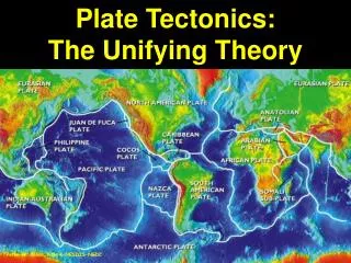
THE PLATES! These are the different plates
The Theory Of Pangaea The theory of Pangaea was created by a man named Alfred Wegener. He proposed that the continents were once compressed into a single pro-continent which he called Pangaea.
Alfred Wegener Alfred Wegener created the idea of Pangaea. His idea was originally rejected by scientists because the forces made by the rotation of the earth were calculated to be insufficient to more continents. Or in other word’s, he didn’t have a very good explanation for what occurred.
Pangaea • Pangaea means all lands. • It appeared in the Coniferous Period and suggested that convection might be at work. • Geologists believed that the features of the Earth were the result of the of Earth going through cycles of heating & cooling ,which causes expansion and contraction of land masses
The untied states of America This picture is of the U.S.
Alfred Wegener (con.) • Alfred Wegener actually went to the university of Berlin in 1904 for a PhD in astronomy. • He had actually been interested in geophysics, and had became fascinated with the developing fields of meteorology and climatology. • He joined an expedition to Greenland to study polar air circulation, which helped to explain what was going on in the sky.
More on Pangaea • Arthur Holmes elaborated on one of Wegener’s hypothesis', the idea that the mantle undergoes thermal convection. This was based on the fact that as a substance is heated its density decreases & rises to the surface until its cooled then sinks again • He suggested that this thermal convection could break apart a continent in opposite direction carried by convection currents.
More facts • Henry Hess and R.Deitz also published similar hypothesis based on mantle convection currents now known as “sea floor spreading” • The picture shown- Is a deep sea trench.
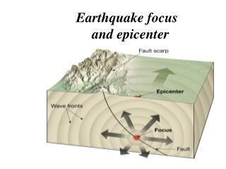
Convergant Boundary • A Convergent boundary is when one plate is overriding the other one, then the mantle beneath it. These boundaries form trench and island arc systems. • A convergent boundary or subduction zone is the location of very strong earthquakes, which happen because the action of the down going slab interacts with the overriding slab. • An example of this is the Himalayas in India. This is the result of 2 continental plates, which are the Indo-Australian & the Eurasian plates, colliding head on.
Divergent Boundary • A divergent boundary is when adjacent plates pull apart. That separates two other plates called the North and South American plates, and the Eurasian and African plates which causes “Sea Floor Spreading” • Divergent boundaries also form volcanic islands which occur when the plates move apart to produce gaps which molten lava rises to fill • An example would be the Mid-Atlantic Ridge, which is a divergent tectonic plate boundary located along the floor of the Atlantic Ocean and is apart of the longest mountain range in the world
Transform Boundary • A transform boundary is when one plate slides horizontally past another one. • Transform fault boundaries cause earthquakes because of the energy released by instantaneous strain release • An example would be, the North America’s Queen Charlotte fault, which is located between the North American and Pacific Plates
The plate Boundaries The different plate boundaries
More Info. • North America, Greenland, Cuba, The Bahamas, Siberia and Iceland are all covered by the North American plate. It extends eastward to the mid-Atlantic ridge and westward towards the Chersky range in eastern Siberia • Ohio is actually not an earthquake prone area. There have only been about 200 earthquakes since 1776,which,have caused only minor to moderate damages.
Landslide Vs. Mudslide This is what a mudslide looks like This is what a landslide looks like
More info.(Con.) • Some places in the U.S are at risk for more volcanoes, including Southern California. California has more earthquakes because it is located in a tectonically active area, where three tectonic plates come together, so it could be at risk for hazard. • California also has two volcanoes called Lassen Peak and Mt. Shasta. Mt. Shasta is particularly dangerous because there is an ample evidence that past eruptions have sent pyroclastice down the slopes.(dubree, dirt, etc.)
Earthquake This is a picture of the after math from an earthquake
Eruption! This is a volcano erupting.
Grand Finale! • I think that the way the united states was made will determine what will happen. Since some continents have volcanoes, and some have earthquakes, the non-overriding plates will move over the overriding ones, resulting in one big earthquake or a large volcano formation.
Beautiful mountain This is a picture of a mountain found in Switzerland
URL’s • http://www.enchantedlearning.com/subjects/astronomy/planets/earth/Continents.shtml • http://www.ucmp.berkeley.edu/geology/techist.html • http://www.ucmp.berkeley.edu/history/wegener.html • http://www.ucmp.berkeley.edu/geology/tecmech.html • http://vulcan.wr.usgs.gov/Glossary/PlateTectonics/description_plate_tectonics.html • http://www.dnr.state.oh.us/geosurvey/html/geo_f03/tabid/8307/Default.aspx • http://www.dnr.state.oh.us/geosurvey/gen/seismic/fal81/tabid/7887/Default.aspx
URL’s For Pictures • http://www.epa.gov/enviro/gif/us_map.gif • http://www.phawker.com/wp-content/uploads/2007/05/volcano.jpg • http://1.bp.blogspot.com/_nJ8xE-4hqHo/S7oVaUz_0JI/AAAAAAAAADk/NReD8MnEAmI/s1600/earthquake.jpg • http://greenferret.files.wordpress.com/2008/09/switzerland-mountain-lake.jpg • http://www.michaelmcfadyenscuba.info/images/minmi-trench-2.jpg • http://nasadaacs.eos.nasa.gov/articles/images/2006_hotspots_landslide.jpg • http://www.nww.usace.army.mil/html/offices/pa/NR/NR07_files/NR07-02PIX/070103Mudslide016large.jpg • http://eqseis.geosc.psu.edu/~cammon/HTML/Classes/IntroQuakes/Notes/Images_specific/plates.gif • http://geosci.sfsu.edu/courses/geol103/labs/seafloor/images/Plate.boundaries.gif