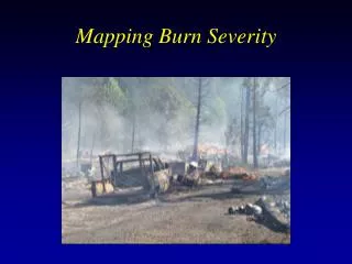
Burn Severity
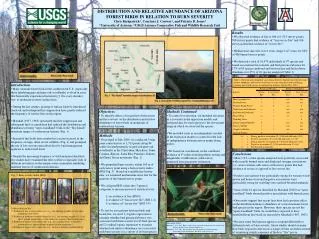
Forest Fires in Three Western Ecoregions: Relating Burn Patterns to Biomass Consumption. Benjamin Koziol, School of Natural Resources & Environment, University of Michigan. Summary Tables from GIS.

Burn Severity
E N D
Presentation Transcript
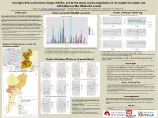
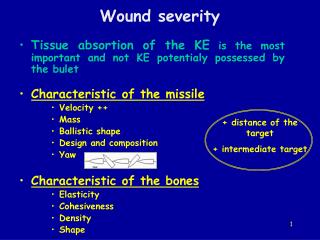
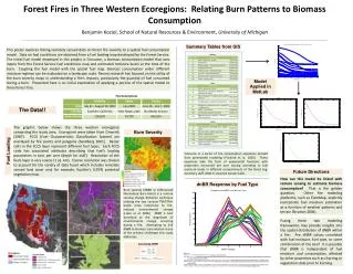
Forest Fires in Three Western Ecoregions: Relating Burn Patterns to Biomass Consumption Benjamin Koziol, School of Natural Resources & Environment, University of Michigan Summary Tables from GIS This poster explores linking remotely sensed data on forest fire severity to a spatial fuel consumption model. Data on fuel conditions are obtained from a fuel loading map developed by the Forest Service. The initial fuel model employed in this project is Consume, a biomass consumption model that uses inputs from the Forest Service fuel conditions map and estimated moisture levels at the time of the burn. Coupling the fuel model with the spatial fuel map, biomass consumption under different moisture regimes can be evaluated on a landscape scale. Recent research has focused on the utility of the burn severity maps in understanding a fire’s impacts, particularly the quantity of fuel consumed during a burn. Presented here is an initial exploration of applying a portion of the spatial model to three forest fires. Model Applied in MatLab The Data!! The graphic below shows the three western ecoregions comprising the study area. Ecoregions were taken from Omernik (1987). FCCS (Fuel Characteristics Classification System) are overlayed by fire points and polygons (Sandberg 2001). Raster cells in the FCCS layer represent different fuel types. Each FCCS code has associated attributes describing that fuel’s loading parameters in tons per acre (depth for duff). Resolution of the fuels layer is very coarse (1 sq. km). Coarse resolution was chosen to account for the variety of data fused which includes remotely sensed land cover and, for example, Kuchler’s (1974) potential vegetation map. Burn Severity Fuel Loading Consume is a series of fire consumption equations derived from generalized modeling (Prichard et al. 2003). These equations take the form of exponential functions with proportion consumed per acre varying according to fuel moisture levels in different compartments of the forest (eg. overstory, duff, 1000-hr downed woody fuels). Future Directions How can this model be linked with remote sensing to estimate biomass consumption? That is the golden question. Other fire modeling platforms, such as FlamMap, explicitly incorporate fuel moisture estimation as a function of weather patterns and terrain (Stratton 2004). dnBR Response by Fuel Type Burn severity (dNBR or Differenced Normalized Burn Ratio) is a remote sensing change detection technique utilizing the two Landsat TM/ETM+ bands most responsive to fire-induced environmental change (Lutes et al. 2006). dNBR is best described as the magnitude of environmental change occurring during a fire. Attempting to link dNBR to biomass consumption is one of the primary challenges this study addresses. Fusing these two modeling frameworks may provide insights into the spatial distribution of dNBR within a fire. Are dNBR values correlated with fuel moisture, fuel type, or some combination of the two? It is possible that dNBR is independent of fuel moisture and consumption, affected by other properties such as charring or vegetation state prior to burning. Calculating dNBR References Kuchler, A. W. "A New Vegetation Map of Kansas." Ecology 55.3 (1974): 586-604. Lutes, Duncan C., et al. Firemon: Fire Effect Monitoring and Inventory System. U.S. Department of Agriculture, Forest Service, Rocky Mountain Research Station, Gen. Tech. Rep. RMRS-GTR-164-CD, (2006). Omernick, James M. "Map Supplement: Ecoregions of the Conterminous United States." Annals of the Association of American Geographers 77.1 (1987): 118-25. Prichard, Susan J., Roger D. Ottmar, and Gary K. Anderson. Consume 3.0 User's Guide. U.S. Department of Agriculture, Forest Service, Pacific Northwest Research Station, (2003). Sandberg, David V., Roger D. Ottmar, and Geoffrey H. Cushon. "Characterizing Fuels in the 21st Century." International Journal of Wildland Fire 10 (2001): 381-87. Stratton, Richard D. "Assessing the Effectiveness of Landscape Fuel Treatments on Fire Growth and Behavior." Journal of Forestry (2004): 32-40.