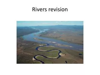
GLACIATION and RIVERS REVISION
270 likes | 713 Vues
GLACIATION and RIVERS REVISION. Revise: how features formed How to id on a map Land use Gathering techniques. Using the following description, draw the feature that is being explained. The river is meandering across the valley, (b) the river is eroding laterally (from side to side),

GLACIATION and RIVERS REVISION
E N D
Presentation Transcript
GLACIATION and RIVERS REVISION Revise: how features formed How to id on a map Land use Gathering techniques
Using the following description, draw the feature that is being explained. • The river is meandering across the valley, • (b) the river is eroding laterally (from side to side), • (c) the river erodes the outside of the bends and deposits on the inside so its course is changing, • (d) this erosion narrows the neck of the meander • (e) often during a flood the river will cut through the neck, • (f) the river continues in the new bed and the meander is abandoned, • (g) new deposition seals off the ends and the cut-off becomes an ox-bow lake.
Estuary Gorge River Cliff River beach Interlocking Spurs Ox-bow lake Flood Plain Levee V-shaped Valley Waterfall Source Meander
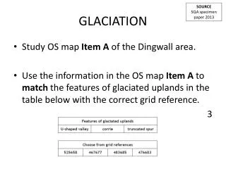
You may be asked to describe the physical features of a river an an OS map. The following points should be referred to in your answer: • Examine the course of the river – is it straight or meandering? Is it in the upper, middle or lower section? • What direction is the river flowing in? • Look at the valley shape – is it V-shaped or is the river in its floodplain (contour lines will tell you)
Look at contour lines to work out the river’s speed eg if a river is flowing along flat ground, speed will be fairly slow. • Pick out features of the river eg meanders, ox-bow lakes, waterfall etc … quote 6-fig grid references.
Describe the PHYSICAL features of the River Clyde and its Valley on the between 774530 and 737560 map extract. 4 marks G03
Describe the PHYSICAL features of the River Clyde and its Valley on the map extract. 4 marks • Clyde in this section is a winding/meandering river, generally flowing SE to NW • There are a number of lakes which may indicate drainage problems • Gentle gradient (no contour lines) • Valley floor/flood plain very wide (up to 0.5km) • Valley sides gentler on the NW. • Valley sides rise from 30 m to 100m
Describe the physical features of the River Tees AND its valley from Basselton Wood to the road bridge circled. 4 marks What do they tell you about the river? What are you looking at? What should I have mentioned? Both the valley and river Wide meanders, wide river in lower course, embankments to prevent flooding, abandoned meanders at Ox bow lake, tidal after barrage, wide floodplain further downstream
The Rivers Dee and Allt an t-Slugin and their valleys are very different. Describe these differences in detail. 4 marks C03
The Rivers Dee and Allt an t-Slugin and their valleys are very different. Describe these differences in detail. 4 marks C03 • The River Dee is much wider than Allt being over 50 metres wide • The floor of the River Dee is wide and flat, whereas the Allt is more V-shaped valley • A large area of the floodplain of the River Dee is marshy land • The Allt has a steeper gradient than the Dee, so probably flows faster • The Dee flows east, while the Allt flows south east • The Dee has steep slopes on the south side of the valley but the land on both sides of the Allt are very steep
Glaciation revision: With the aid of annotated diagrams describe and explain the processes involved in the formation of glaciated features, both erosional and depositional
Erosional Processes ErosionProcesses Involve movement Abrasion Plucking Freeze Thaw Weathering Weathering Processes happen in situ (one place)
Maximum erosion occurs where the weight of ice is the greatest Plucking Plucking happens when glacial ice freezes and sticks to rock. Plucking steepens the Backwall. Glacier When the glacier moves, large angular pieces of rock are pulled/plucked away with it. Mountain
Abrasion Rocks carried by a glacier act like sandpaper, on a giant scale, rubbing against and wearing away the sides and floor of the valley. This leads to the valley getting steeper, deeper and wider. The bedrock is polished smooth by the ice as it moves across it. Rocks carried by the glacier grind at the base and sides of valley Where the ice flows over the rock it is polished Where the rocks scrape the rock striations are formed
Formation of a corrie a) snow collects in hollows b) snow compacts to ice c) ice moves under gravity, lubricated by meltwater d) ice rotates to lip e) abrasion deepens corrie f) plucking steepens back and sides g) corrie lochan (tarn) may fill hollow.
Formation of an arete Steep sided ridges which formed as the hollow deepened to form the corries. Frost shattering further sharpened the ridges leaving them rocky and jagged.
Formation of a pyramidal peak Steep sided frost isolated summits are formed when the backwall of 3 or more corries converge, mainly due to plucking action
Your Text Here Formation of a U-shaped valley • The v-shaped valley is filled by a glacier • The glacier abrades the valley sides and plucks at the valley floors • The interlocking spurs become steep sided truncated spurs • When the glacier reteats/melts a misfit stream or ribbon lake is left behind • Former tributaries become hanging valleys
lateral and medial moraine ground moraine fluvioglacial deposition glacial deposition snout outwash sand and gravel terminal moraine glacial deposition
Terminal or end moraine, is found at the front of the glacier and marks the furthest extent of the advance of the glacier. • Debris is pushed at the snout of the glacier and extends across trough. • It is made up of unsorted clay, sand and rocks. MORAINES Pieces of rock picked up by glaciers are called moraines
drumlin Drumlins are smooth, elongated mounds of ground moraine or till which has been deposited by the ice but shaped while the ice was still moving. The steep side faces the ice movement. Drumlins often occur in swarms or groups.
description - This is a meandering ridge if sand and gravel.explanation - This feature is formed of sand and gravel deposited on the bed of a river flowing beneath the ice. Esker Drumlin Terminal Moraine Kettle Hole Till Outwash Plain Sorted sands and gravels