Download

1 / 40
400 likes | 636 Vues
Victoria Labeodan , Research Analyst, Business Support and Craig Godwin , Managing Director, Oxford Data Consultancy. 24 th April 2013. Geographic Information Systems (GIS) and Grounds Maintenance. Housemark – Estates Service Northern Meeting. Overview. Introduction What is GIS?

E N D
Victoria Labeodan, Research Analyst, Business Support and Craig Godwin, Managing Director, Oxford Data Consultancy 24th April 2013 Geographic Information Systems (GIS) and Grounds Maintenance • Housemark – Estates Service Northern Meeting
Overview • Introduction • What is GIS? • GIS and L&Q • Resident and Stock profile • Grounds Maintenance • Grounds Maintenance Data Capture - ODC • Future Plans • Any Questions?
Introduction - 1 London and Quadrant Housing Trust • Owns over 67,000 homes • Geographically spread across London and Home counties • Range of tenures – general needs, IMR, leaseholders, shared ownership • Structured into seven neighbourhoods – North, North East, Thames, South, South West, West • Community Investment – employment and training, young people, building stronger communities and financial inclusion
Introduction - 2 Statistical Returns CORE coordination Resident satisfaction surveys Research & Analysis team Ad-hoc data request KPIs Housing management Stock data GIS IT Housing Management IT Asset Management
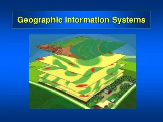
What is GIS? - 1 • Location, location, location SomeHousing Applications • Manage Stock • Allocate housing officer patches • Understand profile of residents • Grounds maintenance
What is GIS? - 2 • How? • Layers of information • Mapping data e.g. Ordinance Survey, Google maps, x and y coordinates • Requires GIS Software
GIS and L&Q - 1 • Cadcorp installation in June 2012 • 3 sessions of on-site training (18 staff) • Mapping Products • – OS Open source • – OS Mastermap imagery • – OS Topography • – Code-point with Polygons • – Address base plus
GIS & L&Q -2 • The journey so far... • Resident profile • Stock profile • Grounds maintenance • Promoting GIS across the Trust
Grounds Maintenance - 1 • Why does L&Q need GM maps using GIS? • Improves the procurement process for Grounds maintenance • Costs saving Resident satisfaction • Clarification of L&Q’s boundaries • Better management of estates • Improves information sharing (internal & external) • Purchase GIS product – Cadcorp • Builds on GIS training
Grounds Maintenance -2 Mapping data • xx and yy coordinates (property points) • Ordinance Survey • Land Registry • How? • Teams • Cross departmental work • External consultants – Oxford Data Consultancy
Grounds Maintenance - 3 • Map Specification • Grounds Maintenance • Site services
Grounds Maintenance - 4 • How many?
24th April 2013 Craig Godwin, Managing Director, Oxford Data Consultancy Grounds Maintenance Data Capture • Housemark – Estates Services Northern Meeting
ODC – Craig Godwin • 25 years experience of GI data capture • Work with all of the leading GIS vendors • Cadcorp • ESRI • Worked with 30+ Housing Associations • Currently working with:
Ground Maintenance Data Capture • Source data • The data capture process • Products / output • Options for Acquiring GIS
Source Data - 1 • Ordnance Survey MasterMap Topography
Source Data – 2 • Paper Ground Maintenance plans
Source Data - 3 • Ordnance Survey Aerial Photography
Source Data - 4 • Transfer Plans
Source Data - 5 • Property points
Source Data - 6 • Land Registry Boundaries
The Process • Acquire / compile source data • Data capture • Identify anomalies • Manual quality assurance • Automated quality assurance • Anomaly clarification • Implement amendments • Export the data
Products - 1 • Bill of quantities
Products - 2 • Paper plans and PDFs
Products - 3 • GIS data
GIS Acquisition Purchase GIS • Acquire GIS • Full functionality and flexibility • Hosted GIS • Data held by external consultants • Information provided via PDF • Limited functionality & access • Cheaper alternative for smaller HAs
Future Plans • Add GM maps to internal housing management system (Arena) • Add the xx and yy coordinates to Arena • Link Cadcorp system to Arena • Overall satisfaction map (neighbourhood, inner/outer London) • ASB Hotspoting(borough, neighbourhood) • Stock data profile (type of stock, neighbourhood) • Create a Top 10 Maps on the intranet