Download
1 / 12
270 likes | 794 Vues
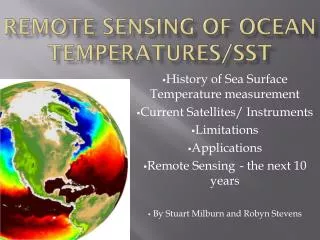
Remote Sensing of Ocean Temperatures/SST. History of Sea Surface Temperature measurement Current Satellites/ Instruments Limitations Applications Remote Sensing - the next 10 years By Stuart Milburn and Robyn Stevens. Remote Sensors love Acronyms.

E N D
Remote Sensing of Ocean Temperatures/SST History of Sea Surface Temperature measurement Current Satellites/ Instruments Limitations Applications Remote Sensing - the next 10 years By Stuart Milburn and Robyn Stevens
Remote Sensors love Acronyms SR ESA HRPT VHRR GEO MCSST AVHRR NOAA ICOADS MODIS NOPP NEMS SMMR NASA SSM/I AMSR GODAE CrIMSS GHRSST-PP TRMM GHRSST- RAN TMI FOAM REMSS MISST POES GOES
Sampling of SST from Ships • Long established record • Reliable data since about 1870 • Less data now than previously http://www2.hawaii.edu/~jmaurer/sst/ ttp://dss.ucar.edu/datasets/ds540.0 /docs/WMO-Pub47_jtech07-1.pdf
Buoys/Drifters/Gliders Drifter Global Tropical Moored Buoy Network http://www2.hawaii.edu/~jmaurer/sst/ http://www-argo.ucsd.edu/ ARGO Floats + Sampling usually taken at a known Depth e.g. SST-1m + Sub-surface sampling - Limited amount of data able to be collected. - Low resolution. Global Drifter Surface Buoy Array ~ 5’ Resolution
Thermal Infrared SST Instruments • SR , VHRR on INSAT3-M • MODIS on TERRA, AQUA • ATSR on ERS-2 • GOES Imager • AATSR on ENVISAT • AVHRR on NOAA series and ESA MetOP-A • Scan at IR wavelengths... • + Good Resolution (~1km) • + Accurate Results • + Long Dataset • - Obscured by Cloud http://sst-remote-sensing.wikispaces.com/ NOAA 12 14 16
Passive Microwave SST Instruments • SMMR on Nimbus-7, SeaSat • TMI on TRMM • AMSR on EOS-PMI • CRIMSS • + Can see through cloud • - Not as accurate or as fine resolution as IR CRiMSS http://en.wikipedia.org/wiki/Moderate-Resolution_Imaging_Spectroradiometer
Limitations to remote Sensing Ocean Temperatures • SST measured at different levels • Skin Layer Diurnally heated • Evaporation • Radiometer Noise • Incidence angle • Radio Interference • Wind forcing alters SST measured http://www2.hawaii.edu/~jmaurer/sst/ Night Day
Data Availability • Archiving websites • Data available graphically • Near real time data • GHRSST: 6 hour delay • NOAA has data from 1981 to present, Oceanwatch • NASA provides data from MODIS since 2000 • WASTAC (West Australian Satellite Technology and Applications Consortium) http://www.wastac.wa.gov.au/
Global Images http://bcc.cma.gov.cn/Website/index.php?ChannelID=2&NewsID=173
Australia and EAC Bureau of Meteorology uses the Advanced Very High Resolution Radiometer (AVHRR) on board the NOAA series of polar orbiting satellites to derive SSTs for the Australian region http://www.cmar.csiro.au/remotesensing /oceancurrents/SNSW/latest.html http://www.bom.gov.au
Applications • Meteorological Forecasting • Climate Models • ENSO Forecasting • Ocean Forecasting • Coral Bleaching • Fishing • Currents • Research and Development http://www.nodc.noaa.gov
What is the Future? • New methods blending thermal IR and passive microwave satellite measurement and improvements with correlating these to in situ SST measurements (with QC) • Improved in situ SST “Ground Truth” • Better SST products through better algorithms/longer dataset/improved instruments • Scientific/International/Australian Collaborations – e.g. BMRC, CSIRO and Universities through ACCESS. Bluelink from BOM • New and improved Acronyms IOCI, SEACI, POAMA MDGSST, GHRSST-RAN, MISST, NPOESS, VIIRS, CrIMSS