Developing an EU Geological Data Platform: Use Cases and Decision-Making Insights
180 likes | 304 Vues
Explore the importance of developing an EGDI for European geological data, user requests, use cases, and stakeholders. Discover how use cases contribute to system design, functionality, and sustainability.

Developing an EU Geological Data Platform: Use Cases and Decision-Making Insights
E N D
Presentation Transcript
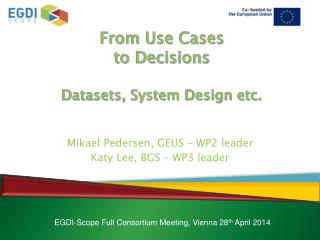
From Use Cases to DecisionsDatasets, System Design etc. Mikael Pedersen, GEUS – WP2 leader Katy Lee, BGS – WP3 leader EGDI-Scope Full Consortium Meeting, Vienna 28th April 2014
General Considerations • Why develop an EGDI? • To make a sustainable platform for European geological datasets and information • Why develop use cases? • To ensure usability of the future EGDI -> Usability is key to sustainability! • What do users request? • Easy accessible and reliable data and information • Intuitive functionality • What do users not have today? • Answers to many basic questions needing geological data.
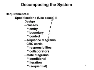
How have use cases contributed • Have provided clearer picture of use situations • Have provided insight into issues dealt with by past European project • Have provided requirements for • Data • Functionality • System design and operation
Stakeholders TowardsUse Cases • Energy minerals / resources • Shale gas, oil shale, shale oil • Solid fuel minerals • Oil and gas • Gas hydrates • Non-Energy minerals / resources • Metals • Industrial minerals • Construction materials Themes Geology • Other natural resources • Freshwater • Soils • Seas and oceans • Other • Geothermal • CCS • Secondary raw materials and waste • Urban • Climate change • Aquifers • Ecosystems • Higher-res geological maps • 3D geology • Marine • Geochemistry • Radioactive waste • Land use Raw Materials Prioritisation Geohazards • Geohazards • Earthquakes • Volcanoes • Flooding • Subsidence • Landslides • Erosion • Mining • Geochemical: Radon, Mercury… Water Partners Soil
From Use Case to Implementation Plan
Datasets for phase 1 Geology • OneGeologyEurope 1: 1 million surface geology • OneGeologyEurope 1:1 million bedrock • EMODnet-Geology I - 1:1 million substrate map Mineral Resources • Promine dataset on mineral deposits,anthropogenicconcentration layers, mineral potential maps, predictive maps • EuroGeoSource dataset on mineral occurrences and mines • -> Minerals4EU & EURare
Datasets for phase 1 Water Resources • Hydrogeological map of Europe (IHME) 1: 1.5 million. • Aquifer Typologies for hydrochemical characterization (BRIDGE project) Geohazards • PanGeo ground stability polygons, geohazard descriptions and associated PSI data Soil • Geochemical distribution maps based on GEMAS • Soil/parent material map?
(Present ) List of Use Cases / 2 Geology • A geologistcreating a geologicalmap of the Alps for an excursion • A geology student making a mapshowing the distribution of Archaean rocks in Europe • A consultant wanting to evaluate and download the marine substratemap from a specific offshore area. Mineral Resources • A geologistpreparing a report of the best REE deposits in Europe for the Commission • An Internet user wanting an overview of the largest REE deposits in Europe
(Present ) List of Use Cases / 2 Water Resources • The EEA assessing the groundwaterchemical status based on naturalbackgroundlevels of pollutants Geohazards • A localauthority planner assessinginhabitedareas in risk of subsidence Superficialdeposits • The EEA wanting to download the 1GE+ geologicalmap of Europe for ecosystemmappingusing desktop GIS applications • The EEA wanting to assess the effect of Phosphorous in superficialdeposits on certain European ecosystems
Example: Mineral Resources Decision Makers The General Public Expert Users
Geological Service –Data Infrastructure or Information System? 3 2 1 Geological Service Knowledge Base Pool of Experts ?
Conclusions • The use cases support the concept of a European Geological Information System • But…. • An underlying data infrastructure will probably be needed in some cases