Download
1 / 13
130 likes | 303 Vues
Seismic Refraction and Double Springs Well Modification on the Walker River Indian Reservation. August 25, 2005 By Kip K. Allander and David L. Berger. Location of Schurz Subarea. Double Springs Well.

E N D
Seismic Refraction and Double Springs Well Modification on the Walker River Indian Reservation August 25, 2005 By Kip K. Allander and David L. Berger
Double Springs Well It is uncertain whether GW is actually leaving the Walker River Basin through the Double Springs area or not. If GW is leaving the Walker River Basin, it is important to understand how much is leaving as well as how much is flowing into Walker Lake. This information is needed to update the Walker Lake water budget. Ground water (GW) enters the Schurz subarea through the Walker Gap and flows parallel to Walker River. Near the community of Schurz, the GW flow may split, with the majority flowing towards Walker Lake, but some may be flowing toward the Double Springs area and eventually discharge into Rawhide Flat. To understand how much GW is leaving the basin, and how much is entering Walker Lake, the cross sectional area that the GW is moving through needs to be known. The USGS is requesting to use a technique called seismic refraction to find the cross sectional area. Seismic refraction is explained in subsequent slides. Additionally, the hydraulic gradient near the Double Springs area would need to be known. In order to measure hydraulic gradient, the water level at the Double Springs Well needs to be measured. A water-level measurement at this well would require a modification that is proposed in subsequent slides. Schaefer, D.H., 1980, Water resources of the Walker River Indian Reservation, West Central NV: USGS OFR 80-427, 60 p.
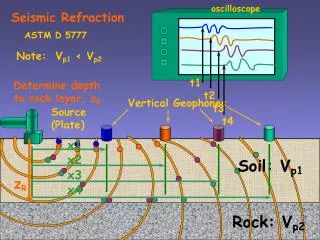
Seismic Refraction • Used to explore subsurface structural geometry • Cost effective – non-invasive method • Would be used to find depth to bedrock
Energy propagation Image obtained on 8/12/2005 from http://www.gns.cri.nz/outreach/qt/quaketrackers/seismo_refract.htm
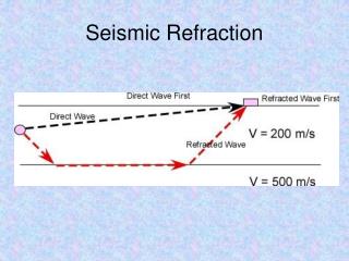
Direct and refracted waves Image obtained on 8/12/2005 from http://www.gns.cri.nz/outreach/qt/quaketrackers/seismo_refract.htm
Direct arrivals from Layer 1 Refracted arrivals from Layer 2 Interpreting first arrivals The different arrival times and the rates at which the first arrivals come in are used to make interpretations of the depth to the different subsurface layers. Image obtained on 8/12/2005 from http://www.gns.cri.nz/outreach/qt/quaketrackers/seismo_refract.htm
Example of raw data Image obtained on 8/12/2005 from http://www.gns.cri.nz/outreach/qt/quaketrackers/seismo_refract.htm
Double Springs Well • Flowing Well with substantial discharge (60 gallons per minute) • Water level is above land surface, but elevation is uncertain? • Water level is needed to determine direction of ground-water flow and hydraulic gradient
Proposed modification • Would allow us to obtain a measurement of the head pressure • Well would still continuously flow into cattle trough
Cut casing above flow from well and remove pipe 7-in Well Flow from hole in casing Proposed modification (cont.)
Pressure gage 10-in PVC pipe Slip 10-in PVC pipe and packer over well. Open faucet. Inflate packer, let flow go out faucet. After packer is fully inflated, close faucet. Read pressure gage. Remove pipe and packer after measurement is made. 7-in Well Packer Water level measurement
After modification and water level measurement, Double Springs well would look like this