Download
1 / 1
20 likes | 168 Vues
The Northern Walker Lane Seismic Refraction Experiment J. N. Louie, S. B. Smith, W. Thelen, J. B. Scott, M. Clark, with T. Makris, T. Rennie, A. Concha, A. Pancha, T. Rasmussen, C. Lopez Seismological Laboratory and Dept. of Geological Sciences, University of Nevada, Reno

E N D
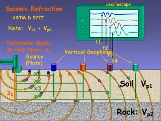
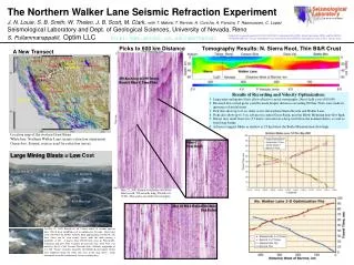
The Northern Walker Lane Seismic Refraction Experiment J. N. Louie, S. B. Smith, W. Thelen, J. B. Scott, M. Clark,with T. Makris, T. Rennie, A. Concha, A. Pancha, T. Rasmussen, C. Lopez Seismological Laboratory and Dept. of Geological Sciences, University of Nevada, Reno S. Pullammanappallil, Optim LLC http://www.seismo.unr.edu/geothermal Funded by cooperative grant DE-FG07-02ID14311 administered by DOE, Idaho Operations Office and the INEEL. 199 IRIS/PASSCAL “Texan” instruments were provided by the PASSCAL Instrument Center at New Mexico Tech. Picks to 600 km Distance Tomography Results: N. Sierra Root, Thin B&R Crust A New Transect Barrick GoldStrike 450-km Array of 199 Texans Barrick Blast C Time Picks Bridgeport Results of Recording and Velocity Optimization: Large mine and quarry blasts allow effective crustal tomography. Direct field costs <$10,000. Reversed first-arrival picks could be made despite distances exceeding 600 km. Picks were made in ignorance of model times. Pick data show up to 6 sec delay across the northern Sierra Nevada and Walker Lane. Picks also show up to 3 sec advance in central Great Basin, near the Battle Mountain heat-flow high. Delays may result from low (5.5 km/s) velocities in a deep root below the northern Sierra, as well as from large basins. Advances suggest Moho as shallow as 25 km below the Battle Mountain heat-flow high. Watsonville Location map of the western Great Basin White line: Northern Walker Lane seismic refraction experiment Green dots: Seismic sources used for refraction survey Blast C Pick Detail Large Mining Blasts = Low Cost C: >80,000 lb A: 20,000 lb B: 40,000 lb May 23, 2002 Barrick GoldStrike 80,000-lb blast record, 100 seconds long, filtered at 8-30 Hz. Time picks are small red rectangles. 40-ft Benches May 22 M2.2 Watsonville Blast Pick Detail On May 23, 2002, Barrick set off 3 blasts about 10 seconds apart at their 1500-ft-deep GoldStrike pit in northeastern Nevada. Each blast used >20,000 lb of ANFO, with the third approaching 100,000 lb. The three blasts can be seen clearly above, with the third causing a landslide, at left. A quarry blast 200-600 km away in Watsonville, California had also been recorded the previous day. That blast was noted by the N. Calif. Seismic Network with a Richter magnitude of 2.2. 200 “Texan” recorders loaned by the PASSCAL Instrument Center were deployed along the white line seen in the map above. Each instrument recorded continuously for two working days.