Download
1 / 25
280 likes | 505 Vues
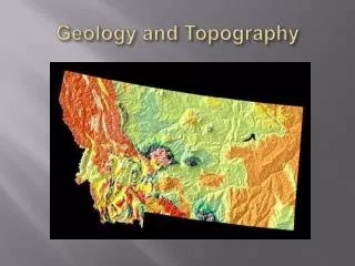
Oklahoma Geography and Geology. Diversity. 70,000 sq miles/45 million acres/18th in size “Panhandle”—added in 1890 Bordered by: Kansas, Colorado, Missouri, Arkansas, Texas, and New Mexico. 10 Distinct Geographic regions KEY WORD—ANOMALY!. 3 MAJOR LANDFORM TYPES:.

E N D
Diversity • 70,000 sq miles/45 million acres/18th in size • “Panhandle”—added in 1890 • Bordered by: Kansas, Colorado, Missouri, Arkansas, Texas, and New Mexico. • 10 Distinct Geographic regions • KEY WORD—ANOMALY!
3 MAJOR LANDFORM TYPES: • Plains—Great Salt Plains, Red Bed Plains, Prairie Plains • Mountains—Ozark, Ouachita, Arbuckle, Wichita • Plateaus/Mesas—Black Mesa, Ozark Plateau
High Plains Gypsum Hills Wichita Mountains Red Bed Plains Arbuckle Mountains Sandstone Hills Prairie Plains Ozark Plateau Ouachita Mountains Red River Plains 10 Geographic Regions
High Plains • Northwestern OK • Level grasslands • High elevation • Low precipitation • Buffalo grass • Juniper and Pinion Trees • Economic Activities: Winter wheat, cattle, petroleum, natural gas
Gypsum Hills • Western OK • Low hills capped with Gypsum • Sandy soil • Extreme temperatures • Shallow Rivers • Low precipitation • Similar to Red Bed plains
Wichita Mountains • SW Oklahoma • Made of Granite and Rhyolite. • Among the oldest mountains on Earth.
Red Bed Plains • Western/ Central Oklahoma • Largest region in Oklahoma • Rolling prairie • Forest in eastern part • 32 inches of rain/ year • Tall bluegrass and short buffalo grass • Post oak and Black jack oak trees • Wide rivers • Red soil • Economic Activities: Winter wheat cotton, cattle, horses, natural gas, and oil
Arbuckle Mountains • Southern Oklahoma • Low mountains • Unusual rock formations • Cattle grazing
Sandstone Hills • North-central Oklahoma • Rolling Hills • Tall prairie grass • Scrub oak trees • Sandy soil • Blackjack and Post oak trees • Oil Drilling began here
Prairie Plains • Northeastern OK • Low Sandstone Ridges • High forested ridges • Rivers run N to S • Bluestem grass • Economic Activities: Coal, oil, natural gas, livestock, agriculture
Ozark Plateau/ Ouachita Mtns. • Northeast OK • Huge forests filled with Hickory, Oak and Pine Trees • Unique rock formations, springs, and waterfalls, • Deep rivers • Economic Activities: Wood pulp processed, coal, cattle grazing.
Red River Plains • Southeastern Oklahoma • Low elevation • Sandy soil • Long growing seasons • Pine and Cypress Trees • Agriculture/ Fertile Soil, Livestock, • Evidence of old plantations worked by slave labor
TWO MAJOR RIVER SYSTEMS: • Arkansas—Cimarron, Verdigris, Canadian, Illinois • Red—North Fork, Washita, Kiamichi • All flow West to East…
West to East • Less rain more rain • Higher elevation lower elevation • Black Mesa-elevation: 4973 ft. -rainfall: 15 in/yr McCurtain County: elevation: 300 ft. -rainfall: 52 in/yr
Red Dirt • Very FERTILE!! • 1997 Agricultural production $4,146,351,000 • Crops=22% • Livestock=78%
Climate • Warm Gulf air + cool northern air= TORNADOES—mainly in spring • Average wind speed= 14 mph; perfect for WIND power
McClellan-Kerr Navigation System • McClellan-Kerr Navigation System—series of locks and dams on Arkansas River to decrease flooding, increase trade/commerce. • Originates at Tulsa’s Port of Catoosa and runs southeast through OK and Arkansas to Mississippi River.
400 Million Years Ago • Vast prehistoric sea covered this area and plant and animal debris sank to the sea floor eventually becoming coal deposits.
300 Million Years Ago • Volcanic eruptions/ plate shifts caused mountains to rise up (Arbuckles) and waters became trapped beneath the surface (ground water). • These became aquifers that still supply water for large areas of Oklahoma • Oglalla Aquifer could cover the entire surface of the state to a depth of 7 feet. • Value: $1 Billion
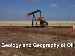
65 Million Years ago • Dinosaurs became extinct, but their remains formed what would become SWAMP TREASURE: PETROLEUM (crude oil and natural gas). • Vast oil and gas fields lay beneath OK today as a result. • 1983: value reached a high of $11 Billion • 1997: $6 billion • OK is among the 5 leading oil producing states • OK is third highest natural gas producer.
Mineral Industry • Greatest source of state revenue • Total oil production: over 14 billion barrels since 1891 (all time high was 1927—278 million barrels) • Top five oil-producing areas: • near Ardmore and Healdton in Carter County, near Enid in Garfield County, and near Guymon in Texas County. • Total natural gas production: over 85 trillion cubic feet since 1905. • The largest Natural Gas fields: • Texas County and Beaver County and Haskell County
Extra Credit • What is the scientific name for rose rocks? • Why is our dirt red? • When was the most powerful earthquake in Oklahoma? • When was the most recent?