Download
1 / 35
350 likes | 437 Vues
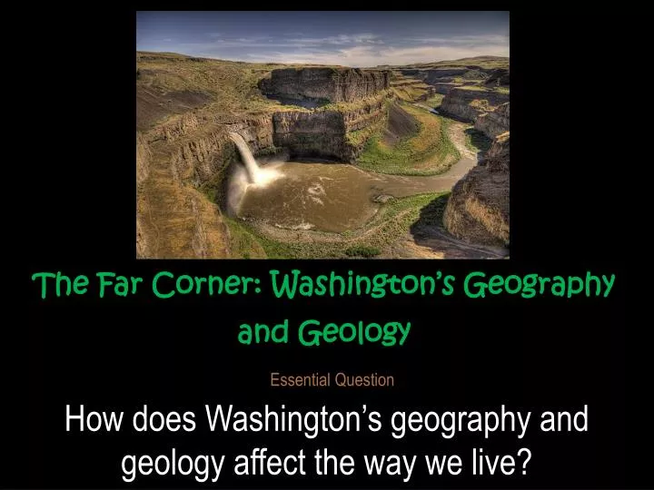
The Far Corner: Washington’s Geography and Geology. Essential Question. How does Washington’s geography and geology affect the way we live?. First Let’s review Directions on a map. Using your thumb in front of your body. Point Which way is North. North. Point Which way is South. South.

E N D
The Far Corner: Washington’s Geography and Geology Essential Question How does Washington’s geography and geology affect the way we live?
Using your thumb in front of your body Point Which way isNorth North
Point Which way isSouth South
W E S N Your fingers moving North…
W E S S Your fingers at the bottom…
W E S E Your fingers moving east…
W E W E S
The Northwest Corner Washington’s location?? • In the Northwest corner of the United States • Between the 46th and 49th parallels north latitude • Between 117 degrees and 125 degrees west longitude
The Columbia River makes most of the natural southern boundary • A political boundary separates Washington from Idaho on the eastern side • The Pacific Ocean and the Strait of Juan de Fuca make natural western boundaries Canada Washington’s Boundaries: • Canada makes the north political boundary Northern Border Eastern Border Washington’s Coast - Western Border Washington Southern Border
Spatial Patterns • Coastlines, rivers, deserts, and mountains affect where people live and work. • Humans have had an impact on the land over the years. • Loggers cut down too many trees • Hunters shot too many wild animals • Fishermen caught too many salmon • People changed the land to meet their needs • Today, people and companies act more responsibly to take care of the land.
The Columbia River • The Columbia River is one of Washington’s most famous physical characteristics. • Indian tribes and early fur trappers used the river for transportation and a source of food. • The river became the source of a thriving salmon industry.
The source of the river is at Columbia Lake, high in British Columbia, Canada. • The Columbia has many tributaries and flows into the Pacific Ocean. • The Columbia is the most powerful river in North America in terms of hydroelectric energy. mouth of the Columbia Columbia Lake Grand Coulee Dam
The Pacific Coast • Washington has 157 miles of ocean coastline. • The Strait of Juan de Fuca has over 3,000 miles of coastline. • Washington has deep-water harbors that link it to the rest of the world.
Puget Sound Area • The Pacific Ocean and the Puget Sound are the sources of the state’s fishing industry. • Salmon, oysters, crabs, shrimp, halibut, flounder, tuna, and cod are caught in Washington’s waters. • Winds from the ocean give Washington a mild climate.
What Regionis Washington Part of? • Regions are… • places that share common features. • Washington is part of the Pacific Northwest region. • A region of states that share common physical, political, and economic features • Washington is part of the Pacific Rim region. • A region of all the countries that border the Pacific Ocean
Washington’s Five Regions • Each region has at least one main physical feature but may contain more. • The Coastal Range • Narrow region along the Pacific Ocean with rainforests, mountains, and other forests
The Puget Sound Lowlands • Plains and valleys around the Puget Sound with fertile land and access to rivers and seaports
The Cascade Range • Includes the Cascade Mountain range with its high volcanic peaks and many glaciers
The Columbia Plateau • A high, flat plateau on the east side of the Cascades with dry land and natural vegetation
The Rocky Mountain Region • Steep hills that are foothills of the Rocky Mountains in the northern corner of the state
A Jigsaw Puzzle • Scientists believe Washington is made of many small continents. • Millions of years ago, they came together because of the earth’s shifting plates. • Tectonic forces uplifted, tilted, and folded the earth’s crust to create mountains.
Tectonic forces left fault lines that shift and cause earthquakes every few years. • Mountains were also formed by volcanic action.
The Cascade and Olympic Mountains are part of a great Ring of Fire.
Volcanoes Shaped theColumbia Plateau • Lava covered the Columbia Plateau. • Volcanic ash and dust covered parts of the Plateau and created rich soil. • Today, this is the Palouse wheat-growing region in eastern Washington.
The Lessons of Mt. St. Helens • Mt. St. Helens erupted on May 18, 1980. • The eruption was equal to 21,000 atomic bombs. • The destruction was great and 57 people lost their lives. • Some people ignored warning signs and stayed near the mountain. • The mountain will erupt again. http://www.youtube.com/watch?v=njV9ski1gB4
Ice Age Washington • About 1 million to 10,000 years ago, an ice age covered much of Washington with snow and ice. • Glaciers grew and shrank as the temperature changed. • Moving glaciers shaped the Puget Sound Lowlands. • Ice dams blocked rivers and formed prehistoric lakes. • Water broke through dams, causing immense floods. • Every 50 years or so for 2,000 years, floods occurred. • Grand Coulee was created during the ice age by ice and floodwater. Giant Current Ripples were created by deep, fast moving water.[Columbia River boat for scale] The Ice Age Floods etched many deep canyons and coulees into the Columbia River Basalt that blankets much of eastern Washington. Scabland Channel cut by Glacial Lake Missoula floodwater. Stev H. Ominski’s interpretation of what Dry Falls WA would have looked like (not so dry). Glacier Perito Moreno breaks down Sunday, March 14, 2003 for the first time in 16 years in Lago Argentino, some 3,200 kilometers, (2,000 miles) southwest of Buenos Aires, Argentina Perito Moreno Glacier in the providence of Santa Cruz, Argentina
Fossils are Clues to the Past • Fossils of plant and animal life tell us about the region in which they were found. • Shells and bones from ancient sea life tell us that oceans once covered our land. • Plant fossils in central Washington indicate that a large tropical rainforest once flourished there.
Coal was formed by the combination of prehistoric plants, heat, and pressure over millions of years. • Deposits of coal and other fossils that can be burned are considered fossil fuels. • Environmentalists warn that greenhouse gases are produced by burning fossil fuels.