Download
1 / 41
410 likes | 919 Vues
The Global Positioning System and Other Global Navigation Satellite Systems. July 19, 2006. Jason Y. Kim, Senior Advisor National Space-Based Positioning, Navigation, and Timing (PNT) Coordination Office Washington, D.C., USA. Overview. Introduction GPS Performance Next-Generation GPS

E N D
The Global Positioning System and Other Global Navigation Satellite Systems July 19, 2006 Jason Y. Kim, Senior Advisor National Space-Based Positioning, Navigation, and Timing (PNT) Coordination Office Washington, D.C., USA
Overview • Introduction • GPS Performance • Next-Generation GPS • Cooperation with Galileo • Cooperation with GLONASS • Other Systems
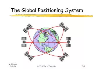
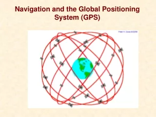
The Global Positioning System • Baseline 24 satellite constellation in medium earth orbit • Global coverage, 24 hours a day, all weather conditions • Satellites broadcast precise time and orbit information on L-band radio frequencies • Two types of signals: • Standard (free of direct user fees) • Precise (U.S. and Allied military) • Three segments: • Space • Ground control • User equipment
Nationwide Differential GPS Wide Area Augmentation System Continuously Operating Reference Stations Local Area Augmentation System U.S. Augmentations
Differential GPS Networks Space-Based Augmentation Systems Global Differential GPS System International GNSS Service International Augmentations
GPS is a Global Public Service • Free access to civilian signals • One-way broadcast, like FM radio • Public domain documentation • Anyone can develop user equipment • Worldwide utility providing consistent, predictable, dependable performance • Critical component of global information infrastructure • Owned and operated by the U.S. Government • Paid for by U.S. taxpayers • Guided at a national level as multi-use asset • Acquired and operated by Air Force on behalf of USG Available Now—Empowering the Future
Organizational Structure WHITE HOUSE Defense Transportation NATIONALSPACE-BASED PNT EXECUTIVE COMMITTEE Co-Chairs: Defense, Transportation State ADVISORYBOARD Sponsor: NASA Commerce Homeland Security NASA COORDINATIONOFFICE Host: Commerce Joint Chiefs of Staff
Europe: Galileo, EGNOS Russia: GLONASS Japan: MSAS, QZSS India: GAGAN, IRNS Australia: GRAS China: Beidou, Compass Canada: CWAAS Mexico: WAAS Multilateral: International GNSS Service Most major nations: Differential GPS, geodetic reference networks Galileo partners: China, India, Canada, Mexico, Ukraine, Israel, Morocco, South Korea; discussions ongoing with Brazil, others International Growth in Global Navigation Satellite Systems (GNSS)
Provide civil GPS and augmentations free of direct user fees on a continuous, worldwide basis Provide open, free access to information needed to develop equipment Improve performance of civil GPS and augmentations to meet or exceed that of international systems Encourage international development of PNT systems based on GPS Seek to ensure international systems are interoperable with civil GPS and augmentations Or at a minimum, are compatible Address mutual security concerns with international providers to prevent hostile use U.S. Cooperation Strategy Outlined in Presidential policy on space-based positioning, navigation, and timing (PNT)
Overview • Introduction • GPS Performance • Next-Generation GPS • Cooperation with Galileo • Cooperation with GLONASS • Other Systems
Constellation Status • 16 Block II/IIA satellites • 12 Block IIR satellites • Modernizing 8 remaining Block IIR satellites • 1 Block IIR-M satellite • Transmitting new L2C signal • Continuously assessing constellation health to determine launch need • Next launch: September 2006 • All future satellites will feature L2C 29 Operational Satellites (Baseline Constellation: 24)
Civil GPS Performance Standards U.S. commitments to civil GPS performance are documented in the GPS Standard Positioning Service Performance Standard (2001) “In support of the service availability standard, 24 operational satellites must be available on orbit with 0.95 probability (averaged over any day). At least 21 satellites in the 24 nominal plane/slot positions must be set healthy and transmitting a navigation signal with 0.98 probability (yearly averaged).”
GPS Signal in Space Performance Performance Standard Decreasing range error Signal in Space RMS URE: Root Mean Square User Range Error System accuracy far exceeds current standard
Alaska England USNO Wash, DC Cape Canaveral Bahrain South Korea Hawaii Kwajalein Diego Garcia Ecuador Ascension Australia Tahiti South Africa Argentina New Zealand Ground Antennas NGA Monitoring Stations Future NGA Monitoring Stations Air Force Monitoring Stations Ground Segment Expansion for Improved GPS Accuracy • Tripling the amount of GPS monitor data to improve accuracy and integrity of existing system • 10-15% improvement in accuracy of GPS data broadcast Schriever AFB VandenbergAFB Master Control Station (MCS) Alternate MCS
. Improving GPS Performance with Augmentations Augmentations enhance GPS accuracy, monitor integrity • Sub-centimeter accuracy for geodesy, geology, etc. • 2-5 cm accuracy for real-time positioning, surveying, etc. • <3 m vertical accuracy with 6 second time to alarm for aviation
GPS Performance with WAAS U.S. Federal Aviation Administration developed the Wide Area Augmentation System (WAAS) to provide the necessary accuracy, integrity, and availability to support flight operations during all phases of flight Based on observations from January to March 2006. Results are valid when the Localizer Approach with Vertical Guidance (LPV) service is available. During this time frame, LPV was available 98% to 99% of the time.
GPS Performance with CORS Post-Mission Positioning Accuracy Based on dual-frequency GPS carrier-phase observations
Overview • Introduction • GPS Performance • Next-Generation GPS • Cooperation with Galileo • Cooperation with GLONASS • Other Systems
Benefits of Next-Generation GPS • For civil users: • Higher standalone accuracy • Robustness against interference • Improved indoor, mobile, and urban use • Interoperability with other GNSS constellations • For military: Enhances navigation warfare • For all users: • System-wide improvements in accuracy, availability, integrity, and reliability • Backward compatibility • Maintains international competitiveness
GPS Modernization Program Increasing System Capabilities w Increasing Defense / Civil Benefit Block IIA/IIR Block IIR-M, IIF Block III • Basic GPS • Standard Service • Single frequency (L1) • Coarse acquisition (C/A) code navigation • Precise Service • Y-Code (L1Y & L2Y) • Y-Code navigation • IIR-M: IIA/IIR capabilities plus • 2nd civil signal (L2C) • M-Code (L1M & L2M) • IIF: IIR-M capability plus • 3rd civil signal (L5) • Anti-jam flex power • Backward compatibility • 4th civil signal (L1C) • Increased accuracy • Increased anti-jam power • Assured availability • Navigation surety • Controlled integrity • Increased security • System survivability
Second Civil Signal (“L2C”) • Freely available since December 2005 • Currently on 1 satellite • Will be on all future satellites • Designed to meet commercial needs • Higher accuracy through ionospheric correction • Benefits thousands of existing high-end receivers using L2 frequency • Higher effective power and improved data structure reduce interference, speed up signal acquisition, enable miniaturization of receivers, may enable indoor use • Expected to create over $5 billion in user productivity benefits • Full benefits will arrive after more satellites are launched and ground control system is upgraded 1227 MHz (L2) Begins with GPS Block IIR-M First launch: 2005 24 satellites: ~2014 Signal defined in IS-GPS-200
Third Civil Signal (“L5”) • Designed to meet demanding requirements for transportation safety • Higher power than other GPS civil signals • Wider bandwidth improves resistance to interference • Uses highly protected Aeronautical Radio Navigation Service (ARNS) band • New signal structure for enhanced performance • May also enable global, centimeter-level accuracy via multi-signal techniques • Interoperable with Galileo’s E5a signal 1176 MHz (L5) Begins with GPS Block IIF First launch: ~2007* 24 satellites: ~2016 Signal defined in IS-GPS-705 * Currently Reassessing Date
Fourth Civil Signal (“L1C”) • Designed with international partners to enable GNSS interoperability • Galileo Open Service • Japan’s Quasi-Zenith Satellite System • Possibility for GLONASS? • Modernized civil signal at L1 frequency • Aeronautical Radio Navigation Service Band • Improved code and carrier tracking • New message structure • L1 C/A will be retained for backwards compatibility 1575 MHz (L1) Begins with GPS Block III First launch: ~2013 Signal defined in IS-GPS-800 (draft)
GPS III • Next-generation satellite bus needed to accommodate increasing power requirements • Revised acquisition strategy: • Spiral development approach to reduce risk, increase flexibility • Separate contracts for space and ground segments to ensure “best of breed” technology • Civil benefits: • Provides operational capability for L2C and L5 • In combination with GPS IIR-M and IIF satellites • Delivers L1C for interoperability with Galileo, QZSS • Significant increase in system accuracy • Improved availability of accuracy with integrity
GPS III Proposed Accuracy • Draft System Specifications: • Includes the effects of receivers • Threshold = low-cost/low-performance receiver • Objective = high-cost/high-performance receiver
Overview • Introduction • GPS Performance • Next-Generation GPS • Cooperation with Galileo • Cooperation with GLONASS • Other Systems
U.S. GPS Cooperation • U.S. Government has pursued formal cooperative arrangements with Europe, Japan, Russia since 1996 • To ensure compatibility (non-interference) and interoperability with foreign systems • To protect national security • To maintain level playing field in the global market • Additional efforts under way with Australia, India, Brazil • Multilateral cooperation established through U.N. International Committee on GNSS • As well as ICAO, IMO, NATO
GPS-Galileo Agreement • In 2004, United States and European Community signed historic agreement on GPS-Galileo cooperation, recognizing importance of compatibility and interoperability for all parties • Agreed to spectrally separate signals for military, civilian, and public regulated services • Agreed to implement a common, open, civil signal on both Galileo and GPS III, free of direct user fees • Working groups establishedto continue dialogue: • Compatibility & Interoperability • Trade & Commercial Applications • Next-Generation GNSS • Security Issues June 26, 2004, press conference at U.S.-EU Summit in Ireland (U.S. Sec. of State Colin Powell, Irish Foreign Minister Brian Cowen, EU Vice-President Loyola De Palacio)
Working Group A:Compatibility & Interoperability • Common civil signal for GPS and Galileo (L1C/L1F) • Centered on L1 frequency used by GPS today • Agreement includes baseline modulation scheme but allows for “optimization” • Working Group A spent 21 months collaborating towards optimized signal design • Optimized design (“MBOC”) achieved in March 2006 • Satisfies all compatibility requirements • Still awaiting formal acceptance at political level • Time and geodesy • GPS and Galileo are based on different time standards and geodetic reference frames • Broadcasting GPS-Galileo Time Offset will solve time problem • Geodesy offset considered insignificant (<5 cm)
Characteristic Common time and reference frames, or broadcast offsets Common carrier frequencies Similar spreadingmodulation spectra Common spreading code lengths and common code family Common data message structure and encoding Interoperability Benefit Navigation solutions can blend measurements from different systems Common antenna and receiver front end—lower power and cost; common carrier tracking for higher accuracy Common-mode dispersive errors removed in navigation solution for higher accuracy Lower cross-correlation sidelobes for better weak-signal reception; common receiver processing for acquisition and tracking Common receiver processing for data message decoding and processing Most Important for FutureInteroperability Improving GNSS Interoperability
Working Group B:Trade & Commercial Applications • Agreement includes provisions to maintain level playing field in GNSS market • Recognizes obligations under World Trade Organization • Affirms nondiscriminatory approach to trade in GNSS goods/services • Requires equal access to open signals and technical information needed for receiver development • Requires consultations on proposed measures affecting GNSS use • U.S. remains guarded about Galileo business plan • Not fully revealed due to concessionaire process • Licensing, royalties on chipsets not well understood • Fee structure for subscription services unknown • Interface Control Document for Galileo signals released in 2006 • Positive step towards providing access to technical information • However, questions remain • U.S. intends to convene Working Group B in fall time frame
Working Group C: Development of Next Generation Civil GNSS Harmonization of GPS L2C, L5, and L1C with Galileo E5 safety-of-life and commercial services Joint monitoring of GPS/Galileo civil signals Joint coordination on system maintenance, satellite tracking, and back-up capabilities for civil applications Next-generation augmentation techniques Coordination of multilateral efforts to protect civil GNSS spectrum through non-ITU bodies (ICAO, IMO, etc.) Working Group D: Security Issues Preventing technology transfer to third parties Protection of Galileo Public Regulated Service Other Working Groups
Overview • Introduction • GPS Performance • Next-Generation GPS • Cooperation with Galileo • Cooperation with GLONASS • Other Systems
Russia • United States and Russian Federation issued Joint Statement establishing cooperation in 2004 • Continue to provide GPS and GLONASS civil signals on a continuous, worldwide basis, free of direct user fees • Cooperate on matters of mutual interest related to GNSS in relevant international organizations and fora • Maintain radio frequency compatibility between systems • Promote civil interoperability between systems • Annual consultations and workinggroups established • Currently pursuing formal cooperation agreement GLONASS satellite
Working Group 1: GPS-GLONASS Compatibility and Interoperability October 2005, Moscow June 2006, Cocoa Beach Pursuing increased GPS-GLONASS radio frequency compatibility and user equipment interoperability Working Group 2:COSPAS/SARSAT (Search and Rescue Capability) June 2005, London March 2006, Moscow September 2006, Las Vegas Significant progress being made toward technical coordination of search and rescue capabilities on future satellites Working Group Meetings
Overview • Introduction • GPS Performance • Next-Generation GPS • Cooperation with Galileo • Cooperation with GLONASS • Other Systems
Japan • World’s largest consumer of GPS technology • U.S.-Japan cooperation began in 1998 • Initially focused on interoperability with MSAS, Japan’s GEO-based augmentation system • Promotes common principles such as free market access • Annual plenary meetings, technical working groups • Current focus is on Quasi-Zenith Satellite System (QZSS) • Regional system to complement, augment GPS over Japan • Will improve performance in urban canyons and mountains • Will freely broadcast GPS L1C, L2C, L5 signals • GPS-QZSS interoperability achieved MT-SAT used for MSAS
Characteristic Common time and reference frames, or broadcast offsets Common carrier frequencies Similar spreadingmodulation spectra Common spreading code lengths and common code family Common data message structure and encoding Interoperability Benefit Navigation solutions can blend measurements from different systems Common antenna and receiver front end—lower power and cost; common carrier tracking for higher accuracy Common-mode dispersive errors removed in navigation solution for higher accuracy Lower cross-correlation sidelobes for better weak-signal reception; common receiver processing for acquisition and tracking Common receiver processing for data message decoding and processing GLONASS-GPSGLONASS-GALILEO GLONASS-QZSS ? ? GPS-GALILEOQZSS-GALILEO ? GPS-QZSS Current View of GNSS Interoperability
Multilateral group chartered through United Nations First meeting: December 2005 Purpose: Promote use of GNSS to improve efficiency and security of transport, search & rescue, geodesy, etc., particularly in developing countries Coordination among providers to improve compatibility and interoperability Assistance to developing countries in integration of PNT services Focal point for international information exchange Forum for addressing future user needs International Committee on GNSS
Summary • U.S. policy encourages worldwide use of civil GPS and augmentations • GPS performance is better than ever and will continue to improve • Augmentations enable high performance today • New GPS signal now available • Many additional upgrades scheduled • International cooperation is a priority • Compatibility and interoperability are critical
“Muito Obrigado!” National Space-Based PNT Coordination Office6822 Herbert C. Hoover Building Washington, D.C. 20230USA pnt.office@pnt.gov+1 (202) 482-5809 PNT.GOV