
Lower Coquille Watershed Analysis: Overview and Hydrologic Characteristics
E N D
Presentation Transcript
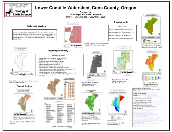
Watershed Parameter Total Drainage Area (sq. meter)= 269,258,378m² Total Drainage Area (sq. km)= 269.25km² Total length of Watershed (sq km)= 28.23km Total width of Watershed (sq km)= 22.79km Watershed Length/Width ratio= 1.23 Total No. of Sub-basins in Watershed= 12 Average Area of Sub-basins in Watershed= 22.43km² Total No. Stream Segments or Tributaries in Watershed= 1613 Total No. First Order Stream Segments= 815 Total No. Second Order Stream Segments= 381 First Order Stream Frequency (Total No. / Drainage Area sq. km)= 3.20 perkm² Lower Coquille Watershed, Coos County, Oregon Prepared by: Chris Meyer and Alicia Thompson ES 341: Fundamentals of GIS, Winter 2009 Physiographic Watershed Location Spatial Analyst Minimum Watershed Elevation (feet)= 0 Maximum Watershed Elevation (feet)= 512 Minimum Slope (decimal degrees)= 0 Maximum Slope (decimal degrees)= 66.5 The Lower Coquille Watershed, part of the Coquille Basin is located in Southwest Oregon in Coos county (see figure 1). The Coquille River is the major river system which includes four stems: South Fork, Middle Fork, North Fork and East Fork. They join to become the Main Stem or Lower Coquille River. Figure 1. Map of Oregon with watershed location (UTM Coordinate System) Figure 9. Digital Elevation Model with slopemap (UTM Coordinate System) Hydrologic Summary Figure 6. Digital Raster Grid Quadrangles map (UTM Coordinate System) Figure 2. Watershed outlines and stream overlays (UTM Coordinate System) Figure 5. Digital Orthophoto Quadrangles map (UTM Coordinate System) Figure 7. Digital Elevation Model Quadrangles map (UTM Coordinate System) General Geology Reference: Lower Coquille Watershed Maps: Geographic Information Systems: Oregon 1:24,000 Quadrangle Names http://libweb.uoregon.edu/map/map_section/quad_list.htm Database: USGS: SAGEMAP http://sagemap.wr.usgs.gov/SearchData.aspx Database:Oregon Geospatial Enterprise Office (GEO)http://www.oregon.gov/DAS/EISPD/GEO/alphalist.shtml#O Lower Coquille Watershed Information site: Coquille Watershed (HUC 17100305) http://www.or.nrcs.usda.gov/programs/csp/watershed-coquille.html Lower Coquille Watershed Information site: Coquille Watershed Association http://www.coquillewatershed.org/ Lower Coquille Watershed Information site: Welcome to Inforain: Coquille Subbasin Working Atlas http://www.inforain.org/coquille_atlas/index.html Theme: Class Web Site http://www.wou.edu/las/physci/taylor/es341/es341_w09.htm http://terra.geo.orst.edu/ucgis/datasoft.html http://www.blm.gov/nstc/gis/GISsites.html http://www.fws.gov/data/statdata/ordata.html http://data.geocomm.com/catalog/US/61056/index.html http://or.water.usgs.gov/pubs_dir/Online/Cd/WRIR99-4036/GIS_FILES/index.html http://data.geocomm.com/catalog/US/61056/430/index.html http://tin.er.usgs.gov/geology/state/state.php?state=OR http://www.google.com/Top/Science/Social_Sciences/Geography/Geographic_Information_Systems/Data/ http://gos2.geodata.gov/ http://www.oregon.gov/DAS/EISPD/GEO/alphalist.shtml http://nationalmap.gov/ http://soildatamart.nrcs.usda.gov/ Figure 3. Geologic Map (UTM Coordinate System) Figure 8. Climate map (UTM Coordinate System) Figure 8. Vegetation map (UTM Coordinate System) Figure 4. Soil Map (UTM Coordinate System)