Download

1 / 32
320 likes | 334 Vues
This study explores the potential impacts of climate change on flow and water quality in the Upper Mississippi River Basin using a hydrological model. The research includes calibration and validation of the model, as well as analyzing various climate inputs and their effects on stream flow. The study also discusses the potential changes in water quality due to climate change. More research is needed to fully understand the impact on water quality.

E N D
Potential Climate Change Impacts on Flow and Water Quality in the Upper Mississippi River Basin Eugene S. Takle Iowa State University Ames, IA 50011 USA gstakle@iastate.edu Project collaborators: Manoj Jha, Zaitao Pan, Roy Gu Iowa-Minnesota Drainage Research Forum 27 November 2007
Outline • Domain and hydrological model (SWAT) • Calibration and validation • Observations -> stream flow • NNR -> RCM -> SWAT-> stream flow • GCM -> RCM -> SWAT-> stream flow • GHG -> GCM -> RCM -> SWAT -> stream flow • Stream flow vs. precipitation For details see: Jha, M., Z. Pan, E. S. Takle, and R. Gu, 2003: Impacts of climate change on stream flow in the Upper Mississippi River Basin: A regional climate model perspective. Journal of Geophysical Research.
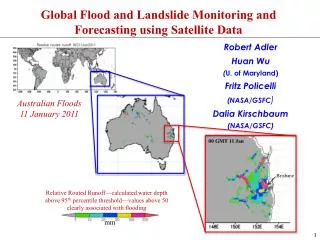
Sub-Basins of the Upper Mississippi River Basin 119 sub-basins Outflow measured at Grafton, IL Approximately one observing station per sub-basin Approximately one model grid point per sub-basin
Soil Water Assessment Tool (SWAT) • Long-term, continuous watershed simulation model (Arnold et al,1998) • Daily time steps • Assesses impacts of climate and management on yields of water, sediment, and agricultural chemicals • Physically based, including hydrology, soil temperature, plant growth, nutrients, pesticides and land management
SWAT Output with Various Sources of Climate Input
Calibration of SWAT: Annual Stream Flow at Grafton, IL
Calibration of SWAT: Monthly Stream Flow at Grafton, IL
Validation of SWAT: Annual Stream Flow at Grafton, IL
Validation of SWAT: Monthly Stream Flow at Grafton, IL
RegCM2 Simulation Domain Red = global model grid point Green/blue = regional model grid points
Annual Stream Flow Simulated by SWAT Driven by the RegCM2 Regional Climate Model with NNR Lateral Boundary Conditions
Mean Monthly Precipitation Simulated by the RegCM2 Regional Climate Model with NNR Lateral Boundary Conditions
Seasonal Stream Flow Simulated by SWAT Driven by the RegCM2 Regional Climate Model with NNR Lateral Boundary Conditions
Hydrological component comparison • between RegCM2 and SWAT Note: All values are in mm per year averaged for 1980-1988 in NNR run.
SWAT Output with Various Sources of Climate Input
Ten-Year Mean Monthly Stream Flow Generated by the RegCM2 Regional Climate Model Driven with HadCM2 Global Model Results for the Contemporary and Future Scenario (2040s) Climate
Ten-Year Mean Precipitation Generated by the RegCM2 Regional Climate Model Driven with HadCM2 Global Model Results for the Contemporary and Future Scenario (2040s) Climate
Errors in Simulated Stream Flow and Climate Change
Comparison of Simulated Stream Flow under Climate Change with Various Model Biases
Hydrologic Budget Components Simulated by SWAT under Different Climates All units are mm Yield is sum of surface runoff, lateral flow, and groundwater flow
Relation of Runoff to Precipitation for Various Climates
Regression Analysis: Stream Flow vs. Precipitation
Water Quality(Results from GCM Study) • Fugitive nitrates and sediment from the landscape are both carried by overland flow related to runoff • The dominant pathway for nitrate loss is through leaching to groundwater and then via baseflow or tile drains (Randall, 2001). • Results show a substantial decrease in runoff in the future climate but increase in baseflow, although with less agreement among models.
Water Quality(Results from GCM Study) • Both sediment and nitrate loading of streams would decrease due to decreased runoff but nitrate leaching might increase. • Although water quality might improve due to reduced sediment, the loading due to nitrates is less clear but might increase.
Summary • RCM provides meteorological detail needed by SWAT to resolve sub-basin variability of importance to streamflow • There is strong suggestion that climate change introduces changes of magnitudes larger than variation introduced by the modeling process • Relationship of streamflow to precipitation might change in future scenario climates • More research is needed to assess impact on water quality