Download
1 / 13
140 likes | 288 Vues
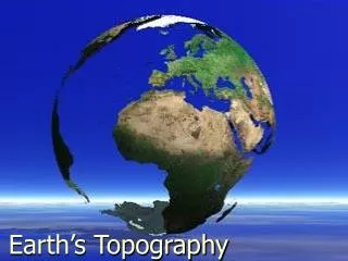
This overview explores the Earth's coordinate system, which uses latitude and longitude to determine locations on the planet's surface. The Equator (0° latitude) serves as a reference for latitude, indicating how far north or south a point is. The Prime Meridian (0° longitude), running from pole to pole through Greenwich, England, serves as the reference for longitude, showing how far east or west a point is. We also discuss map projections, including the distortions that occur in polar regions, and explain how distances are calculated using latitude and longitude.

E N D
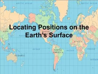
Coordinate System • Surface grid used to locate any position on the Earth • Latitude and Longitude
System uses two reference points: • Equator – (00 latitude) • Imaginary line that circles the earth • The angular distance north or south of the equator is called latitude • Lines of latitude are parallel to each other 2. Prime Meridian (00 longitude) • Runs from the north pole to the south pole through Greenwich, England • The angular distance east or west of the Prime Meridian is called longitude. • Longitude lines meet at the poles and run north to south
Lines of latitude and longitude on the Globe P R I M E M E R I D I A N Equator--
Notice the distortion in the polar regions. South America is actually 9 times the size of Greenland
An area of the world will always be distorted with these projections. Projections
Projections Map Projections.asf
Distance using Latitude • One degree of latitude = 111km • Each degree is divided into 60 minutes (60’) Each minute = 1.85km • Each minute is divided into 60 seconds (60”) • 420 30’ 15” N is read as 42 degrees, 30 minutes and 15 seconds north • This means the location is 4718km north of the equator
Distance using Longitude • At the equator, one degree of longitude = 111km • As you go towards the poles, this distance decreases