Plate techtonics and ocean bathymetry
310 likes | 479 Vues
Plate techtonics and ocean bathymetry. Historical context. Alfred Wegener first suggested in 1915 that continents can move over time. *Based on visual match of coastlines between continents. Harry Hess then hypothesized in 1960 that mantle convection drives the spread of sea floor.

Plate techtonics and ocean bathymetry
E N D
Presentation Transcript
Plate techtonics and ocean bathymetry
Historical context • Alfred Wegener first suggested in 1915 that continents can move over time. *Based on visual match of coastlines between continents • Harry Hess then hypothesized in 1960 that mantle convection drives the spread of sea floor. *Based on seafloor topographic features such as midocean ridges and trenches
Creating new ocean crust Theory of Plate Tectonics begins to be accepted in the 1960s
F.Vine and D. Matthews demonstrated that spreading seafloor shows imprint of magnetic reversals (1963).
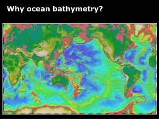
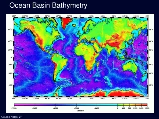
More evidence: age of ocean crust http://www.ngdc.noaa.gov/mgg/geology/geology.html
Oceanic crust moves away from Mid Oceanic Ridge (MOR) and cools and subsides Age of Oceanic Crust (Red = young)
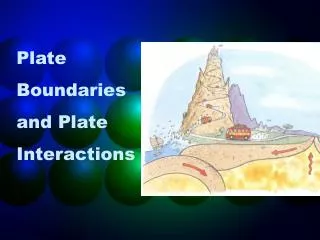
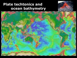
3-3 Constructive margins Midocean ridges Destructive margins Subduction zones Driving Mechanisms for Plate Motions
How fast is the sea floor spreading? • Satellite GPS measurement • It depends on locations • 2-10 cm/year • Size of ocean basin and the age of crust • The age of old Pacific crust is 100+ million years • The width of ocean basin is about 10,000km
Type of boundary between plates: Constructive margins Midocean ridges Destructive margins Subduction zones Conservative margins Transform faults
Mapping the upper mantle (astenospere) with seismic wave tomography
Conservative margins Transform faults
Conservative margins Transform faults The San Andreas fault in southern California
Life cycle of Plates “The Wilson Cycle”
Atolls Palmyra Island Fanning Island
Other ways Plate Tectonics affect ocean circulation and climate?
1978 • Mt. St. Helens • Cascade’s most historically active volcano • Erupted May 18,1980 (~0.1- 0.3 km3) • Killed 57 people • Threatens nearby Portland • Had considerable, but mostly unobserved deformation prior to eruption 2002
Mt. Pinatubo, Philippines • Erupted June 15, 1991 • World’s largest eruption in 75 years (~10km3) • 58,000 evacuated • 320 lives lost (mostly sickness & roof collapse)
Effects of Volcanic eruptions on the solar incoming radiation Agung1963 Pinatubo1991 Chichón 1982
Cartoon of Volcanic Impacts on the Earth Heat Budget Robock, Reviews of Geophysics, 38, 2 / May 2000
Late JurassicThe supercontinent of Pangea began to break apart in the Middle Jurassic. In the Late Jurassic the Central Atlantic Ocean was a narrow ocean separating Africa from eastern North America. Eastern Gondwana had begun to separate form Western Gondwana Cretaceous During the Cretaceous the South Atlantic Ocean opened. India separated from Madagascar and raced northward on a collision course with Eurasia. Notice that North America was connected to Europe, and that Australia was still joined to Antarctica.
K/T extinctionThe bull's eye marks the location of the Chicxulub impact site. The impact of a 10 mile wide comet caused global climate changes that killed the dinosaurs and many other forms of life. By the Late Cretaceous the oceans had widened, and India approached the southern margin of Asia. Eocene 50 - 55 million years ago India began to collide with Asia forming the Tibetan plateau and Himalayas. Australia, which was attached to Antarctica, began to move rapidly northward.
3-2 Sea-Floor Spreading • Whereas oceanic ridges indicate tension, continental mountains indicate compressional forces are squeezing the land together. Sedimentary Rocks Squeezed by Compression
Miocene20 million years ago, Antarctica was coverd by ice and the northern continents were cooling rapidly. The world has taken on a "modern" look, but notice that Florida and parts of Asia were flooded by the sea. Last Ice Age When the Earth is in its "Ice House" climate mode, there is ice at the poles. The polar ice sheet expands and contacts because of variations in the Earth's orbit (Milankovitch cycles). The last expansion of the polar ice sheets took place about 18,000 years ago.
Modern World We are entering a new phase of continental collision that will ultimately result in the formation of a new Pangea supercontinent in the future. Global climate is warming because we are leaving an Ice Age and because we are adding greenhouse gases to the atmosphere.