Download

1 / 16
280 likes | 856 Vues
Use of Remote Sensing Imagery and Techniques in Land Use/Land Cover Change Analysis. NRE 441 Sadahisa Kato April 13, 2004. Introduction. Definition of land use Definition of land cover Land use/land cover pattern reflects physical and cultural geography.

E N D
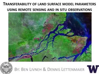
Use of Remote Sensing Imagery and Techniques in Land Use/Land Cover Change Analysis NRE 441 Sadahisa Kato April 13, 2004
Introduction • Definition of land use • Definition of land cover • Land use/land cover pattern reflects physical and cultural geography. • Human-induced changes are altering the landscape. • Land use change affects our lives! • Land use/land cover maps can tell us a lot.
Scientific Background • Humans are changing the landscape at an unprecedented rate. • Land-use change is often accompanied by alterations in land cover. • Human-induced landscape change can have undesirable impacts.
Scientific Background • Remote sensing can greatly contribute to the studies of land use/land cover change. • Satellite remote sensing can be used to map land use/land cover and monitor the changes in land cover. • Land use/land cover maps tell us the amount and location of change as well as the future change.
Remote Sensing Applications • Aerial photography is useful where greater detail of land surface is needed. • Satellite remote sensing is useful where global coverage is required. • Both static and dynamic attributes of land cover can be used to infer the drivers of change. • Other socio-economic and environmental data can be combined with remote sensing data for analysis.
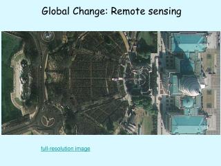
Remote Sensing Applications Pseudo true-color satellite image of Madison County, Alabama in 1990 (Source: Laymon 2003)
Remote Sensing Applications Land cover/land use classification of Madison County, Alabama in May 2000 (Source: Laymon 2003)
Remote Sensing Applications Maps showing the distribution of Developed and Undeveloped land in Madison County in 1984, 1990, and 2000 (Source: Laymon 2003)
Remote Sensing Applications Map showing the distribution of Developed and Undeveloped land in Madison County that experienced no change in land use from 1984 to 1990 or from 1990 to 2000, and land that changed from Undeveloped to Developed.
Remote Sensing Applications Maps showing the percent change in Developed land area for cities and townships in Madison County between 1984 to 1990 and 1990 to 2000 (Source: Laymon 2003)
Remote Sensing Applications • Remote sensing sensors used in land use/cover mapping: NOAA’s AVHRR, Landsat MSS, Landsat TM and ETM+, SPOT, and so on. • Satellite image data can be used in two major ways: a spatial frame of reference and a basis for information derivation through data processing and analytic procedures. • Land use/land cover maps tell us how much the landscape has changed, where the changes are taking place, and where the future changes are likely to occur.
Remote Sensing Applications • Data from satellite imagery can be entered into GIS with other types of planning data to compute changes within political and ecological boundaries. • Land use/cover maps are used for predicting the future development trend, establishing conservation objectives, and testing different development scenarios.
Remote Sensing Applications Graph of Developed land area in Madison County, Alabama estimated from satellite imagery (observations) with extrapolation to 2020 (Source: Laymon 2003)
Remote Sensing Applications Map showing the distribution of Developed and Undeveloped land in Madison County in 2020 projected from observations of the same in 1984, 1990, and 2000 (Source: Laymon 2003)
Conclusion • Land use/land cover pattern reflects physical and cultural geography. • Humans are altering the landscape at an unprecedented rate and some of the changes have undesirable effects. • Remote sensing can be used to map land use/land cover and monitor the changes in land cover. • Land use/land cover maps tell us the amount and location of change as well as the future change. • Other socio-economic and environmental data can be combined with remote sensing data for analysis and make future predictions.
Sources • Laymon, C. (2003) Satellite remote sensing of land use change. <http://www.directionsmag.com/article.php?article_id=365>. • Center for International Earth Science Information Network (2004) Uses of satellite image data for assisting human dimensions studies of global environmental change. <http://www.ciesin.org/TG/RS/uses.html>. • LUCC International Project Office (2004) Land use and land cover change. <http://www.geo.ucl.ac.be/LUCC/lucc.html>. • Center for Remote Sensing and Spatial Analysis (2004) New Jersey landscape change research. <http://www.crssa.rutgers.edu/projects/lc/index.html>.