Warm-Up
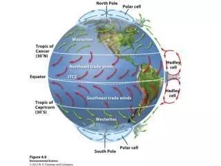
Warm-Up. What is the Coriolis Effect? How does it affect air currents on Earth? What causes the seasons? (Why is it hot in the summer and cold in the winter?). Earth's Tilt and the Seasons. The Earth's axis of rotation is tilted 23.5 ⁰

Warm-Up
E N D
Presentation Transcript
Warm-Up What is the Coriolis Effect? How does it affect air currents on Earth? What causes the seasons? (Why is it hot in the summer and cold in the winter?)
Earth's Tilt and the Seasons The Earth's axis of rotation is tilted 23.5⁰ When the Northern Hemisphere is tilted toward the sun, the Southern Hemisphere is tilted away from the sun, and vice versa http://www.youtube.com/watch?v=taHTA7S_JGk&feature=player_embedded
Ocean Currents Ocean currents are driven by a combination of temperature, gravity, prevailing winds, the Coriolis Effect, and the locations of continents Warm water, like warm air, expands and rises
Ocean Currents http://www.youtube.com/watch?v=sgOgXL4GVwA
Ocean Currents – Heat Transport Ocean currents can affect the temperature of nearby landmasses For example, England's average winter temperature is approximately 20˚C (36˚F) warmer than Newfoundland, Canada, which is located at a similar latitude
Ocean Currents Gyres – large-scale patterns of water circulation The ocean surface currents rotate in a clockwise direction in the Northern Hemisphere and a counterclockwise direction in the Southern Hemisphere
Upwelling Upwelling – as the surface currents separate from one another, deeper waters rise and replace the water that has moved away This upward movement of water brings nutrients from the ocean bottom that supports the large populations of producers, which in turn support large populations of fish
Warm-Up What causes upwellings to occur? What effects does this have on marine life? Which is more dense: freshwater or saltwater? What happens when they meet? What is El Nino?
Thermohaline Circulation Thermohaline circulation– oceanic circulation that drives the mixing of surface water and deep water Scientists believe this process is crucial for moving heat and nutrients around the globe Thermohaline circulation appears to be driven by surface waters that contain unusually large amounts of salt
Thermohaline Circulation Some of the water that flows from the Gulf of Mexico to the North Atlantic freezes or evaporates, and the salt that remains behind increases the salt concentration of the water This cold, salty water is relatively dense, so it sinks to the bottom of the ocean, mixing with deeper ocean waters These two processes create the movement necessary to drive a deep, cold current that slowly moves past Antarctica and northward to the northern Pacific Ocean
Thermohaline Circulation http://www.youtube.com/watch?v=w_8mw-1HYFg&feature=related http://www.youtube.com/watch?v=3niR_-Kv4SM&feature=related
Warm-Up What causes thermohaline circulation? What effects does it have on the Earth? What happens during El Nino?
El Nino-Southern Oscillation Every 3 to 7 years, the interaction of the Earth's atmosphere and ocean cause surface currents in the tropical Pacific Ocean to reverse direction
El Nino-Southern Oscillation First, the trade winds near South America weaken This weakening allows warm equatorial water from the western Pacific to move eastward toward the west coast of South America The movement of warm water and air toward South America suppresses upwelling off the coast of Peru and decreases productivity there, reducing fish populations near the coast These periodic changes in wind and ocean currents are collectively called the El Nino-Southern Oscillation (ENSO)
Rain Shadows Air moving inland from the ocean contains a large amount of water vapor meets the windward side of a mountain range (the side facing the wind), it rises and begins to experience adiabatic cooling Because water vapor condenses as air cools, clouds form and precipitation falls The presence of the mountain range causes large amounts of precipitation to fall on its windward side
Rain Shadows The cold, dry air then travels to the other side of the mountain range (the leeward side), where it descends and experiences higher pressures, which causes adiabatic heating This air is now warm and dry, and creates arid conditions on the leeward side (a rain shadow) http://bcs.whfreeman.com/thelifewire/content/chp56/5602001.html