
Uploaded by
callum-levy
1 SLIDES
142 VUES
10LIKES
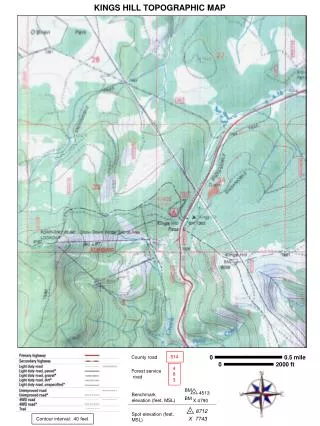
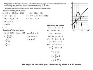
Kings Hill Topographic Map with Benchmark Elevations and Forest Service Road Details
DESCRIPTION
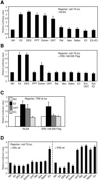
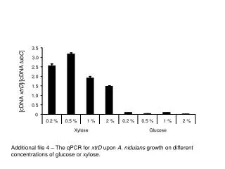
This detailed topographic map of Kings Hill features essential geographical information including Forest Service Road 514 and Benchmark elevations. The map highlights significant points such as BM 4513 at 8712 feet and spot elevation X7743. With a contour interval of 40 feet, this map is ideal for hikers, campers, and outdoor enthusiasts seeking to navigate this mountainous terrain effectively. It provides valuable insights into elevation changes and road access, making it a crucial resource for exploring the Kings Hill area.
Download
1 / 1
Télécharger la présentation 
Kings Hill Topographic Map with Benchmark Elevations and Forest Service Road Details
An Image/Link below is provided (as is) to download presentation
Download Policy: Content on the Website is provided to you AS IS for your information and personal use and may not be sold / licensed / shared on other websites without getting consent from its author.
Content is provided to you AS IS for your information and personal use only.
Download presentation by click this link.
While downloading, if for some reason you are not able to download a presentation, the publisher may have deleted the file from their server.
During download, if you can't get a presentation, the file might be deleted by the publisher.
E N D
Presentation Transcript
514 County road 4 8 3 Forest service road BM 4513 0 0.5 mile BM X 4790 0 2000 ft Benchmark elevation (feet, MSL) 8712 Spot elevation (feet, MSL) X7743 KINGS HILL TOPOGRAPHIC MAP Contour interval: 40 feet


More Related
Audio
Live Player