Download
1 / 12
120 likes | 352 Vues
Water conflict:. World water hotspots. Ogallala aquifer ( wikipedia ). Can you find answers to these? An aquifer is a body of rock that can contain or transmit ground water. The Ogallala aquifer was about 2,925,000,000 acre feet (3,608km 3 ) in 2005.

E N D
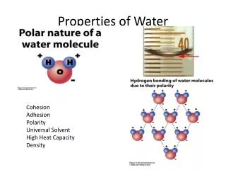
Water conflict: World water hotspots
Ogallala aquifer (wikipedia) Can you find answers to these? • An aquifer is a body of rock that can contain or transmit ground water. • The Ogallala aquifer was about 2,925,000,000 acre feet (3,608km3) in 2005. • The aquifer has been reduced by 9% (312km3) since groundwater irrigation development began in the 1950s. • This decrease is caused by the groundwater irrigation development that began in the 1950s. • Not it was not, as there was a risk that the material could contaminate and poison the Ogallala aquifer. • However, an oil pipeline was allowed to be built because the U.S. State Department found that the route would be economically practical and would be unlikely to have significant effects on the environment surrounding it. • Water conservation practices (terracing and crop rotation), more efficient irrigation methods can be put into practice in order to help conserve the water in this particular area. • The Ogallala aquifer is presently known as the High Planes aquifer.
Mexico City http://www.time.com/time/world/article/0,8599,1890623,00.html A serious water shortage has been taking place in Mexico City: a dry and highly populated city in the Western hemisphere where water is a commodity that is heavily relied on by its citizens. However, the stoppage in the city’s main reservoir in order to ration the depleting supplies has left five million people suffering. This sudden cutback on water has prevented the lower class citizens to struggle as they find themselves with little to drink and even less for other basic necessities such as showering. What with Mexico sinking into an old lake bed at a rate of three inches per year, extra pressure is put on water distribution pipes which consequently leak about 40% of liquid before it reaches homes. Mexico City now relies on the Cutzamala system, which is a network of reservoirs and treatment plants that gathers water from approximately 1000 miles around. But to make matters worse, Cutzamala is now running dry, with the main basin only 47% full instead of the normal 70%. Although there is no specific cause for the decrease of water in the main basin, it is suggested that the cause could be climate change or deforestation. With Mexico City’s rapidly increasing population, its government is forced to plan ahead and figure out how to support their citizens.
Lake Chad http://news.bbc.co.uk/2/hi/africa/6261447.stm http://www.unicef.org/infobycountry/chad_57642.html Why are the fishermen around Lake Chad packing up their nets? Due to climate change and excessive irrigation schemes have contributed to Lake Chad shrinking by 95%, with a prediction that the lake could shrink down to a mere pond in merely two decades. Once being Africa’s third largest inland body of water, several people and generations have found themselves dependent on this source of fresh water, and with Chad’s population rising access to water has become an even more coveted commodity. On average about 20 to 30 million people are dependent on Lake Chad, and are being greatly affected by this rapid decrease in their water source. Fishing; once a popular trade, is now an inconvenient way of feeding families. Fishermen who relied on Lake Chad for their food now find it too much of a hassle to go out for hours just to catch a single fish too small to feed a a family and have resorted to farming instead, using the rich soil that was once at the bottom of the lake bed to grow crops. Lake Chad’s receding water level also heightens risk of malnutrition and disease, which already contributes to 1/3 of deaths among children under five.
The River Nile • Find a map showing the countries the River Nile flows through. • Mark on the source of the Nile: Lake Victoria. • Mark on its mouth. • Label the Nile delta. A delta is a landform that is at the mouth of a river where the river flows into a body of water. • The River Nile flows from South to North. • Ethiopia, Uganda, Kenya, Tanzania and Rwanda all want to extract water from the Nile. • The total annual rainfall for Egypt is 80mm or less. The average July temperature is approximately 35 to 40 degrees Celsius. • Because of the high temperatures, Egyptians rely heavily on water to keep them hydrated as well as to keep their plants and cattle alive. The River Nile being a large source of freshwater it is no wonder that several countries are fighting for a share of it. Rains and reservoirs are other freshwater sources that Egypt has.
http://www.water-technology.net/projects/south_north/ http://www.renewbl.com/2010/10/26/three-gorges-dam-reaches-maximum-capacity-for-the-first-time-ever.html China Three Gorges Dam The north of China has suffered from very limited water resources for years. This urgent problem has led to the over-exploitation of groundwater which has in turn led to severe water shortages and droughts. Land subsidence and the region’s frequent sandstorms have also been linked to the excessive use of groundwater. To solve the problem of water scarcity in the north, China has been building a Western route of water diversion that once completed in 2050, will bring 4 billion cubic metres of water from three tributaries of the Yangtze to northwest China. However, in the South of China there is a consistent abundance of water, which at times has lead to devastating floods which has affected thousands of people. The Three Gorges dam’s main purposes were to provide power generation capabilities, control and prevent shipping and and floods Yangtze River The 3 main uses of water in the north are to satisfy the demand for it by its increasing population,
River Ganges On the next slide: Create a collage photos to show: • The source of the Ganges • The mouth of the Ganges • A simple map showing where it flows • Three pictures showing three main sources of pollution • Label each photo so you know what it is • A sentence saying what the G. A. P. is and what type of pollution it is aimed at • A sentence saying how this type of pollution is being reduced
Source of River Mouth of Ganges Where it flows G.A.P. stands for ‘Ganga Action Plan’, which is aimed at improving the water quality and treatment of domestic sewage and preventing toxic, industrial and chemical waste from contaminating the river. (Water Pollution.) This problem with water pollution is being solved by intercepting the sewage and diverting it for treatment. 3 Main Sources of Pollution
Spain: water shortage Desalinationis a process that… A desalination plant look like this: t Three reasons Spain needs desalination plants are: • Their climate is very hot, so its people are more dependent on water than in colder countries. • Rivers are being polluted and therefore cannot be used as drinking water. • Water shortages due to climate change across the country. Two other countries that needs desalination plants are: Australia and Saudi Arabia.
Southern Australia Reservoir Large Height Difference Dam Wall Turbines and Generators HEP generated here Outflow pipes
Iraq • Hyperlink that tells you about the Marsh Arabs and how their lifestyle has been under threat: http://news.bbc.co.uk/earth/hi/earth_news/newsid_9364000/9364044.stm
Challenge:if time - Israel http://www.ifamericansknew.org/cur_sit/water.html Use this and other websites to see if you can work out what is happening in this area of the world. How much water do people in these two countries get each? Who gets the water from the River Jordan? Why is there conflict over water in Israel and Palestine? Be aware that the website given may be biased.