Download
1 / 9
90 likes | 99 Vues
The final product of drone mapping or aerial surveying in construction is a map. The two most prevalent ways of mapping with drones are photogrammetry and laser ranging (LiDAR). Using either way, you'll get a different kind of map and you'll need specialised tools to analyse the data.<br><br>Visit: https://justpaste.it/maps-drone-mapping

E N D
Common Types of Maps Obtained From Drone Mapping https://www.falcon3dme.com
Drone mapping or aerial surveying in construction produces maps as the final delivery. Photogrammetry and LiDAR are the two most common drone mapping methods. Both methods produce distinct mapping results and necessitate the use of specific data processing software to analyse the data. The common types of maps obtained from drone mapping are: • Orthomosaic maps • Digital Elevation Models (DEM) • Digital Surface Models (DSM) and Digital Terrain Model (DTM) • Contour line maps • 3D point clouds • 3D Textured Mesh
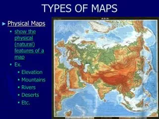
1. Orthomosaic Maps A top-down map of a survey site is called an orthomosaic map or ortho-map. The camera creates a composite image by looking straight down at a survey site or object. Drones capture digital photos that are stitched together to form a 2D orthomosaic map. When the area to be surveyed is large, this map is created. A drone equipped with high-resolution cameras aids in the creation of comprehensive, centimeter-accurate ortho-maps. An ortho-map provides a realistic representation of the project's progress, allowing for quick decision-making and analysis.
2. Digital Elevation Models (DEMs) DEMs are visual representations of elevation data for every point the drones captured on the location. DEMs employ colours to depict elevation differences rather than a physical representation of the site. For each x and y coordinate, DEMs generate grids that list the highest vertical point along the z-coordinate. A smaller grid cell indicates that the DEM data file has more precise information. It includes terrain models with a lot of detail.
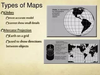
3. Digital Surface Model (DSM) and Digital Terrain Model (DTM) DEM is a subset of DSM and DTM. DTM is a bare-earth surface model that includes only the terrain and ground, whereas DSM includes all obtained points and represents both man-made and natural features on the earth's surface. DTM and DSM models are shown in the diagram below. DTM tracks the ground, whereas DSM displays it. DSM depicts the surface structures, such as the tops of buildings and trees.
4. Contour Line Maps Topographic maps, often known as contour maps, are two-dimensional maps made up of lines connecting equal elevation locations. These are known as contour lines. Peaks and valleys are depicted on contour maps, along with the slope's steepness. A contour line map is created using a DTM or DSM model with specific contour intervals. This gives a better understanding of the region shot by the drone's surface.
5. 3D Point Clouds The drone photos are converted into a 3D point cloud, which is then densified. It consists of hundreds of points, each of which is a geometric coordinate. Each point has both geographical (x,y,z) and colour data. To create a 3D model, all of these coordinates are integrated. The model becomes denser as the number of coordinates rises. 3D point clouds produce an accurate model with easily determined distance, area, and volume.
6. 3D Texture Mesh The evolution of 3D point clouds is a 3D texture mesh. It replicates the region shot by the drone's edges, faces, vertices, and texture. It is suitable for visual examination and is great for project progress monitoring. Track, map, survey, inspect, and manage your worksite projects with Falcon.3D Source : https://justpaste.it/maps-drone-mapping
Do you have any questions? falcon3dmeuae@gmail.com 97143271414 https://www.falcon3dme.com THANKS!