Comprehensive Guide to Topographic Mapping Techniques
Learn about topographic mapping, data collection methods, stadia radiation, relief depiction, contour lines, and survey techniques like property and route surveys for construction sites or hydrographic surveys.

Comprehensive Guide to Topographic Mapping Techniques
E N D
Presentation Transcript
Topographic Mapping • Almost All Surveys Produce Maps • Property Survey • Route Survey • Construction Site Plan • Hydrographic Survey • Topographic Survey • Locates and identifies features • Shows “Relief” – ups and downs of the surface
Data Collection • Collect data on features: • Identify X, Y, Z coordinates of points • Baseline Offsets • Stadia Radiation • Collect data on relief • Aerial Photogrammetry • Cross-sectioning
Sta 0+97 76’ right Sta 0+72 80’ right Baseline Offsets • Set Baseline • Set end points • Assign stationing • Offsets • Perpendicular to baseline • R or L • Calculate • Coordinates • Elevations Assign Pt. A Sta 0+00
123’ at 37°00’ 108’ at 48°00’ Stadia Radiation • Set Baseline • Record • Azimuth • Distance • Calculate • Coordinates • Elevations
Stadia • Indirect Distance Measurement • Can be used to determine • Distance from transit • Elevation difference • Coordinates • Uses Optics of Telescope • Focal Length, f • Spacing of extra cross-hairs, i
Stadia Internal Focus: (c + f) = 0 External Focus: (c + f) = 1 ft
Stadia Interval f/i = 100 4.27-3.98 = 0.29 0.29*100 = 29 feet Note accuracy: 1 ft
Inclined Stadia for small angles, s’ s cos
Inclined Stadia Example Given: a = 20°15’ HI = 4.50’ s = 1.62’ Rod reads 4.81’ ElevA = 100.0’
Stadia Collection Fig 14-13, Page 270
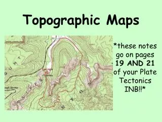
Relief • Requires vertical control – Benchmarks • May be shown by: • Color • Hachures • Contour Lines • Lines of equal elevation • Contour interval • Index contours • Small spacing = steep slope
Contour map rules • V = valley • C = hilltop • Smooth, not straight • Can’t simply end • Uniform slopes • Grade to contour
Fig 14-4 Page 260
Fitting Contours Fig 14-5, pg 261